
Air traffic control (ATC) is a service provided by ground-based air traffic controllers (people) who direct aircraft on the ground and through a given section of controlled airspace, and can provide advisory services to aircraft in non-controlled airspace. The primary purpose of ATC worldwide is to prevent collisions, organise and expedite the flow of traffic in the air, and provide information and other support for pilots.

Luis Muñoz Marín International Airport is a joint civil-military international airport located in suburban Carolina, Puerto Rico, three miles (5 km) southeast of San Juan. It is named for Luis Muñoz Marín, Puerto Rico's first democratically elected governor, and was known as Isla Verde International Airport until it was renamed in February 1985. It is the busiest airport in the Caribbean region by passenger traffic. Over 4 million passengers board a plane at the airport per year according to the Federal Aviation Administration, making it the 48th busiest airport overseen by said federal agency.

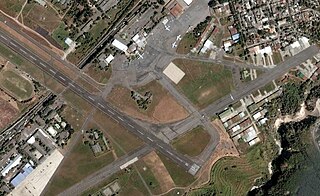
Rafael Hernández International Airport is a joint civil-military airport located in Aguadilla, Puerto Rico. It is named after the Puerto Rican composer Rafael Hernández Marín. It is Puerto Rico's second largest international airport in terms of passenger movement. It is located in Porta del Sol tourist region, in Puerto Rico's west coast. It is also home to Coast Guard Air Station Borinquen and to the Caribbean Branch of the U.S. Customs and Border Protection Air and Marine Operations. The airport has the longest runway in the Caribbean region.

Newark Liberty International Airport is an international airport straddling the boundary between the cities of Newark in Essex County and Elizabeth in Union County, in the U.S. state of New Jersey. Located about 4.5 miles (7.2 km) south of downtown Newark and 9 miles (14 km) west-southwest of Manhattan in New York City, it is a major gateway to points in Europe, South America, Asia, and Oceania. It is jointly owned by the cities and leased to its operator, the Port Authority of New York and New Jersey. It is the second-busiest airport in the New York airport system behind John F. Kennedy International Airport but far ahead of LaGuardia Airport.

Charleston International Airport is a joint civil-military airport located in North Charleston, South Carolina, United States. The airport is operated by the Charleston County Aviation Authority under a joint-use agreement with Joint Base Charleston. It is South Carolina's busiest airport; in 2023 the airport served over 6.1 million passengers in its busiest year on record. The airport is located in North Charleston and is approximately 12 miles (19 km) northwest of downtown Charleston. The airport serves as a focus city for Breeze Airways. It is also home to the Boeing facility that assembles the 787 Dreamliner.

Brunei International Airport (BIA), , is the primary international airport and official airport of entry; one of two airports in the Sultanate of Brunei Darussalam, on the island of Borneo.

Francisco Bangoy International Airport, also commonly known as Davao International Airport, is the main airport serving Davao City and Davao Region in the Philippines. Serving as the main gateway to Mindanao, it is the busiest airport on the island and the third busiest in the Philippines in 2022.

Eppley Airfield, also known as Omaha Airport, is an airport in the midwestern United States, located three miles (5 km) northeast of downtown Omaha, Nebraska. On the west bank of the Missouri River in Douglas County, it is the largest airport in Nebraska, with more arrivals and departures than all other airports in the state combined. It is classified as a medium hub airport by the Federal Aviation Administration (FAA). It is owned and operated by the Omaha Airport Authority (OAA).

Atlantic Airlines de Honduras was an airline based in La Ceiba, Honduras, which operated domestic and regional passenger flights, mostly out of the city's Golosón International Airport, as well as Toncontín International Airport (Tegucigalpa).

Toronto Pearson International Airport is an international airport located in Mississauga, Ontario, Canada. It is the main airport serving Toronto, its metropolitan area, and the surrounding region known as the Golden Horseshoe. The airport is named in honour of Lester B. Pearson, who served as the 14th Prime Minister of Canada (1963–1968) and received the Nobel Peace Prize in 1957 for his humanitarian work in peacekeeping.

The Airports Authority of India (AAI) is a statutory body under the ownership of the Ministry of Civil Aviation, Government of India. It is responsible for creating, upgrading, maintaining, and managing civil aviation infrastructure in India. It provides Communication Navigation Surveillance/Air Traffic Management (CNS/ATM) services over the Indian airspace and adjoining oceanic areas. AAI currently manages a total of 137 airports, including 34 international airports, 10 Customs Airports, 81 domestic airports, and 23 Civil enclaves at Defence airfields. AAI also has ground installations at all airports and 25 other locations to ensure the safety of aircraft operations. AAI covers all major air routes over the Indian landmass via 29 Radar installations at 11 locations along with 700 VOR/DVOR installations co-located with Distance Measuring Equipment (DME). 52 runways are provided with Instrument landing system (ILS) installations with Night Landing Facilities at most of these airports and an Automatic Message Switching System at 15 Airports.

Prayagraj Airport, also known as Allahabad Airport, is the domestic airport serving the city of Prayagraj, Uttar Pradesh, India. Located in the Bamrauli suburb of the city, it is one of the oldest airports in India. This airport is currently under joint operation of the Indian Air Force and the Airports Authority of India. It is the third busiest airport in Uttar Pradesh after Lucknow International Airport and Varanasi International Airport in terms of passenger traffic and aircraft movements.

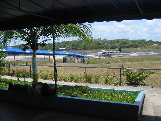
Benjamín Rivera Noriega Airport is a public use airport on the island of Culebra in Puerto Rico. The airport is owned by the Puerto Rico Ports Authority. It is included in the National Plan of Integrated Airport Systems for 2011–2015, which categorized it as a general aviation airport. However, the airport does offer scheduled passenger service.
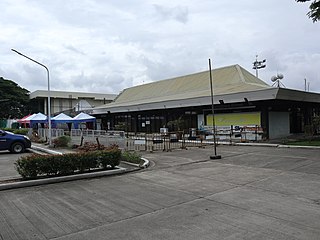
Tuguegarao Airport is an airport serving the general area of Tuguegarao, the capital city of the province of Cagayan in the Philippines. Located along Maharlika Highway, the airport is accessible from adjacent municipalities in Cagayan and northern Isabela. It is classified as a major commercial domestic airport by the Air Transportation Office.
Ilopango International Airport is an airport located on the eastern part of the city of San Salvador, El Salvador, once serving the city as its international airport until 1980 when it was replaced by the larger and more modern El Salvador International Airport, located about 50 km south of the city. Currently, Ilopango is used for military, air taxi, and charter aviation only. It also holds the annual Ilopango Air Show. The airport is also home to the National Aviation Museum of San Salvador, which is housed in the old terminal building.

South Bend International Airport is a commercial and freight airport located three miles northwest of downtown South Bend, in St. Joseph County, Indiana, United States. It is the state's second busiest airport in terms of passenger traffic after Indianapolis International Airport.
Bluefields International Airport is an airport serving Bluefields, a harbor city in the South Caribbean Coast Autonomous Region of Nicaragua. It is the busiest airport in the Caribbean coast of Nicaragua.

El Salvador International Airport Saint Óscar Arnulfo Romero y Galdámez, , previously known as Comalapa International Airport and as Comalapa Air Base to the military, is a joint-use civilian and military airport that serves San Salvador, El Salvador. It is located in the south central area of the country, in the city of San Luis Talpa, Department of La Paz, and occupies a triangular plain of 2,519.8 acres (1,019.7 ha), which borders the Pacific Ocean to the south, is bordered to the east by the Jiboa River, and to the northwest by the coastal highway. Being close to sea level, it allows aircraft to operate efficiently at maximum capacity. It is connected to the capital of San Salvador, El Salvador, through a modern four-lane motorway, with 42 kilometres (26 mi) travel in an average time of 30 minutes.

Joseph A. Hardy Connellsville Airport is a public-use airport located four nautical miles southwest of Connellsville in Dunbar Township, Fayette County, Pennsylvania, United States. It is owned by the Fayette County Airport Authority and serves the south-eastern segment of the Pittsburgh metropolitan area. The airport serves the general aviation community with no scheduled commercial airline service.
