Pukwana, South Dakota

Last updated

Pukwana, South Dakota
Town
Brule County South Dakota Incorporated and Unincorporated areas Pukwana Highlighted.svg
Location in Brule County and the state of South Dakota
Coordinates: 43°46′45″N99°11′03″W / 43.77917°N 99.18417°W / 43.77917; -99.18417
CountryUnited States
State South Dakota
County Brule
Founded1881 [1]
Area
[2]
  Total0.77 sq mi (1.99 km2)
  Land0.77 sq mi (1.99 km2)
  Water0.00 sq mi (0.00 km2)
Elevation
[3]
1,565 ft (477 m)
Population
 (2020) [4]
  Total233
  Density303.78/sq mi (117.34/km2)
Time zone UTC-6 (Central (CST))
  Summer (DST) UTC-5 (CDT)
ZIP code
57370
Area code 605
FIPS code 46-52220 [5]
GNIS feature ID1267539 [3]

Pukwana is a town in Brule County, South Dakota, United States. The population was 233 at the 2020 census. [6]

Contents

Pukwana was laid out in 1881. [7]

In 1955, the local residents made a push to get the new Brule County Courthouse relocated to town, however the city of Chamberlain managed to keep it after battling petitions were made. [8]

Geography

According to the United States Census Bureau, the town has a total area of 0.76 square miles (1.97 km2), all land. [9]

Demographics

Historical population
CensusPop.Note
1910 164
1920 19217.1%
1930 30759.9%
1940 258−16.0%
1950 30217.1%
1960 247−18.2%
1970 208−15.8%
1980 23412.5%
1990 26312.4%
2000 2879.1%
2010 285−0.7%
2020 233−18.2%
U.S. Decennial Census [10] [4]

2010 census

As of the census [11] of 2010, there were 285 people, 115 households, and 70 families residing in the town. The population density was 375.0 inhabitants per square mile (144.8/km2). There were 133 housing units at an average density of 175.0 per square mile (67.6/km2). The racial makeup of the town was 79.6% White, 10.9% Native American, 0.7% Asian, 0.4% from other races, and 8.4% from two or more races. Hispanic or Latino of any race were 4.2% of the population.

There were 115 households, of which 29.6% had children under the age of 18 living with them, 47.8% were married couples living together, 7.8% had a female householder with no husband present, 5.2% had a male householder with no wife present, and 39.1% were non-families. 29.6% of all households were made up of individuals, and 7% had someone living alone who was 65 years of age or older. The average household size was 2.48 and the average family size was 3.19.

The median age in the town was 41.5 years. 26% of residents were under the age of 18; 7% were between the ages of 18 and 24; 21.1% were from 25 to 44; 32% were from 45 to 64; and 14% were 65 years of age or older. The gender makeup of the town was 50.2% male and 49.8% female.

2000 census

As of the census [5] of 2000, there were 287 people, 116 households, and 78 families residing in the town. The population density was 369.6 inhabitants per square mile (142.7/km2). There were 131 housing units at an average density of 168.7 per square mile (65.1/km2). The racial makeup of the town was 97.21% White, 2.44% Native American, and 0.35% from two or more races. Hispanic or Latino of any race were 0.70% of the population.

There were 116 households, out of which 31.0% had children under the age of 18 living with them, 53.4% were married couples living together, 10.3% had a female householder with no husband present, and 31.9% were non-families. 29.3% of all households were made up of individuals, and 11.2% had someone living alone who was 65 years of age or older. The average household size was 2.47 and the average family size was 3.10.

In the town, the population was spread out, with 28.9% under the age of 18, 7.7% from 18 to 24, 29.6% from 25 to 44, 22.6% from 45 to 64, and 11.1% who were 65 years of age or older. The median age was 36 years. For every 100 females, there were 102.1 males. For every 100 females age 18 and over, there were 96.2 males.

As of 2000 the median income for a household in the town was $27,500, and the median income for a family was $31,667. Males had a median income of $24,375 versus $15,208 for females. The per capita income for the town was $11,978. About 5.6% of families and 12.1% of the population were below the poverty line, including 17.5% of those under the age of eighteen and 9.4% of those 65 or over.

Climate

This climatic region is typified by large seasonal temperature differences, with warm to hot (and often humid) summers and cold (sometimes severely cold) winters. According to the Köppen Climate Classification system, Pukwana has a humid continental climate, abbreviated "Dfa" on climate maps. [12]

Climate data for Pukwana, South Dakota
MonthJanFebMarAprMayJunJulAugSepOctNovDecYear
Mean daily maximum °C (°F)−1
(30)
2
(35)
7
(45)
17
(62)
23
(73)
28
(82)
33
(92)
32
(89)
27
(80)
19
(67)
8
(47)
1
(34)
16
(61)
Mean daily minimum °C (°F)−15
(5)
−12
(11)
−6
(21)
1
(34)
7
(45)
13
(56)
16
(61)
15
(59)
9
(49)
2
(36)
−6
(22)
−12
(11)
1
(34)
Average precipitation mm (inches)7.6
(0.3)
13
(0.5)
23
(0.9)
41
(1.6)
66
(2.6)
91
(3.6)
53
(2.1)
51
(2)
38
(1.5)
25
(1)
15
(0.6)
7.6
(0.3)
440
(17.2)
Source: Weatherbase [13]

Related Research Articles

<span class="mw-page-title-main">Brule County, South Dakota</span> County in South Dakota, United States

Brule County is a county in the U.S. state of South Dakota. As of the 2020 census, the population was 5,247. Its county seat is Chamberlain.

<span class="mw-page-title-main">Stratford, South Dakota</span> Town in South Dakota, United States

Stratford is a town in southern Brown County, South Dakota, United States. The population was 57 at the 2020 census.

<span class="mw-page-title-main">Westport, South Dakota</span> Town in South Dakota, United States

Westport is a town in western Brown County, South Dakota, United States. The population was 88 at the 2020 census.

<span class="mw-page-title-main">Chamberlain, South Dakota</span> City in South Dakota, United States

Chamberlain is a city in Brule County, South Dakota, United States. It is located on the east bank of the Missouri River, at the dammed section of the Lake Francis Case, close to where it is crossed by Interstate 90.

<span class="mw-page-title-main">Kimball, South Dakota</span> City in South Dakota, United States

Kimball is a city in Brule County, South Dakota, United States. The population was 572 at the 2020 census.

<span class="mw-page-title-main">Mound City, South Dakota</span> Town in South Dakota, United States

Mound City is a town in and the county seat of Campbell County, South Dakota, United States. The population was 69 at the 2020 census.

<span class="mw-page-title-main">Wagner, South Dakota</span> City in South Dakota, United States

Wagner is a city in Charles Mix County, South Dakota, United States. The population was 1,490 at the 2020 census. The city is served by Wagner Municipal Airport as well as YST Transit buses.

<span class="mw-page-title-main">Fairburn, South Dakota</span> Town in South Dakota, United States

Fairburn is a town in Custer County, South Dakota, United States. The population was 60 at the 2020 census.

<span class="mw-page-title-main">Ethan, South Dakota</span> Town in South Dakota, United States

Ethan is a town in Davison County, South Dakota, United States. It is part of the Mitchell, South Dakota Micropolitan Statistical Area. The population was 365 at the 2020 census. Ethan is located 10 miles south of Mitchell.

<span class="mw-page-title-main">Onaka, South Dakota</span> Town in South Dakota, United States

Onaka is a town in Faulk County, South Dakota, United States. The population was 13 at the 2020 census.

<span class="mw-page-title-main">Orient, South Dakota</span> Town in South Dakota, United States

Orient is a town in Faulk County, South Dakota, United States. The population was 51 at the 2020 census.

<span class="mw-page-title-main">Parkston, South Dakota</span> City in South Dakota, United States

Parkston is a city in Hutchinson County, South Dakota, United States. The population was 1,567 at the 2020 census.

<span class="mw-page-title-main">Hudson, South Dakota</span> Town in South Dakota, United States

Hudson is a town in Lincoln County, South Dakota, United States. The population was 311 at the 2020 census. It is the easternmost community in South Dakota.

<span class="mw-page-title-main">Lower Brule, South Dakota</span> Census-designated place in South Dakota, United States

Lower Brule is a census-designated place (CDP) in Lyman County, South Dakota, United States. The population was 703 at the 2020 census. The community is located within the Lower Brule Indian Reservation, from which it takes its name.

<span class="mw-page-title-main">Reliance, South Dakota</span> Town in South Dakota, United States

Reliance is a town in Lyman County, South Dakota, United States. The population was 128 at the 2020 census.

<span class="mw-page-title-main">Lake City, South Dakota</span> Town in South Dakota, United States

Lake City is a town in Marshall County, South Dakota, United States. The population was 45 at the 2020 census. Fort Sisseton Historic State Park, whose fort is listed on the National Register of Historic Places, is located nearby.

<span class="mw-page-title-main">Wood, South Dakota</span> Town in South Dakota, United States

Wood is a town in Mellette County, South Dakota, United States. The population was 41 at the 2020 census.

<span class="mw-page-title-main">Crooks, South Dakota</span> City in South Dakota, United States

Crooks is a city in Minnehaha County, South Dakota, United States and is a suburb of Sioux Falls. The population was 1,362 at the 2020 census. Crooks was named New Hope until 1904. The town's present name honors W. A. Crooks, a local politician.

<span class="mw-page-title-main">Two Strike, South Dakota</span> CDP in South Dakota, United States

Two Strike is a census-designated place (CDP) in Todd County, South Dakota, United States, named after Brulé, Lakota chief Two Strike who lived at that location for a period of time. The population was 282 at the 2020 census.

<span class="mw-page-title-main">Calumet, Wisconsin</span> Town in Wisconsin, United States

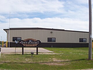
Calumet is a town in Fond du Lac County, Wisconsin, United States. The population was 1,514 at the 2000 census. The unincorporated communities of Artesia Beach, Calumet Harbor, Garnet, Highland Park, Johnsburg, Laudolff Beach, Marytown, Pipe, Pukwana Beach, Winnebago Heights, and Winnebago Park are located within the town. The unincorporated community of Calumetville is located partially in the town.

References

  1. "SD Towns" (PDF). South Dakota State Historical Society . Retrieved February 15, 2010.
  2. "ArcGIS REST Services Directory". United States Census Bureau. Retrieved October 15, 2022.
  3. 1 2 U.S. Geological Survey Geographic Names Information System: Pukwana, South Dakota
  4. 1 2 "Census Population API". United States Census Bureau. Retrieved October 15, 2022.
  5. 1 2 "U.S. Census website". United States Census Bureau . Retrieved January 31, 2008.
  6. "U.S. Census Bureau: Pukwana town, South Dakota". www.census.gov. United States Census Bureau. Retrieved June 27, 2022.
  7. Federal Writers' Project (1940). South Dakota place-names, v.1-3. University of South Dakota. p. 57.
  8. "Towns State Old-Fashioned Fight For Brule County's Courthouse," Lead Daily Call (UPI), September 21, 1955.
  9. "US Gazetteer files 2010". United States Census Bureau. Archived from the original on January 25, 2012. Retrieved June 21, 2012.
  10. "Census of Population and Housing". Census.gov. Retrieved June 4, 2015.
  11. "U.S. Census website". United States Census Bureau . Retrieved June 21, 2012.
  12. Climate Summary for Pukwana, South Dakota
  13. "Weatherbase.com". Weatherbase. 2013. Retrieved on October 13, 2013.