Pulaski, Illinois

Last updated

Pulaski
Pulaski-Commercial-block-il.jpg
Commercial Avenue
Pulaski County Illinois Incorporated and Unincorporated areas Pulaski Highlighted.svg
Location of Pulaski in Pulaski County, Illinois.
Illinois in United States (US48).svg
Location of Illinois in the United States
Coordinates: 37°13′0″N89°12′22″W / 37.21667°N 89.20611°W / 37.21667; -89.20611
CountryUnited States
StateIllinois
County Pulaski
Area
[1]
  Total1.32 sq mi (3.41 km2)
  Land1.31 sq mi (3.39 km2)
  Water0.01 sq mi (0.01 km2)
Elevation
[2]
335 ft (102 m)
Population
 (2020)
  Total154
  Density117.56/sq mi (45.40/km2)
Time zone UTC-6 (CST)
  Summer (DST) UTC-5 (CDT)
ZIP Code(s)
62976
Area code 618
FIPS code 17-62211
GNIS feature ID2399029 [2]
Wikimedia CommonsPulaski, Illinois

Pulaski is a village in Pulaski County, Illinois, United States. The population was 235 at the 2010 census. [3] The village is named in honor of Polish Revolutionary War hero Casimir Pulaski. [4]

Contents

History

Pulaski was founded in 1852 as a construction camp along the Illinois Central Railroad. A post office was established in 1856. The village was initially known as "Camp Pulaski," but the "Camp" was dropped from the name in 1872. Pulaski incorporated in 1898. [5]

Geography

Pulaski is located at 37°13′0″N89°12′22″W / 37.21667°N 89.20611°W / 37.21667; -89.20611 (37.216751, -89.206127). [6] The village lies in the Cache River basin north of Cairo. It straddles Old U.S. Highway 51 and is west of Interstate 57. Pulaski is west of the Ohio River.

According to the 2010 census, Pulaski has a total area of 1.316 square miles (3.41 km2), of which 1.31 square miles (3.39 km2) (or 99.54%) is land and 0.006 square miles (0.02 km2) (or 0.46%) is water. [7]

Demographics

Historical population
CensusPop.Note
1880 77
1900 424
1910 59239.6%
1920 518−12.5%
1930 5210.6%
1940 62319.6%
1950 478−23.3%
1960 415−13.2%
1970 47113.5%
1980 4771.3%
1990 361−24.3%
2000 274−24.1%
2010 206−24.8%
2020 154−25.2%
U.S. Decennial Census [8]

As of the census [9] of 2000, there were 274 people, 116 households, and 67 families residing in the village. The population density was 214.9 inhabitants per square mile (83.0/km2). There were 135 housing units at an average density of 105.9 per square mile (40.9/km2). The racial makeup of the village was 28.10% White, 70.80% African American, and 1.09% from two or more races.

There were 116 households, out of which 25.9% had children under the age of 18 living with them, 32.8% were married couples living together, 21.6% had a female householder with no husband present, and 41.4% were non-families. 37.1% of all households were made up of individuals, and 21.6% had someone living alone who was 65 years of age or older. The average household size was 2.36 and the average family size was 3.22.

In the village, the population was spread out, with 29.2% under the age of 18, 7.7% from 18 to 24, 22.6% from 25 to 44, 19.0% from 45 to 64, and 21.5% who were 65 years of age or older. The median age was 38 years. For every 100 females, there were 82.7 males. For every 100 females age 18 and over, there were 67.2 males.

The median income for a household in the village was $16,786, and the median income for a family was $28,250. Males had a median income of $29,444 versus $18,333 for females. The per capita income for the village was $12,946. About 26.5% of families and 32.9% of the population were below the poverty line, including 42.9% of those under the age of eighteen and 29.8% of those 65 or over.

Related Research Articles

<span class="mw-page-title-main">Pulaski County, Illinois</span> County in Illinois, United States

Pulaski County is a county located in the U.S. state of Illinois. According to the 2020 census, it had a population of 5,193. Its county seat is Mound City. Its largest city is Mounds. It is located along the Ohio River in the southwestern portion of the state, known locally as "Little Egypt".

<span class="mw-page-title-main">Camp Pendleton South, California</span> Census-designated place in California, United States

Camp Pendleton South is a census-designated place (CDP) in San Diego County, California, located at the southwest corner of the Marine Corps Base Camp Pendleton. The population was 10,616 at the 2010 census, up from 8,854 at the 2000 census. Much of the population are residents of Camp Pendleton barracks situated in the area, as well as housing communities for married Marine and Navy personnel and their families. It, along with Camp Pendleton Mainside CDP, is one of two CDPs on the base.

<span class="mw-page-title-main">Dalzell, Illinois</span> Village in Illinois, United States

Dalzell is a village in Bureau and LaSalle counties in the U.S. state of Illinois. The population was 663 at the 2020 census, down from 717 at the 2010 census. It is part of the Ottawa Micropolitan Statistical Area. Dalzell was founded on November 24, 1903, and certified on February 11, 1904.

<span class="mw-page-title-main">Campbell Hill, Illinois</span> Village in Illinois, United States

Campbell Hill is a village in Jackson County, Illinois, United States. The population was 309 at the 2020 census.

<span class="mw-page-title-main">Warrensburg, Illinois</span> Village in Illinois, United States

Warrensburg is a village in Macon County, Illinois, United States. Its population was 1,110 at the 2020 census, down from 1,201 in 2010. It is included in the Decatur, Illinois Metropolitan Statistical Area. Warrensburg was established in 1841.

<span class="mw-page-title-main">Modesto, Illinois</span> Village in Illinois, United States

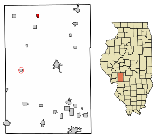
Modesto is a village in Macoupin County, Illinois, United States. The population was 182 at the 2020 census, down from 252 in 2000.

<span class="mw-page-title-main">Standard City, Illinois</span> Village in Illinois, United States

Standard City is a village in Macoupin County, Illinois, United States. The population was 135 at the 2020 census.

<span class="mw-page-title-main">Livingston, Illinois</span> Village in Illinois, United States

Livingston is a village in Madison County, Illinois, United States. The population was 763 at the 2020 census, down from 858 in 2010.

<span class="mw-page-title-main">St. Jacob, Illinois</span> Village in Illinois, United States

St. Jacob or Saint Jacob is a village in Madison County, Illinois, United States. The population was 1,358 at the 2020 census, up from 1,098 in 2010.

<span class="mw-page-title-main">Karnak, Illinois</span> Village in Illinois, United States

Karnak is a village in Pulaski County, Illinois, United States. The population was 499 at the 2010 census.

<span class="mw-page-title-main">Mound City, Illinois</span> City in Illinois, United States

Mound City is a city and the county seat of Pulaski County, Illinois, United States. It is located along the Ohio River just north of its confluence with the Mississippi River. As of the 2010 census, the city population was 588.

<span class="mw-page-title-main">Mounds, Illinois</span> City in Illinois, United States

Mounds is a city in Pulaski County, Illinois, United States. The population was 661 in the 2020 census.

<span class="mw-page-title-main">New Grand Chain, Illinois</span> Village in Illinois, United States

Grand Chain is a village in Pulaski County, Illinois, United States. The population was 190 at the 2010 census. The village's official name changed from "Grand Chain" to "New Grand Chain" in the 1970s, but its residents continue to refer to it as "Grand Chain."

<span class="mw-page-title-main">Olmsted, Illinois</span> Village in Illinois, United States

Olmsted is a village in Pulaski County, Illinois, along the Ohio River. The population was 299 at the 2000 census.

<span class="mw-page-title-main">Ullin, Illinois</span> Village in Illinois, United States

Ullin is a village in Pulaski County, Illinois, United States. The population was 463 at the 2010 census.

<span class="mw-page-title-main">Dongola, Illinois</span> Village in Illinois, United States

Dongola is a village in Union County, Illinois, United States. The population was 726 at the 2010 census.

<span class="mw-page-title-main">Bush, Illinois</span> Village in Illinois, United States

Bush is a village in Williamson County, Illinois, United States. As of the 2000 census, the village population was 257.

<span class="mw-page-title-main">Crainville, Illinois</span> Village in Illinois, United States

Crainville is a village in Williamson County, Illinois, United States. The population was 1,254 at the 2010 census.

<span class="mw-page-title-main">Neshkoro, Wisconsin</span> Village in Wisconsin, United States

Neshkoro is a village in Marquette County, Wisconsin, United States. The population was 434 at the 2010 census. The village is located within the Town of Neshkoro.

<span class="mw-page-title-main">Tunbridge Township, DeWitt County, Illinois</span> Township in Illinois, United States

Tunbridge Township is one of thirteen townships in DeWitt County, Illinois, USA. As of the 2020 census, its population was 751 and it contained 338 housing units.

References

  1. "2020 U.S. Gazetteer Files". United States Census Bureau. Retrieved March 15, 2022.
  2. 1 2 U.S. Geological Survey Geographic Names Information System: Pulaski, Illinois
  3. "ACS DEMOGRAPHIC AND HOUSING ESTIMATES". data.census.gov. Retrieved April 3, 2020.
  4. Illinois Central Magazine. Illinois Central Railroad Company. 1922. p. 42.
  5. Edward Callary, Place Names of Illinois (University of Illinois Press, 2010), pp. 287-288.
  6. "US Gazetteer files: 2010, 2000, and 1990". United States Census Bureau. February 12, 2011. Retrieved April 23, 2011.
  7. "G001 - Geographic Identifiers - 2010 Census Summary File 1". United States Census Bureau. Archived from the original on February 13, 2020. Retrieved December 25, 2015.
  8. "Census of Population and Housing". Census.gov. Retrieved June 4, 2015.
  9. "U.S. Census website". United States Census Bureau . Retrieved January 31, 2008.