Putnam County, Tennessee

Last updated

Putnam County
Putnam-County-Courthouse-tn1.jpg
Putnam County Courthouse
Putnam County, TN logo.png
Map of Tennessee highlighting Putnam County.svg
Location within the U.S. state of Tennessee
Tennessee in United States.svg
Tennessee's location within the U.S.
Coordinates: 36°08′N85°30′W / 36.14°N 85.5°W / 36.14; -85.5
CountryFlag of the United States.svg United States
StateFlag of Tennessee.svg  Tennessee
FoundedFebruary 11, 1854
Named for Israel Putnam [1]
Seat Cookeville
Largest cityCookeville
Government
   County executive Randy Porter (R) [2] [3]
Area
  Total403 sq mi (1,040 km2)
  Land401 sq mi (1,040 km2)
  Water1.5 sq mi (4 km2)  0.4%
Population
 (2020)
  Total79,854 Increase2.svg
  Density200/sq mi (80/km2)
Time zone UTC−6 (Central)
  Summer (DST) UTC−5 (CDT)
ZIP Codes
38501, 38502, 38503, 38505, 38506, 38544, 38545, 38548, 39574, 38582
Area code 931
Congressional district 6th
Website putnamcountytn.gov

Putnam County is a county located in the U.S. state of Tennessee. As of the 2020 census, the population was 79,854. [4] Its county seat is Cookeville. [5] Putnam County is part of the Cookeville, TN Micropolitan Statistical Area.

Contents

History

Putnam County is named in honor of Israel Putnam, who was a hero in the French and Indian War and a general in the American Revolutionary War. The county was initially established on February 2, 1842, when the Twenty-fourth Tennessee General Assembly enacted a measure creating the county from portions of Jackson, Overton, Fentress, and White counties. [1]

After the survey was completed by Mounce Gore, the Assembly instructed the commissioners to locate the county seat, to be called "Monticello," near the center of the county. Contending, however, that the formation of Putnam was illegal because it reduced their areas below constitutional limits, Overton and Jackson counties secured an injunction against its continued operation. Putnam officials failed to reply to the complaint, and in the March 1845 term of the Chancery Court at Livingston, Chancellor Bromfield L. Ridley declared Putnam unconstitutionally established and therefore dissolved. The 1854 act reestablishing Putnam was passed after Representative Henderson M. Clements of Jackson County assured his colleagues that a new survey showed that there was sufficient area to form the county. White Plains, near modern Algood, acted as a temporary county seat. [6]

The act specified the "county town" be named "Cookeville" in honor of Richard F. Cooke, who served in the Tennessee Senate from 1851 to 1854, representing at various times Jackson, Fentress, Macon, Overton and White Counties. The act authorized Joshua R. Stone and Green Baker from White County, William Davis and Isaiah Warton from Overton County, John Brown and Austin Morgan from Jackson County, William B. Stokes and Bird S. Rhea from DeKalb County, and Benjamin A. Vaden and Nathan Ward from Smith County, to study the Conner survey and select a spot, not more than two and one-half miles from the center of the county, for the courthouse. The first County Court chose a hilly tract of land, then owned by Charles Crook, for the site.

Putnam County was the site of several saltpeter mines. Saltpeter is the main ingredient of gunpowder and was obtained by leaching the earth from several local caves. Calfkiller Saltpeter Cave, located in the Calfkiller Valley, was a major mining operation, as was Johnson Cave, also located in the Calfkiller Valley. Both caves still contain significant remnants of the mining activity. Several other caves in the county were the site of smaller operations. Most saltpeter mining in Middle Tennessee occurred during the War of 1812 and the Civil War. [7]

Geography

Farm in rural northern Putnam County Farm-gate-putnam-tn1.jpg
Farm in rural northern Putnam County
Burgess Falls near the southern border with White County Burgess Falls (935955560).jpg
Burgess Falls near the southern border with White County

According to the U.S. Census Bureau, the county has a total area of 403 square miles (1,040 km2), of which 401 square miles (1,040 km2) is land and 1.5 square miles (3.9 km2) (0.4%) is water. [8]

The county is part of the greater Cumberland River watershed. The southern part of the county is drained by tributaries of the Caney Fork, the northeastern part by tributaries of the Obey River, and the north-central and northwestern parts of the county drain into the Cumberland's Cordell Hull Lake impoundment. [9] The sources of two tributaries of the Caney Fork, the Falling Water River and the Calfkiller River, lie near Monterey in the eastern part of the county.

Adjacent counties

State protected areas

Demographics

Historical population
CensusPop.Note
1860 8,558
1870 8,6981.6%
1880 11,50132.2%
1890 13,68319.0%
1900 16,89023.4%
1910 20,02318.5%
1920 22,23111.0%
1930 23,7596.9%
1940 26,25010.5%
1950 29,86913.8%
1960 29,236−2.1%
1970 35,48721.4%
1980 47,69034.4%
1990 51,3737.7%
2000 62,31521.3%
2010 72,32116.1%
2020 79,85410.4%
U.S. Decennial Census [10]
1790-1960 [11] 1900-1990 [12]
1990-2000 [13] 2010-2014 [4]
Age pyramid Putnam County USA Putnam County, Tennessee.csv age pyramid.svg
Age pyramid Putnam County

2020 census

Putnam County racial composition [15]
RaceNumberPercentage
White (non-Hispanic)66,78283.63%
Black or African American (non-Hispanic)2,1612.71%
Native American 1610.2%
Asian 1,0861.36%
Pacific Islander 330.04%
Other/Mixed 3,3754.23%
Hispanic or Latino 6,2567.83%

As of the 2020 United States census, there were 79,854 people, 31,778 households, and 19,395 families residing in the county.

2010 census

As of the census [16] of 2010, there were 72,321 people, 28,930 households, and 18,489 families residing in the county. The population density was 181 people per square mile (70 people/km2). There were 31,882 housing units at an average density of 80 per square mile (31/km2). The racial makeup of the county was 92.0% White, 2.0% Black or African American, 0.4% Native American, 1.2% Asian, 0.1% Pacific Islander, 2.8% from other races, and 1.5% from two or more races. 5.3% of the population were Hispanic or Latino of any race.

There were 28,930 households, out of which 26.3% had children under the age of 18 living with them, 52.70% were married couples living together, 9.80% had a female householder with no husband present, and 34.00% were non-families. 27.10% of all households were made up of individuals, and 10% had someone living alone who was 65 years of age or older. The average household size was 2.41 and the average family size was 2.94.

In the county, the population was spread out, with 22.30% under the age of 18, 14.70% from 18 to 24, 27.90% from 25 to 44, 21.90% from 45 to 64, and 13.20% who were 65 years of age or older. The median age was 34 years. For every 100 females, there were 98.40 males. For every 100 females age 18 and over, there were 96.70 males.

The median income for a household in the county was $33,092, and the median income for a family was $39,553. Males had a median income of $29,243 versus $21,001 for females. The per capita income for the county was $18,892. About 10.30% of families and 16.40% of the population were below the poverty line, including 15.90% of those under age 18 and 16.10% of those age 65 or over.

According to the US Census for 2013 Putnam County has the highest wealth inequality of any United States county with a population of over 65,000. [17]

Education

The Laboratory Science Commons at Tennessee Tech Laboratory-Science-Commons-se-TTU.jpg
The Laboratory Science Commons at Tennessee Tech

Cookeville, the largest town in Putnam County, is the home of Tennessee Technological University, which is known for its College of Education's undergraduate and graduate programs, its Engineering program's rigor, its College of Business alumni success, and the creativity of the College of Arts and Sciences. The largest college at Tennessee Tech is the College of Education. The university student population of 11,800 comprises one fourth of the resident population of Cookeville. [18]

The Putnam County school system enrolls approximately 12,000 students in 18 schools throughout the county. All schools are accredited. Cookeville High School is the largest non-metropolitan school in the state and is one of only eight high schools in the state to offer the International Baccalaureate program.[ citation needed ]

Communities

Cookeville Cookeville-Depot-Cream-City-tn2.jpg
Cookeville

Cities

Towns

Unincorporated communities

Politics

Putnam County is extremely conservative for a county anchored by a college town (Cookeville, the county seat, is home to Tennessee Technological University). In the 2020 United States presidential election, the Democratic presidential nominee, Joe Biden, won less than 28% of the vote while Donald Trump, the Republican nominee, won over 70% of the vote.

United States presidential election results for Putnam County, Tennessee [19]
Year Republican Democratic Third party
No.%No.%No.%
2020 23,75970.73%9,18527.34%6491.93%
2016 19,00269.83%6,85125.18%1,3594.99%
2012 17,25467.66%7,80230.60%4441.74%
2008 17,10162.60%9,73935.65%4761.74%
2004 15,63759.14%10,56639.96%2390.90%
2000 11,24850.13%10,78548.07%4051.80%
1996 9,09343.53%10,04748.10%1,7488.37%
1992 7,99837.23%10,85850.54%2,62612.22%
1988 9,54758.62%6,60640.56%1320.81%
1984 8,99954.40%7,44345.00%990.60%
1980 6,23542.26%8,08454.80%4342.94%
1976 4,07932.10%8,48566.77%1441.13%
1972 6,03860.39%3,73837.38%2232.23%
1968 3,69335.83%3,54134.36%3,07329.81%
1964 2,99332.18%6,30967.82%00.00%
1960 4,24048.65%4,44350.98%320.37%
1956 3,49243.63%4,48155.98%310.39%
1952 3,18343.73%4,09656.27%00.00%
1948 1,87933.77%3,13456.33%5519.90%
1944 1,77038.83%2,78861.17%00.00%
1940 1,57634.68%2,96365.21%50.11%
1936 1,20731.50%2,61968.35%60.16%
1932 1,28130.40%2,91169.08%220.52%
1928 1,61242.91%2,14557.09%00.00%
1924 1,48937.06%2,47461.57%551.37%
1920 2,13241.58%2,99658.42%00.00%
1916 1,38337.51%2,30062.38%40.11%
1912 92329.02%1,86758.69%39112.29%

See also

Related Research Articles

<span class="mw-page-title-main">Wilson County, Tennessee</span> County in Tennessee, United States

Wilson County is a county in the U.S. state of Tennessee. It is in Middle Tennessee. As of the 2020 census, the population was 147,737. Its county seat is Lebanon. The largest city is Mt. Juliet. Wilson County is part of the Nashville-Davidson–Murfreesboro–Franklin, TN Metropolitan Statistical Area.

<span class="mw-page-title-main">White County, Tennessee</span> County in Tennessee, United States

White County is a county located in the U.S. state of Tennessee. As of the 2020 census, the population was 27,351. Its county seat is Sparta.

<span class="mw-page-title-main">Warren County, Tennessee</span> County in Tennessee, United States

Warren County is a county located on the Cumberland Plateau in Middle Tennessee, one of the three Grand Divisions of the U.S. state of Tennessee. As of the 2020 census, the population was 40,953. Its county seat is McMinnville. Warren County comprises the McMinnville, TN Micropolitan Statistical Area.

<span class="mw-page-title-main">Van Buren County, Tennessee</span> County in Tennessee, United States

Van Buren County is a county located in the U.S. state of Tennessee. As of the 2020 census, the population was 6,168, making it the second-least populous county in Tennessee. Its county seat is Spencer.

<span class="mw-page-title-main">Smith County, Tennessee</span> County in Tennessee, United States

Smith County is a county in the U.S. state of Tennessee. As of the 2020 census, the population was 19,904. Smith County is located in the region of the state known as Middle Tennessee. Its county seat is Carthage. The county was organized in 1799 and is named for Daniel Smith, a Revolutionary War veteran who made the first map of Tennessee and served as a United States senator.

<span class="mw-page-title-main">Pickett County, Tennessee</span> County in Tennessee, United States

Pickett County is a county located in the U.S. state of Tennessee. As of the 2020 census, the population was 5,001, making it the least populous county in Tennessee. Its county seat is Byrdstown. The city of Byrdstown and the Kentucky town of Albany, 11 miles (18 km) to the northeast, are positioned between two Army Corps of Engineers lakes: Dale Hollow Lake, mainly in Tennessee, and Lake Cumberland, in Kentucky. The area is known as "Twin Lakes" and Byrdstown is noted as "The Gateway To Dale Hollow Lake". Every year thousands of people vacation at the many resorts situated along the lakes.

<span class="mw-page-title-main">Overton County, Tennessee</span> County in Tennessee, United States

Overton County is a county located in the U.S. state of Tennessee. As of the 2020 census, the population was 22,511. Its county seat is Livingston. Overton County is part of the Cookeville, TN Micropolitan Statistical Area.

<span class="mw-page-title-main">Jackson County, Tennessee</span> County in Tennessee, United States

Jackson County is a county located in the U.S. state of Tennessee. The population was 11,617 at the 2020 census. Its county seat is Gainesboro. Jackson is part of the Cookeville Micropolitan Statistical Area.

<span class="mw-page-title-main">Grundy County, Tennessee</span> County in Tennessee, United States

Grundy County is a county located in the U.S. state of Tennessee. It is located in Middle Tennessee, bordering East Tennessee. As of 2021, the population was 13,622. Its county seat is Altamont. The county is named in honor of Felix Grundy.

<span class="mw-page-title-main">Fentress County, Tennessee</span> County in Tennessee, United States

Fentress County is a county located in the U.S. state of Tennessee. As of the 2020 census, the population was 18,489. Its county seat is Jamestown.

<span class="mw-page-title-main">DeKalb County, Tennessee</span> County in Tennessee, United States

DeKalb County is a county located in the U.S. state of Tennessee. As of the 2020 census, the population was 20,080. Its county seat is Smithville. The county was created by the General Assembly of Tennessee on December 2, 1837, and was named for Revolutionary War hero Major General Johann de Kalb.

<span class="mw-page-title-main">Cumberland County, Tennessee</span> County in Tennessee, United States

Cumberland County is a county located in the U.S. state of Tennessee. As of the 2020 census, the population was 61,145. Its county seat is Crossville. Cumberland County comprises the Crossville, TN micropolitan statistical area.

<span class="mw-page-title-main">Jamestown, Tennessee</span> City in Tennessee, United States

Jamestown is a city in and the county seat of Fentress County, Tennessee, United States. The population of the city was 1,959 at the 2010 census.

<span class="mw-page-title-main">Gainesboro, Tennessee</span> Town in Tennessee, United States

Gainesboro is a town in Jackson County, Tennessee, United States. The population was 920 at the 2020 census. It is the county seat of Jackson County.

<span class="mw-page-title-main">Livingston, Tennessee</span> Town in Tennessee, United States

Livingston is a town in Overton County, Tennessee, United States, and serves as the county seat. The population was 3,905 at the 2020 census and 4,058 at the 2010 census. The current mayor, Curtis Hayes, began serving his mayoral position in September 2006.

<span class="mw-page-title-main">Algood, Tennessee</span> City in Tennessee, United States

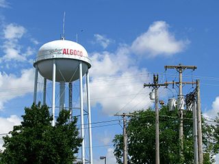
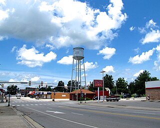
Algood is a city in Putnam County, Tennessee, United States. The population was 3,963 at the 2020 census. It is part of the Cookeville Micropolitan Statistical Area.

<span class="mw-page-title-main">Cookeville, Tennessee</span> Largest city and county seat of Putnam County, Tennessee, United States

Cookeville is the county seat and largest city of Putnam County, Tennessee, United States. As of the 2020 United States census, its population was reported to be 34,842. It is recognized as one of the country's micropolitan areas, or smaller cities which function as significant regional economic hubs. Of the twenty micropolitan areas in Tennessee, Cookeville is the largest. The Cookeville micropolitan area's 2010 Census population was 106,042. The U.S. Census Bureau ranked the Cookeville micropolitan area as the 7th largest-gaining micropolitan area in the country between 2018 and 2019, with a one-year gain of 1,796 and a 2019 population of 114,272. The city is a college town, home to Tennessee Tech.

<span class="mw-page-title-main">Monterey, Tennessee</span> Town in Tennessee, United States

Monterey is a town in Putnam County, Tennessee, United States. The population was 2,850 at the 2010 census. It is part of the Cookeville, Tennessee Micropolitan Statistical Area.

<span class="mw-page-title-main">Sparta, Tennessee</span> City in Tennessee, United States

Sparta is a city in and the county seat of White County, Tennessee, United States. The population was 5,001 in 2020.

<span class="mw-page-title-main">Cookeville micropolitan area</span> Micropolitan statistical area in Tennessee, United States

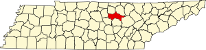
The Cookeville Micropolitan Statistical Area as defined by the United States Census Bureau, is an area consisting of four counties in central Tennessee, anchored by the city of Cookeville.

References

  1. 1 2 Blythe Semmer, "Putnam County," Tennessee Encyclopedia of History and Culture. Retrieved: March 20, 2013.
  2. "Putnam". County Technical Assistance Service. University of Tennessee . Retrieved October 5, 2020.
  3. "Putnam County Election Results August 2, 2018". Putnam County, Tennessee. Retrieved October 5, 2020.
  4. 1 2 "State & County QuickFacts". United States Census Bureau. Archived from the original on August 20, 2011. Retrieved December 7, 2013.
  5. "Find a County". National Association of Counties. Retrieved June 7, 2011.
  6. Randal William, National Register of Historic Places Nomination Form for White Plains [ permanent dead link ]. Retrieved: September 27, 2009.
  7. Thomas C. Barr, Jr., "Caves of Tennessee", Bulletin 64 of the Tennessee Division of Geology, 1961.
  8. "2010 Census Gazetteer Files". United States Census Bureau. August 22, 2012. Retrieved April 9, 2015.
  9. Tennessee Department of Environment and Conservation, Watershed Management Approach Archived April 17, 2012, at the Wayback Machine . Retrieved: May 10, 2012.
  10. "U.S. Decennial Census". United States Census Bureau. Retrieved April 9, 2015.
  11. "Historical Census Browser". University of Virginia Library. Archived from the original on August 11, 2012. Retrieved April 9, 2015.
  12. Forstall, Richard L., ed. (March 27, 1995). "Population of Counties by Decennial Census: 1900 to 1990". United States Census Bureau. Retrieved April 9, 2015.
  13. "Census 2000 PHC-T-4. Ranking Tables for Counties: 1990 and 2000" (PDF). United States Census Bureau. April 2, 2001. Retrieved April 9, 2015.
  14. Based on 2000 census data
  15. "Explore Census Data". data.census.gov. Retrieved December 27, 2021.
  16. "U.S. Census website". United States Census Bureau . Retrieved May 14, 2011.
  17. Cohn, Emily (September 23, 2014). "'Here Are the Most Unequal Counties in America'". Huffington Post. Retrieved October 16, 2019.[ permanent dead link ]
  18. "U.S. Census Bureau QuickFacts: Cookeville city, Tennessee". Census.gov. Retrieved July 20, 2022.
  19. Leip, David. "Dave Leip's Atlas of U.S. Presidential Elections". uselectionatlas.org. Retrieved March 12, 2018.

36°08′N85°30′W / 36.14°N 85.50°W / 36.14; -85.50