Putney, Georgia

Last updated

Putney, Georgia
Dougherty County Georgia Incorporated and Unincorporated areas Putney Highlighted.svg
Location in Dougherty County and the state of Georgia
Usa edcp location map.svg
Red pog.svg
Putney, Georgia
Location within the United States
Coordinates: 31°28′23″N84°7′17″W / 31.47306°N 84.12139°W / 31.47306; -84.12139
Country United States
State Georgia
County Dougherty
Area
[1]
  Total22.13 sq mi (57.31 km2)
  Land22.02 sq mi (57.03 km2)
  Water0.11 sq mi (0.28 km2)
Elevation
200 ft (61 m)
Population
 (2020)
  Total2,869
  Density130.28/sq mi (50.30/km2)
Time zone UTC-5 (Eastern (EST))
  Summer (DST) UTC-4 (EDT)
ZIP code
31782
Area code 229
FIPS code 13-63084 [2]
GNIS feature ID0332767 [3]

Putney is an unincorporated community and census-designated place (CDP) in Dougherty County, Georgia, United States. The population was 2,898 at the 2010 census. [4] It is part of the Albany, Georgia Metropolitan Statistical Area.

Contents

History

A post office called Putney was established in 1897. [5] The community was named after Francis F. Putney, a local landowner. [6]

Geography

Putney is located in southeastern Dougherty County at 31°28′23″N84°7′17″W / 31.47306°N 84.12139°W / 31.47306; -84.12139 (31.473076, -84.121492). [7] The southern border of the CDP is the Mitchell County line, and part of the western edge is the Flint River. U.S. Route 19 (the Liberty Expressway) is the main highway through Putney, leading north 7 miles (11 km) to Albany and south 50 miles (80 km) to Thomasville.

According to the United States Census Bureau, the Putney CDP has a total area of 21.9 square miles (56.8 km2), of which 21.9 square miles (56.6 km2) is land and 0.1 square miles (0.3 km2), or 0.49%, is water. [4]

Demographics

Historical population
CensusPop.Note
1990 3,108
2000 2,998−3.5%
2010 2,898−3.3%
2020 2,869−1.0%
U.S. Decennial Census [8]

As of the census [2] of 2000, there were 2,998 people, 1,138 households, and 899 families residing in the CDP. The population density was 139.6 inhabitants per square mile (53.9/km2). There were 1,223 housing units at an average density of 56.9 units per square mile (22.0 units/km2). The racial makeup of the CDP was 68.81% White, 29.52% African American, 0.13% Native American, 0.23% Asian, 0.50% from other races, and 0.80% from two or more races. Hispanic or Latino of any race were 1.00% of the population.

There were 1,138 households, out of which 31.8% had children under the age of 18 living with them, 59.7% were married couples living together, 14.8% had a female householder with no husband present, and 21.0% were non-families. 17.2% of all households were made up of individuals, and 5.4% had someone living alone who was 65 years of age or older. The average household size was 2.63 and the average family size was 2.96.

In the CDP, the population was spread out, with 24.4% under the age of 18, 8.3% from 18 to 24, 26.5% from 25 to 44, 28.5% from 45 to 64, and 12.3% who were 65 years of age or older. The median age was 39 years. For every 100 females, there were 96.8 males. For every 100 females age 18 and over, there were 93.8 males.

The median income for a household in the CDP was $40,953, and the median income for a family was $44,244. Males had a median income of $35,377 versus $21,910 for females. The per capita income for the CDP was $18,828. About 12.8% of families and 16.8% of the population were below the poverty line, including 26.9% of those under age 18 and 11.9% of those age 65 or over.

Neighborhoods

Related Research Articles

<span class="mw-page-title-main">Lake Isabella, California</span> Census-designated place in California, United States

Lake Isabella is a census-designated place (CDP) in the southern Sierra Nevada, in Kern County, California, United States. It is named after the Lake Isabella reservoir and located at its southwestern edge, 6 miles (9.7 km) south of Wofford Heights in the Kern River Valley.

<span class="mw-page-title-main">Parkwood, California</span> Census-designated place in California, United States

Parkwood is a census-designated place (CDP) in Madera County, California, United States. It is part of the Madera Metropolitan Statistical Area. The population was 2,307 at the 2020 census.

<span class="mw-page-title-main">Kathleen, Florida</span> Census-designated place in Florida, United States

Kathleen is a census-designated place (CDP) in Polk County, Florida, United States. The population was 3,280 at the 2000 census. It is part of the Lakeland–Winter Haven Metropolitan Statistical Area.

<span class="mw-page-title-main">Fort Benning South, Georgia</span> CDP in Georgia, United States

Fort Benning South is a former census-designated place (CDP) in Chattahoochee County, Georgia, United States. It is part of the Columbus, Georgia-Alabama metropolitan statistical area. The population was 11,737 at last official census (2000). The area is now part of consolidated Cusseta–Chattahoochee County.

<span class="mw-page-title-main">Irondale, Georgia</span> Place in Georgia, United States

Irondale is an unincorporated community and census-designated place (CDP) in Clayton County, Georgia, United States. The population was 8,740 at the 2020 census.

<span class="mw-page-title-main">Vinings, Georgia</span> Place in Georgia, United States

Vinings is an unincorporated community and census-designated place (CDP) in Cobb County, Georgia, United States that runs along the Chattahoochee River bank across from Buckhead. As of the 2020 census, the CDP had a total population of 12,581. Located next to the affluent Paces section of Buckhead in northwest Atlanta, Vinings is known for its historic sites, shopping districts, proximity to local freeways and The Battery, and nearby nature areas. The United States Postal Service assigns "Atlanta" to the ZIP Code (30339) that includes Vinings.

<span class="mw-page-title-main">Belvedere Park, Georgia</span> Place in Georgia, United States

Belvedere Park is an unincorporated community and census-designated place (CDP) in DeKalb County, Georgia, United States. The population was 15,113 at the 2020 census.

<span class="mw-page-title-main">Gresham Park, Georgia</span> Place in Georgia, United States

Gresham Park is an unincorporated community and census-designated place (CDP) in DeKalb County, Georgia, United States. The population was 7,700 at the 2020 census.

<span class="mw-page-title-main">Redan, Georgia</span> Place in Georgia, United States

Redan is an unincorporated community and census-designated place (CDP) in DeKalb County, Georgia, United States. As of the 2020 census, the CDP had a total population of 31,749. It is a predominantly African American community in eastern DeKalb County, and is a suburb of Atlanta.

<span class="mw-page-title-main">Hilltop, Georgia</span> Place in Georgia, United States

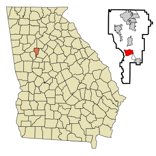
Hilltop is an unincorporated community and census-designated place (CDP) in Pike County, Georgia, United States. The population was 401 at the 2000 census.

<span class="mw-page-title-main">Experiment, Georgia</span> Place in Georgia, United States

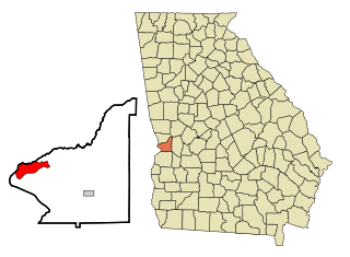
Experiment is an unincorporated community and census-designated place (CDP) in Spalding County, Georgia, United States. The population was 3,233 at the 2000 census.

<span class="mw-page-title-main">Sunset Village, Georgia</span> Place in Georgia, United States

Sunset Village is an unincorporated community and census-designated place (CDP) in Upson County, Georgia, United States. The population was 871 at the 2000 census.

<span class="mw-page-title-main">St. Leonard, Maryland</span> Census-designated place in Maryland

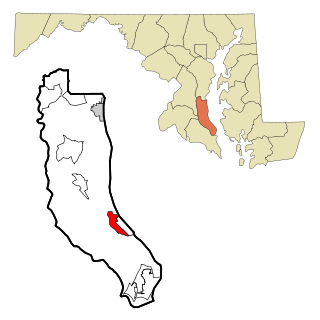
St. Leonard is a census-designated place (CDP) in Calvert County, Maryland, United States. The population was 742 at the 2010 census. Residents of the Calvert Beach and Long Beach communities also use the St. Leonard ZIP code designation.

<span class="mw-page-title-main">Littleton Common, Massachusetts</span> Census-designated place in Massachusetts, United States

Littleton Common is a census-designated place (CDP) in the town of Littleton in Middlesex County, Massachusetts, United States. The population was 3,065 at the 2020 census, up from 2,789 in 2010.

<span class="mw-page-title-main">Neffs, Ohio</span> Census-designated place in Ohio, United States

Neffs is an unincorporated community and census-designated place in northwestern Pultney Township, Belmont County, Ohio, United States. The population was 878 at the 2020 census. It is part of the Wheeling metropolitan area.

<span class="mw-page-title-main">Clearwater, South Carolina</span> Census-designated place in South Carolina, United States of America

Clearwater is a census-designated place (CDP) in Aiken County, South Carolina. It lies near North Augusta, South Carolina, and is part of the Augusta, Georgia metropolitan area. Clearwater is located in historic Horse Creek Valley. The population was 4,370 at the time of the 2010 census.

<span class="mw-page-title-main">Doolittle, Texas</span> Census-designated place in Texas

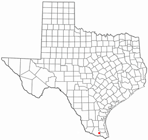
Doolittle is a census-designated place (CDP) in Hidalgo County, Texas, United States. The population was 4,061 at the 2020 United States Census. It is part of the McAllen–Edinburg–Mission Metropolitan Statistical Area.

<span class="mw-page-title-main">Markham, Texas</span> CDP in Texas, United States

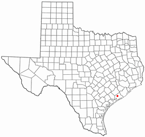
Markham is a census-designated place (CDP) in Matagorda County, Texas, United States. Named in 1903 for Charles H. Markham, a railroad engineer for Southern Pacific, the town was founded in 1901 as Cortes. In 1914, it was a designated stop on the Texas and New Orleans Railroad. As of the 2020 census, the population was 908.

<span class="mw-page-title-main">Switzer, West Virginia</span> Census-designated place in West Virginia, United States

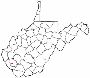
Switzer is an unincorporated community and census-designated place (CDP) in Logan County, West Virginia, United States. The CDP includes the neighboring unincorporated community of Micco. The total CDP population was 595 at the 2010 census.

Sweeney Ranch is an unincorporated community in Sweetwater County, Wyoming, United States. The population was 17 at the 2000 census, when it was a census-designated place (CDP).

References

  1. "2020 U.S. Gazetteer Files". United States Census Bureau. Retrieved December 18, 2021.
  2. 1 2 "U.S. Census website". United States Census Bureau . Retrieved January 31, 2008.
  3. "US Board on Geographic Names". United States Geological Survey. October 25, 2007. Retrieved January 31, 2008.
  4. 1 2 "Geographic Identifiers: 2010 Demographic Profile Data (G001): Putney CDP, Georgia". U.S. Census Bureau, American Factfinder. Retrieved October 23, 2015.[ dead link ]
  5. "Post Offices". Jim Forte Postal History. Retrieved May 25, 2019.
  6. Krakow, Kenneth K. (1975). Georgia Place-Names: Their History and Origins (PDF). Macon, GA: Winship Press. p. 182. ISBN   0-915430-00-2.
  7. "US Gazetteer files: 2010, 2000, and 1990". United States Census Bureau. February 12, 2011. Retrieved April 23, 2011.
  8. "Census of Population and Housing". Census.gov. Retrieved June 4, 2016.