Petrified Forest National Park is an American national park in Navajo and Apache counties in northeastern Arizona. Named for its large deposits of petrified wood, the park covers about 346 square miles, encompassing semi-desert shrub steppe as well as highly eroded and colorful badlands. The park's headquarters is about 26 miles (42 km) east of Holbrook along Interstate 40 (I-40), which parallels the BNSF Railway's Southern Transcon, the Puerco River, and historic U.S. Route 66, all crossing the park roughly east–west. The site, the northern part of which extends into the Painted Desert, was declared a national monument in 1906 and a national park in 1962. The park received 644,922 recreational visitors in 2018.

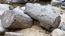
Petrified wood, also known as petrified tree, is the name given to a special type of fossilized wood, the fossilized remains of terrestrial vegetation. Petrifaction is the result of a tree or tree-like plants having been replaced by stone via a mineralization process that often includes permineralization and replacement. The organic materials making up cell walls have been replicated with minerals. In some instances, the original structure of the stem tissue may be partially retained. Unlike other plant fossils, which are typically impressions or compressions, petrified wood is a three-dimensional representation of the original organic material.
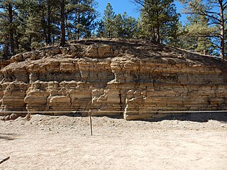
The Florissant Formation is a sedimentary geologic formation outcropping around Florissant, Teller County, Colorado. The formation is noted for the abundant and exceptionally preserved insect and plant fossils that are found in the mudstones and shales. Based on argon radiometric dating, the formation is Eocene in age and has been interpreted as a lake environment. The fossils have been preserved because of the interaction of the volcanic ash from the nearby Thirtynine Mile volcanic field with diatoms in the lake, causing a diatom bloom. As the diatoms fell to the bottom of the lake, any plants or animals that had recently died were preserved by the diatom falls. Fine layers of clays and muds interspersed with layers of ash form "paper shales" holding beautifully-preserved fossils. The Florissant Fossil Beds National Monument is a national monument established to preserve and study the geology and history of the area.

The Colorado Plateau, also known as the Colorado Plateau Province, is a physiographic and desert region of the Intermontane Plateaus, roughly centered on the Four Corners region of the southwestern United States. This province covers an area of 336,700 km2 (130,000 mi2) within western Colorado, northwestern New Mexico, southern and eastern Utah, northern Arizona, and a tiny fraction in the extreme southeast of Nevada. About 90% of the area is drained by the Colorado River and its main tributaries: the Green, San Juan, and Little Colorado. Most of the remainder of the plateau is drained by the Rio Grande and its tributaries.
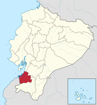
El Oro is the southernmost of Ecuador's coastal provinces. It was named for its historically important gold production. Today it is one of the world's major exporters of bananas. The capital is Machala.
Tumbes is a coastal department and region in northwestern Peru bordering Ecuador. Due to the region's location near the Equator it has a warm climate, with beaches that are considered among the finest in Peru. Despite its small area, the region contains a wide variety of ecosystems. It is the smallest department in Peru and its third least populous department after Moquegua and Madre de Dios, but it is also its third most densely populated department, after La Libertad and Lambayeque.
Loja Province is one of 24 provinces in Ecuador and shares its southern border on the west with El Oro Province, on the north with El Azuay, and on the east with Zamora-Chinchipe. Founded on its present site in 1548 by Captain Alonso de Mercadillo (Spanish), the site had been previously moved and rebuilt from La Toma due to earthquakes. It also is named as "Cuxibamba Valley", from the Quichua language, which means the "Smiley Valley".
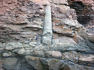
A polystrate fossil is a fossil of a single organism that extends through more than one geological stratum. The word polystrate is not a standard geological term. This term is typically found in creationist publications.
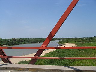
The Tumbes River, is a river in South America. The river's sources are located between Ecuadorian El Oro and Loja provinces. It is the border between El Oro and Loja, and afterwards the border between Loja and the Tumbes Region in Peru. At its confluence with the Cazaderos stream, it enters the northern coastal region of Peru called the Tumbes Region, and flows into the Pacific Ocean outside the Gulf of Guayaquil. The largest city on its banks is Tumbes, Peru.

Sigri is a small fishing village near the western tip of Lesbos Island. Its name derives through Greek σίγουρος from the Venetian word siguro, meaning "safe", based on the fact that it has a safe harbour. Sigri has a Turkish castle, built in 1746 during the Ottoman occupation, which looks over the bay and the long island of Nissiopi, which stretches across the mouth of the bay and acts as a buffer to the prevailing winds. The port of Sigri is able to accommodate large vessels, even cruise ship-size ferry boats coming from the mainline. Almost all shipping to Lesbos, however, comes into the east of the island.

The Gallatin Range is a mountain range of the Rocky Mountains, located in the U.S. states of Montana and Wyoming. It includes more than 10 mountains over 10,000 feet (3,000 m). The highest peak in the range is Electric Peak at 10,969 feet (3,343 m).
Alamor is the head of the Puyango canton, province of Loja, Ecuador.

The Paleontological and Paleobotanical Museum at Nostimo is an exhibition of fossils in a village in Western Macedonia, Greece. The village of Nostimo is 25 km from the city of Kastoria and 14 km from the town of Argos Orestiko.
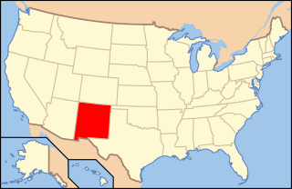
Paleontology in New Mexico refers to paleontological research occurring within or conducted by people from the U.S. state of New Mexico. The fossil record of New Mexico is exceptionally complete and spans almost the entire stratigraphic column. More than 3,300 different kinds of fossil organisms have been found in the state. Of these more than 700 of these were new to science and more than 100 of those were type species for new genera. During the early Paleozoic, southern and western New Mexico were submerged by a warm shallow sea that would come to be home to creatures including brachiopods, bryozoans, cartilaginous fishes, corals, graptolites, nautiloids, placoderms, and trilobites. During the Ordovician the state was home to algal reefs up to 300 feet high. During the Carboniferous, a richly vegetated island chain emerged from the local sea. Coral reefs formed in the state's seas while terrestrial regions of the state dried and were home to sand dunes. Local wildlife included Edaphosaurus, Ophiacodon, and Sphenacodon.

Paleontology in Arizona refers to paleontological research occurring within or conducted by people from the U.S. state of Arizona. The fossil record of Arizona dates to the Precambrian. During the Precambrian, Arizona was home to a shallow sea which was home to jellyfish and stromatolite-forming bacteria. This sea was still in place during the Cambrian period of the Paleozoic era and was home to brachiopods and trilobites, but it withdrew during the Ordovician and Silurian. The sea returned during the Devonian and was home to brachiopods, corals, and fishes. Sea levels began to rise and fall during the Carboniferous, leaving most of the state a richly vegetated coastal plain during the low spells. During the Permian, Arizona was richly vegetated but was submerged by seawater late in the period.
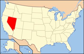
Paleontology in Nevada refers to paleontological research occurring within or conducted by people from the U.S. state of Nevada. Nevada has a rich fossil record of plants and animal life spanning the past 650 million years of time. The earliest fossils from the state are from Esmeralda County, and are Late Proterozoic in age and represent stromatolite reefs of cyanobacteria, amongst these reefs were some of the oldest known shells in the fossil record, the Cloudina-fauna. Much of the Proterozoic and Paleozoic fossil story of Nevada is that of a warm, shallow, tropical sea, with a few exceptions towards the Late Paleozoic. As such many fossils across the state are those of marine animals, such as trilobites, brachiopods, bryozoans, honeycomb corals, archaeocyaths, and horn corals.

The Chemnitz petrified forest is a petrified forest in Chemnitz, Germany.
Ecuador is a country with vast natural and cultural wealth. The diversity of its four regions has resulted in hundreds of thousands of species of flora and fauna. It has about 1640 species of birds. The species of butterflies line the 4,500, the 345 reptiles, 358 amphibians and 258 mammals, among others. Ecuador is considered one of the 17 countries where the greatest biodiversity of the planet is concentrated. Most of its flora and fauna live in 26 areas protected by the State. It also offers historical attractions such as Quito, food and a variety of cultures and traditions.

The Ecuadorian dry forests (NT0214) is an ecoregion near the Pacific coast of the Ecuador. The habitat has been occupied by people for centuries and has been severely damaged by deforestation, overgrazing and hillside erosion due to unsustainable agriculture. Only 1% of the original forest remains. The patches of forest, mostly secondary growth, are fragmented. They are home to many endemic species at risk of extinction.
Akal Wood Fossil Park is a National Geological Monument of India located in Jaisalmer district, Rajasthan. It is also a Biodiversity Heritage Site.