Qoriyoley | |
|---|---|
 | |
| Country | |
| Region | Lower Shabelle |
| Capital | Qoryoley |
| Time zone | UTC+3 (EAT) |

Qoriyoley District (Somali : Degmada Qoriyoley) is a district in the southeastern Lower Shabelle (Shabeellaha Hoose) region of Somalia. Its capital is Qoryoley.
Qoriyoley | |
|---|---|
| | |
| Country | |
| Region | Lower Shabelle |
| Capital | Qoryoley |
| Time zone | UTC+3 (EAT) |
Qoriyoley District (Somali : Degmada Qoriyoley) is a district in the southeastern Lower Shabelle (Shabeellaha Hoose) region of Somalia. Its capital is Qoryoley.

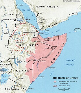
Somalia, officially the Federal Republic of Somalia, is a country in the Horn of Africa. The country is bordered by Ethiopia to the west, Djibouti to the northwest, the Gulf of Aden to the north, the Indian Ocean to the east, and Kenya to the southwest. Somalia has the longest coastline on Africa's mainland. Its terrain consists mainly of plateaus, plains, and highlands. Hot conditions prevail year-round, with periodic monsoon winds and irregular rainfall. Somalia has an estimated population of around 15 million, of which over 2 million live in the capital and largest city Mogadishu, and has been described as Africa's most culturally homogeneous country. Around 85% of its residents are ethnic Somalis, who have historically inhabited the country's north. Ethnic minorities are largely concentrated in the south. The official languages of Somalia are Somali and Arabic. Most people in the country are Muslims, the majority of them Sunni.
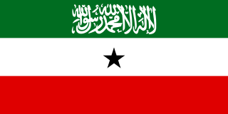
Somaliland, officially the Republic of Somaliland, is a de facto sovereign state in the Horn of Africa, considered by most states to be part of Somalia. Somaliland lies in the Horn of Africa, on the southern coast of the Gulf of Aden. It is bordered by Djibouti to the northwest, Ethiopia to the south and west, and Somalia to the east. Its claimed territory has an area of 176,120 square kilometres (68,000 sq mi), with approximately 5.7 million residents as of 2021. The capital and largest city is Hargeisa. The government of Somaliland regards itself as the successor state to British Somaliland, which, as the briefly independent State of Somaliland, united in 1960 with the Trust Territory of Somaliland to form the Somali Republic.
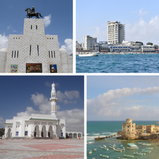
Mogadishu, locally known as Xamar or Hamar, is the capital city and most populous city of Somalia. The city has served as an important port connecting with traders all round the Indian Ocean for millennia and has an estimated population of 2,388,000 (2021). Mogadishu is located in the coastal Banadir region on the Indian Ocean, which unlike other Somali regions, is considered a municipality rather than a maamul goboleed.

Sanag is an administrative region (gobol) in north eastern Somaliland. Sanaag has a long coastline facing the Gulf of Aden to the north, and is bordered by the region of Sahil to the west, Sool to the south and Somalia to the east. Its capital city is Erigavo. Sanaag is the largest region of Somaliland, accounting for 35% of Somaliland's total land area.

Marodi Jeh is an administrative region (gobol) in western Somaliland. It is considered to be the most populous region of the country. It is bordered by Awdal to the west, Sahil to the north, Togdheer to the east and Ethiopia to the south. Marodi Jeh was created by splitting the previously existing region (gobolka) Woqooyi Galbeed in two, the other part being Sahil. In 2007 the region of Woqooyi Galbeed was renamed to Maroodi Jeex. Woqooyi Galbeed was thus much larger than Marodi Jeh.

Bari is an administrative region (gobol) in northern Somalia.

Mudug is an administrative region (gobol) in north-central Somalia. The population of Mudug is 131,455 as of 2005.

Galguduud is an administrative region (gobol) of Galmudug state in central Somalia. Its administrative capital is Dusmareb.

Bakool is a region (gobol) in southwestern Somalia.

Lower Shabelle is an administrative region (gobol) in southern Somalia.

Banaadir is an administrative region (gobol) in southeastern Somalia. It covers the same area as the city of Mogadishu, which serves as the capital. It is bordered to the northwest by the Shabelle river, and to the southeast by the Indian Ocean. Although by far the smallest administrative region in Somalia, it has the largest population, estimated at 3,650,227 in 2014.

Gedo is an administrative region (gobol) in Jubaland, southern Somalia. Its regional capital is Garbahaarreey. It was created in 1974 and is bordered by the Ogaden in Ethiopia, the North Eastern Province in Kenya, and the Somali regions of Bakool, Bay, Jubbada Dhexe, and Jubbada Hoose further down east. The southern parts of Gedo, west of the Jubba River, used to be part of the old British Trans-Juba region during half of the seventy years of colonial era in Africa from 1890 to 1960. The British and Italians fought twice over this area. The first democratically elected governor of the administrative region was Hussein Farey, who entered office in 2008.

Lower Juba is an administrative region (gobol) in southern Somalia. With its capital at Kismayo, it lies in the autonomous Jubaland region. It has green forests and wild life animals such as lions, giraffes, hippos, crocodiles, and hyenas.
Somali is an Afroasiatic language belonging to the Cushitic branch. It is spoken as a mother tongue by Somalis in Greater Somalia and the Somali diaspora. Somali is an official language of Somalia, Somaliland, and Ethiopia, and a national language in Djibouti as well in northeastern Kenya. The Somali language is written officially with the Latin alphabet although the Arabic alphabet and several Somali scripts like Osmanya and the Borama script are informally used.
The Somali Region, also known as Soomaali Galbeed is a regional state in eastern Ethiopia. Its territory is the largest after Oromia Region. The regional state borders the Ethiopian regions of Afar and Oromia and the chartered city Dire Dawa to the west, as well as Djibouti and Somaliland to the north, Somalia to the east and south; and Kenya to the southwest.
Greater Somalia is a concept to unite all ethnic Somalis comprising the regions in or near the Horn of Africa in which ethnic Somalis live and have historically inhabited. The territory historically encompassed British Somaliland, Italian Somaliland, French Somaliland, the Somali Region in Ethiopia and the Northern Frontier District in Kenya. At the present, it encompasses Somalia, Somaliland, southern Djibouti, the Somali Region and Dire Dawa in Ethiopia, and the Garissa, Wajir and Mandera Counties in Kenya.

The North Eastern Province is one of the former provinces in Kenya. It has a land area of 127,358.5 km2, with its capital at Garissa. Britain administration left the Northern Kenya to the control of Kenyan Government. It is and has been inhabited by most Kenyan ethnicities including ethnic Somalis.

Somalia is officially divided into 18 administrative regions. These are in turn subdivided into seventy-two districts
The Shifta War or gaf Daba (1963–1967) was a secessionist conflict in which ethnic Somalis in the Northern Frontier District (NFD) of Kenya attempted to secede from Kenya to join Somalia. The Kenyan government named the conflict "shifta", after the Somali word for "bandit", as part of a propaganda effort. The Kenyan counter-insurgency General Service Units forced civilians into "protected villages" as well as killing livestock kept by the pastoralist Somalis.

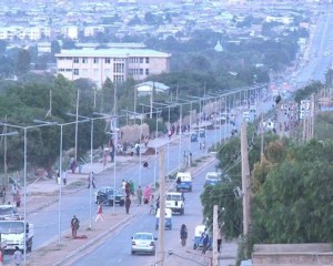
Qoryoley is a city in southern Somalia. It is located in the Lower Shebelle region.
| | This Somalia location article is a stub. You can help Wikipedia by expanding it. |