South San Francisco is a city in San Mateo County, California, United States, located on the San Francisco Peninsula in the San Francisco Bay Area. The city is colloquially known as "South City". The population was 66,105 at the 2020 census.

Sunnyvale is a city located in the Santa Clara Valley in northwest Santa Clara County in the U.S. state of California.

Russian Hill is a neighborhood of San Francisco, California. It is named after one of San Francisco's 44 hills, and one of its original "Seven Hills".

Pacific Heights is a neighborhood in San Francisco, California. It has panoramic views of the Golden Gate Bridge, San Francisco Bay, the Palace of Fine Arts, Alcatraz, and the Presidio.

Cathedral Hill is a neighborhood and a hill, in the Western Addition district of San Francisco, California.
Ghost Town is the informal name of the Hoover-Foster Historic District neighborhood in West Oakland, Oakland, California.

Hotel Union Square is located at 114 Powell Street in San Francisco, California. It was built in 1908, had a speakeasy in the basement during the Prohibition Era, and Dashiell Hammett was a patron.

The Treasure Island Development is a 405-acre (164 ha) major redevelopment project under construction on Treasure Island and parts of Yerba Buena Island in San Francisco Bay between San Francisco and Oakland, within San Francisco city limits. The Treasure Island Development Authority (TIDA) is a nonprofit organization formed to oversee the economic development of the former naval station. Treasure Island's development was set to break ground during mid-2012. However, on April 12, 2013, The San Francisco Chronicle reported that the deal has collapsed, with the Chinese investors from China Development Bank and China Railway Construction Corporation withdrawing from the project. The Treasure Island Project is being developed by a joint venture between Lennar and Kenwood Investments. The development is expected to cost US$1.5 billion.

Castro Camera was a camera store in the Castro District of San Francisco, California, operated by Harvey Milk from 1972 until his assassination in 1978. During the 1970s the store became the center of the neighborhood's growing gay community, as well as campaign headquarters for Milk's various campaigns for elected office.

Preservation Park is located in Oakland, California. The park includes sixteen historic buildings, five of which stand in their original location, and eleven of which were moved from elsewhere in Oakland to avoid demolition. The sixteen houses are arranged to resemble a late 19th-century Oakland neighborhood.

The Tonga Room & Hurricane Bar is a restaurant and tiki bar in the Fairmont San Francisco hotel in San Francisco, California. Named after the South Pacific nation of Tonga, this dining and entertainment venue opened in 1945. The Tonga Room replaced the Terrace Plunge, an indoor swimming pool that was installed in the Fairmont in 1929. The pool was transformed into the Tonga Room's lagoon. The restaurant was redesigned again in 1967.
The following are reportedly haunted locations in California, in the United States. This list is sorted by county.

San Francisco and Oakland Helicopter Airlines was a helicopter airline service offering scheduled passenger flights between San Francisco, Oakland, and other Bay Area cities. It was founded in 1961 but disappeared from the Official Airline Guide 15 years later before finally going out of business in 1986.
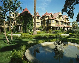
There are many reportedly haunted locations in San Francisco, California. According to ghost hunters, over 100 sites in the San Francisco Bay Area are reported to be haunted.

New Montgomery Street, formerly Montgomery Street South, begins at Market Street and terminates at Howard Street in the SOMA district of San Francisco, California.

Jackson Street is a street in San Francisco, California, running through the Pacific Heights, Nob Hill, Chinatown and Jackson Square districts of the city. It runs between Pacific Avenue and Washington Street, beginning at Arguello Boulevard to the south of the Presidio Golf Course and ending at Drumm Street, to the west of Pier 3, near Sydney G. Walton Square.

Nob Hill is a neighborhood of San Francisco, California, United States that is known for its numerous luxury hotels and historic mansions. Nob Hill has historically served as a center of San Francisco's upper class. Nob Hill is among the highest-income neighborhoods in the United States, as well as one of the most desirable and expensive real estate markets in the country. Prior to Covid-19, it was the most expensive real estate market per metre squared, narrowly beating Monte Carlo, although it has since fallen heavily. It was the only place in the United States so far where market price per square metre exceeded the average yearly salary in the country.
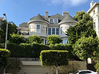
The Chambers Mansion is a historic house that was built in 1887, and is located at 2220 Sacramento Street in the Pacific Heights neighborhood of San Francisco, California. In 2010, CBS News declared the Chambers Mansion one of the "scariest haunted houses" in the United States, based on stories of its dark history.