Queens Quay (Toronto)

Last updated

Queens Quay

Queens Quay at Ann Tindal Park.jpg
Looking east down Queens Quay, next to Ann Tindal Park.
Major junctions
West endStadium Road
East endParliament St
Location
Country Canada
Province Ontario
Major cities Toronto
Highway system
  • Roads in Toronto
Nearby arterial roads
  Lake Ontario Queens Quay Lake Shore Boulevard  

Queens Quay is a prominent street in the Harbourfront neighbourhood of Toronto, Ontario, Canada. [1] The street was originally commercial in nature due to the many working piers along the waterfront; parts of it have been extensively rebuilt in since the 1970s with parks, condominiums, retail, as well as institutional and cultural development.

Contents

History

The road supplanted both Front Street and Lake Shore Boulevard as the most southerly east–west corridor in the city when it was created on reclaimed land in the inner harbour. Sometime after 1919 to the early 1920s the inner harbour was filled in and new slips were created.

Queens Quay in 1910 Queen's Quay in 1910.jpg
Queens Quay in 1910

Queens Quay continues to go through a significant transformation. Originally, it served as an access road for the various ports and slips in the inner harbour. The street between Yonge Street and Parliament Street was home to storage buildings devoted to trade on the Saint Lawrence Seaway, major industries such as the Redpath Sugar Refinery and Victory Mills, as well as small commercial enterprises. [2] However, the mainly industrial uses along Queens Quay were slowly replaced by commercial and residential uses, mainly high-rise condominiums. Between 1975 and 1979, a cluster of large, concrete towers were erected at the foot of Bay Street, south of Queens Quay; these included the Westin Harbour Castle and Harbour Square. In 1990, the 40-storey York Quay towers were built and remain the tallest buildings on Queens Quay. [3] The scale and density of these and subsequent high-rise development along Queens Quay were criticized for blocking the lake and failing to provide a welcoming realm for visitors. In 1997 City School (Toronto) relocated to 635 Queens Quay West. [4] In 1999, the Toronto Transit Commission opened a dedicated streetcar right-of-way in the median from Bay Street to Bathurst Street.

In 2001, the city planners set out to improve Queens Quay by reclaiming public space for pedestrians and cyclists. This resulted in the Waterfront Toronto Central Waterfront Public Realm International Design Competition, which was completed in 2006. In August 2006, the city closed the two eastbound lanes, replacing them with bike lanes as part of the Martin Goodman Trail and additional pedestrian space. The experiment resulted in an improved public realm and more visitors to the overall waterfront area. [5]

In 2009, Waterfront Toronto announced its plans to turn Queens Quay into a grand lakefront boulevard by placing streetcar lanes in the centre, traffic only on the north side and a pedestrian-focused space on the south side. [6] The plan would restrict Queen's Quay to two traffic lanes, on the north side of the streetcar tracks, similar to the design of the 2006 experiment. Additionally, the plan calls for the beautification and extension of the Harbourfront streetcar line along Queen's Quay East between Yonge and Cherry Street. The transit right-of-way will be grass-covered. [7] [8]

In 2013 Ontario Square and Canada Square opened. The former is an open public space and the latter a green area. Both replace the former parking lot, which is now underground. [9]

Transportation

Queens Quay is served by two streetcar lines, operating on a dedicated right-of-way. The 509 Harbourfront and 510 Spadina both terminate at Union Station and run along Queens Quay from Bay Street, westward. At Spadina Avenue, the 510 heads north to Spadina station, and the 509 continues west, bound for the Exhibition Loop. [10] [11]

Originally there was to have been an underground station in front of the Westin Harbour Castle Hotel and the Jack Layton Ferry Terminal, [12] with underground access to the hotel. This plan was cancelled when the hotel management became unwilling to share in the cost, and a smaller station was built around the corner under Bay Street.

Plans to add a Queens Quay East light rail line are the subject of a class environmental assessment. [13] Various bus routes currently serve portions of the eastern portion of Queens Quay: the 19 Bay operates from Bay Street to Sherbourne Street; the 65 Parliament and the 365 Parliament Blue Night operate from Sherbourne Street to Parliament Street; the 72 Pape and the 202 Cherry Beach operate from Bay Street to Parliament Street; the 75 Sherbourne operates from Jarvis Street to Sherbourne Street; and the 320 Yonge Blue Night buses operates from Bay Street to Yonge Street.

Landmarks

LandmarkCross streetNotesImage
Little Norway Park Bathurst Little Norway Park.jpg
Canada Malting Silos BathurstAbandoned storage silos since 1980s; germination and kiln buildings demolished 2010 Canada Malting Silos.JPG
Toronto Music GardenSpadina Toronto - ON - Toronto Music Garden.jpg
Walter Carsen Centre Spadinaheadquarters of the National Ballet of Canada Walter Carson Centre.JPG
Empire Sandy Spadina Empire Sandy.jpg
HTO Park Spadina Hto Park Urban Beach 2.jpg
Toronto Waterfront WaveDecks Spadina, Rees, Lower Simcoe SimcoeWavedeck2.jpg
Harbourfront Centre Lower Simcoea cultural centre built by the federal government as part of the Harbourfront Park development Harbourfront-Centre.jpg
Queen's Quay Terminal YorkBuilt in 1926 as a cold storage warehouse facility turned into condos in the 1980s TorontoWaterFront10.jpg
Queens Quay station BayUnderground LRT station QueensQuayTTC6.jpg
Westin Harbour Castle Hotel BayBuilt in 1975 as Harbour Castle Hilton and became a Westin hotel in 1987 WestinHarbourCastleHotel.jpg
World Trade Centre Yonge WTC Toronto.JPG
Captain John's Harbour Boat Restaurant (1975-2015)YongeRestaurant on a permanently docked boat (Restaurant closed 2011 and ship was removed from dock on May 28, 2015 for recycling in Port Colborne, Ontario) CaptainJohnsSeafood2.jpg
One Yonge Street YongeToronto Star headquarters One Yonge Street.jpg
Redpath Sugar Refinery JarvisLast active industrial site along the quay RedpathSugarRefinery.jpg
The Guvernment JarvisNight club opened in 1980s and closed 2015; demolition began in 2015 as property sold to condo developer Daniels Corporation The Guvernment.jpg
Sugar Beach Jarvis SugarBeach P1050763.JPG
Corus Quay JarvisHome of Corus Entertainment and first major development in the East Bayfront District Corus Quay under construction.JPG
Victory Soya Mills Silos (Central Soya Mills)ParliamentBuilt 1943 and abandoned industrial silos since 1991; designated historic site Victory Silos.JPG

Quays and slips along Queens Quay

Listed from west to east

Related Research Articles

<span class="mw-page-title-main">Harbourfront, Toronto</span> Neighbourhood in Toronto, Ontario, Canada

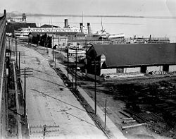
Harbourfront is a neighbourhood on the northern shore of Lake Ontario within the downtown core of the city of Toronto, Ontario, Canada. Part of the Toronto waterfront, Harbourfront extends from Bathurst Street in the west, along Queens Quay, with its ill-defined eastern boundary being either Yonge Street or York Street. Its northern boundary is the Gardiner Expressway. Much of the district was former water lots filled in during the early 1900s to create a larger harbour district. After shipping patterns changed and the use of the Toronto harbour declined, the area was converted from industrial uses to a mixed-use district that is mostly residential and leisure.

<span class="mw-page-title-main">Toronto waterfront</span> Shore of Lake Ontario in Toronto, Canada

The Toronto waterfront is the lakeshore of Lake Ontario in the city of Toronto, Ontario, Canada. It spans 46 kilometres between the mouth of Etobicoke Creek in the west and the Rouge River in the east.

<span class="mw-page-title-main">Toronto Harbour</span> Bay on the north shore of Lake Ontario, in Toronto, Ontario, Canada

Toronto Harbour or Toronto Bay is a bay on the north shore of Lake Ontario, in Toronto, Ontario, Canada. It is a natural harbour, protected from Lake Ontario waves by the Toronto Islands. Today, the harbour is used primarily for recreational boating, including personal vessels and pleasure boats providing scenic or party cruises. Ferries travel from docks on the mainland to the Islands, and cargo ships deliver aggregates and raw sugar to industries located in the harbour. Historically, the harbour has been used for military vessels, passenger traffic and cargo traffic. Waterfront uses include residential, recreational, cultural, commercial and industrial sites.

<span class="mw-page-title-main">Spadina station</span> Toronto subway station

Spadina is a subway station on Line 1 Yonge–University and Line 2 Bloor–Danforth in Toronto, Ontario, Canada. It is located on Spadina Road, north of Bloor Street West. It is one of only two stations open overnight, along with Union station. Wi-Fi service is available at this station.

<span class="mw-page-title-main">Union station (TTC)</span> Toronto subway station

Union is a subway station on Line 1 Yonge–University of the Toronto subway in Toronto, Ontario, Canada. It opened in 1954 as one of twelve original stations on the first phase of the Yonge line, the first rapid transit line in Canada. It was the southern terminus of the line until the opening of the University line in 1963, and is today the inflection point of the U-shaped line. Along with Spadina station, it is one of two stations open overnight to support late-night streetcar routes.

<span class="mw-page-title-main">Queen station</span> Toronto subway station

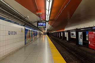
Queen is a subway station on Line 1 Yonge–University in Toronto, Ontario, Canada. It is located under Yonge Street north from Queen Street to Shuter Street. Wi-Fi service is available at this station.

<span class="mw-page-title-main">Lake Shore Boulevard</span> Street in Toronto

Lake Shore Boulevard is a major arterial road running along more than half of the Lake Ontario waterfront in the city of Toronto, Ontario, Canada. Prior to 1998, two segments of Lake Shore Boulevard were designated as part of Highway 2, with the highway following the Gardiner Expressway between these two sections.

The Queen Street subway line was a proposed subway line for the city of Toronto, Ontario, Canada. It was one of many subway lines planned for, but has yet to be built by the Toronto Transit Commission.

<span class="mw-page-title-main">Toronto streetcar system</span> Streetcar network in Ontario, Canada

The Toronto streetcar system is a network of ten streetcar routes in Toronto, Ontario, Canada, operated by the Toronto Transit Commission (TTC). It is the third busiest light-rail system in North America. The network is concentrated primarily in Downtown Toronto and in proximity to the city's waterfront. Much of the streetcar route network dates from the 19th century. Most of Toronto's streetcar routes operate on street trackage shared with vehicular traffic, and streetcars stop on demand at frequent stops like buses. Since 2019, the network has used low-floor streetcars, making it fully accessible.

<span class="mw-page-title-main">510 Spadina</span> Streetcar route in Toronto, Canada

510 Spadina is a Toronto streetcar route in Ontario, Canada, operated by the Toronto Transit Commission.

<span class="mw-page-title-main">509 Harbourfront</span> Streetcar route in Toronto, Canada

509 Harbourfront is a Toronto streetcar route in Ontario, Canada, operated by the Toronto Transit Commission and connecting Union Station with Exhibition Loop.

<span class="mw-page-title-main">512 St. Clair</span> Streetcar route in Toronto, Canada

The 512 St. Clair is an east–west streetcar route in Toronto, Ontario, Canada, operated by the Toronto Transit Commission (TTC). It operates on St. Clair Avenue between St. Clair station on the Line 1 Yonge–University subway and Gunns Road, just west of Keele Street.

<span class="mw-page-title-main">Queens Quay station</span> Streetcar station in Toronto, Canada

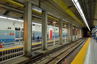
Queens Quay is an underground streetcar station of the Toronto streetcar system in Toronto, Ontario, Canada. It is the only underground streetcar station that is not part of or connected to a Toronto subway station. It was opened in 1990 as part of the former Harbourfront LRT route. The station is now served by the 509 Harbourfront, 510 Spadina daytime routes and the 310 Spadina night route.

<span class="mw-page-title-main">WaveDecks</span>

The Toronto Waterfront Wavedecks are a series of wooden structures constructed on the waterfront of Toronto, Ontario, Canada, as part of the revitalization of the central waterfront. Waterfront Toronto committed to constructing a series of unique wooden wavedecks along the water's edge for the 3.5 km area running from Bathurst Street to Parliament Street. All the WaveDecks are accessible from the southside of Queens Quay.

<span class="mw-page-title-main">Toronto streetcar system loops</span>

Turning loops of the Toronto streetcar system serve as termini and turnback points for streetcar routes in Toronto, Ontario, Canada. The single-ended streetcars require track loops in order to reverse direction. Besides short off-street track loops these can also be larger interchange points, having shelters and driver facilities, or be part of a subway station structure for convenient passenger interchange.

<span class="mw-page-title-main">East Bayfront</span> Neighbourhood in Toronto, Ontario, Canada

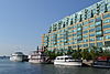
East Bayfront, or the East Bayfront Precinct, is an emerging neighbourhood in Toronto, Ontario, Canada. It is currently undergoing a transformation from industrial use to mixed-use as part of Waterfront Toronto's plans to create a residential and commercial district urban core near the lake.

East Bayfront LRT, also known as the Waterfront East LRT, is a planned Toronto streetcar line that would serve the East Bayfront and Port Lands areas in Toronto, Ontario, Canada. It would run from Union station under Bay Street and along Queens Quay and Cherry Street to a new Villiers Loop along Commissioners Street east of Cherry Street on Villiers Island. It would complement the existing 509 Harbourfront service that connects Union Station to Queens Quay west of Bay Street. Longer-term plans are to extend the East Bayfront line from Cherry and Commissioners Streets to the planned East Harbour Transit Hub along GO Transit's Lakeshore East line and the planned Ontario Line.

<span class="mw-page-title-main">Spadina streetcar line (1923–1948)</span> Former streetcar route in Toronto, Ontario

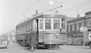
The Toronto Transit Commission operated a separate Spadina streetcar line on Spadina Avenue, from 1923 to 1948. Spadina Avenue is a major north–south road in downtown Toronto.

<span class="mw-page-title-main">Toronto Railway Company Belt Line</span>

The Toronto Railway Company Belt Line was a streetcar route that operated in Toronto, Ontario, Canada. The route was created by the Toronto Railway Company in 1891 and taken over by the Toronto Transportation Commission in 1921, which cancelled the route in 1923 as part of its reorganization of streetcar routes.

<span class="mw-page-title-main">Harbour Square Park</span> Park in Toronto, Canada

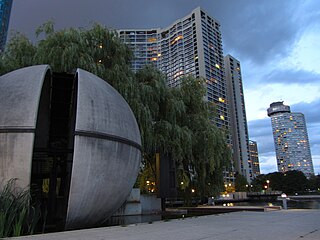
Harbour Square Park is a park in Toronto, Ontario, Canada right on the Toronto harbour. It is next to the Harbour Square condos, the Jack Layton Ferry Terminal and the Westin Harbour Castle. It is south of Queens Quay and adjacent to the Queens Quay streetcar station. It contains a boardwalk and a permanent public art installation.

References

  1. Jack Lakey (2014-01-23). "Streetcar rails test patience of Queens Quay pedestrians: The Fixer". Toronto Star. Archived from the original on 2014-01-24. Those who know it only as the location of the island ferry docks or Sugar Beach might be surprised to learn that it was lined with warehouses until someone figured out it was some of Toronto's best real estate.
  2. Filey, Mike (13 March 2010). "History on the waterfront". Toronto Sun . Retrieved 8 February 2011.
  3. Development
  4. "Archived copy" (PDF). Archived from the original (PDF) on 2017-09-07. Retrieved 2017-09-07.{{cite web}}: CS1 maint: archived copy as title (link)
  5. Experiment Archived August 30, 2006, at the Wayback Machine
  6. "City Council approves plan to transform Queens Quay." Canada NewsWire. Oct 1, 2009.
  7. Master Plan Archived May 11, 2013, at the Wayback Machine
  8. John Spears (September 11, 2009). "Slow start for a new Queens Quay". The Star. Toronto. Retrieved February 7, 2011.
  9. "New on Toronto's waterfront: Ontario Square, Canada Square". The Star. Toronto. 21 June 2013.
  10. James Bow. "Route 509 - The New Harbourfront Streetcar Archived March 4, 2016, at the Wayback Machine ." Transit Toronto. July 26, 2009
  11. James Bow. "Route 510 - The Spadina Streetcar Archived January 13, 2005, at the Wayback Machine ." Transit Toronto. November 10, 2006
  12. Peter Howell (1990-03-12). "TTC fighting on two fronts Province, Toronto give it rough ride". Toronto Star. p. A.15. Retrieved 2012-03-13. The constant bickering between the TTC and Toronto over serving the ferry dock led to the recent decision by the owners of the Harbour Castle Westin to withdraw their $2.5 million share of the $4 million cost. The TTC now plans to build a smaller stop on the north side of Queens Quay, which means thousands of people will have to cross the busy street to take the ferries.
  13. www.ene.gov.on.ca Archived January 28, 2007, at the Wayback Machine

Commons-logo.svg Media related to Queens Quay, Toronto at Wikimedia Commons