Questa is a village in Taos County, New Mexico, United States. The population was 1,770 at the 2010 census. The village has trails into the Rio Grande Gorge, trout fishing, and mountain lakes with trails that access the Sangre de Cristo Mountains that overlook the area.[citation needed] Questa is on the Enchanted Circle Scenic Byway, near the confluence of the Rio Grande and the Red River. The "Gateway to the Rio Grande del Norte Monument", its visitors can drive to an overlook of the Red River meeting the Rio Grande in the depth of the gorge. The Carson National Forest parallels Questa to the east. The Columbine Hondo Wilderness and Latir Peak Wildness are in the Carson National Forest close to Questa.
With a large Hispanic population, the village economy was historically largely dependent on agriculture and income from a now-closed Chevronmolybdenum mine. Many residents also commute to Taos, Red River, and Angel Fire to work in the hospitality industries there.
According to the United States Census Bureau, the village has a total area of 5.1 square miles (13km2), all land. The village is a regional hub for the smaller outlying communities of Lama, Cerro, Sunshine Valley, Latir, Costilla, and Amalia. Questa is surrounded by the Rio Grande del Norte National Monument to the west and the Carson National Forest to the East.
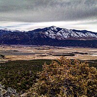
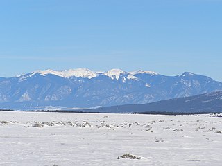
Questa lies at the western base of the Taos Mountains, part of the Sangre de Cristo Mountains. Rising above the town to the northeast is the Latir Peakmassif, headed by Venado Peak, 12,734ft (3,881m); Pinabete Peak, a southwestern outlier of the group, rises closest to Questa. To the southeast lies Flag Mountain, a northwestern spur of the group of mountains that includes Wheeler Peak, the highest peak in New Mexico. To the north and west lie the Rio Grande Gorge, cutting a volcanic plateau dotted with several peaks of volcanic origin in the Rio Grande del Norte National Monument.
History
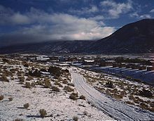
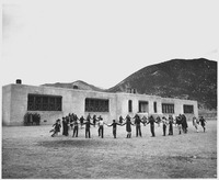
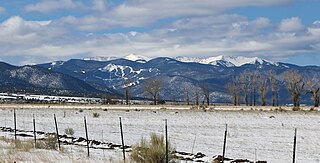
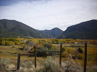
Overview of the Village of Questa looking from west to east from the Rio Grande del Norte National Monument Las Vistas de Questa TrailSchool at Questa in 1941
Questa was originally named San Antonio del Rio Colorado. In 1883, a U.S. postmaster changed its name to Questa.[4] The postmaster misspelled the name, as it should have been spelled "Cuesta," which is Spanish for "ridge" or "slope." Despite the error, the village has kept the name.[5]
The Oshara tradition dated to about 3000 BCE is the first known archaelogical evidence of Native American (Indians) residence near Questa. The Oshara were possibly the ancestors of the present day Pueblo peoples. A later trade route, called the "Kiowa Trail" or the Taos Mountain Trail, ran through Questa and connected the agricultural Pueblo peoples in New Mexico to the bison-hunting Plains Indians on the Great Plains of Colorado..[6] The first Spaniards to visit the area were members of the Coronado expedition who visited Taos Pueblo, 20mi (32km) south of Questa, in 1540.
The Spanish settlement of Don Fernando de Taos adjacent to Taos Pueblo was founded about 1615.[7] Thereafter, Spanish expeditions and hunters and miners probably visited the Questa area although the first documented visit by the Spanish was not until July 1694. In that year, Governor Diego de Vargas led an expedition northward from Santa Fe in search of food for the destitute Spanish colony. Vargas confiscated grain from several Pueblo villages, but on arriving in Taos, decided to return to Santa Fe via a roundabout route northward to avoid conflict with the Puebloans. Vargas and his expedition of 100 men passed by the future site of Questa along the "Rio Colorado" (Red River of New Mexico). He noted that the area was inhabited by the "Apaches de Acho". Utes, who were hostile to the Spanish, also lived nearby. Bison were plentiful in the region.[8] The hostility of the Ute and Apache -- and later the Comanche -- prevented Spanish expansion northward from Taos to Questa.[9]
The site of Questa was first called Rio Colorado. Concerned about encroachments by French and American fur trappers and traders, the Spaniards established a short-lived military post at the Rio Colorado in about 1815. In the same year a land grant from the Governor of New Mexico granted 50 families permission to establish a settlement at Rio Colorado. In 1817, the military in Rio Colorado refused entry into New Mexico and arrested French/American traders Auguste Pierre Chouteau and Jules de Mun and confiscated their goods. By 1822, the settlement was abandoned "for feer of the Indeans now at War With them." [10]
Mexican independence from Spain 1821 resulted in a more tolerant attitude toward Americans by the New Mexican government. By 1829, Rio Colorado had been resettled, mostly by Hispanics but also by a few French/Americans. The New Mexican government encouraged settlement on its frontiers by land grants to Mexican citizens (which included many of Anglo and French descent). Large grants of land were made to prospective settlers in 1836 and 1841 and the town of San Antonio del Rio Colorado was legally established in 1842.
New Mexico became part of the United States after the Mexican-American War from 1846 to 1848. Indian raids in the area continued until the 1860s. The location of the village astride ancient trade, raiding, and hunting routes, made resource-based conflict between cultures inevitable. Additionally, the village location blocked access to certain historic clay and pigment quarries of ceremonial importance to the Taos tribe. This continued conflict led to the village being repeatedly abandoned. Spanish, Mexican, and eventually American soldiers detailed to defend the beleaguered settlement frequently expressed great frustration with their posting.[11]
The names of two prominent peaks overlooking the village of Questa, Flag Mountain and Sentinel Peak, refer to the practice during this period of stationing watchmen on these high points to warn the village of approaching war parties.
The village, nearly from the beginning, was of mixed blood; the surnames Lafore or Laforet, Ledoux, and LaCome reflect the names of French or French-Canadian trappers who settled in the area after arriving in search of otter and beaver. New Mexico territory license records list Auguste Lacome as residing in the area as a trader with the surrounding Native Americans. The common surname Rael may also reflect the influence of Jewish immigrants arriving after being expelled from Spain. The village had a reputation for being contentious and requiring disproportionate effort to police; records show that viceregal intervention was frequently required to settle property disputes.[11]
Arts and culture
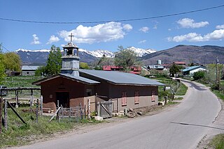
Historic San Antonio del Rio Colorado Church of Questa
The Historic San Antonio del Rio Colorado Church is in the historic plaza of Questa, present since the mid-1800s. After a collapse of the west wall in Questa's historic church, the community is restoring it. Made with adobe and woodwork, it was scheduled to be completed mid-2016.
Questa has Ocho, an art gallery and event space.
Event series
Questa has a summer event series that celebrates art, youth, and the environment in special sub-themed events, including Mud Bogg, the Questa Fiesta, and Alumbra de Questa.
Parks and recreation
Questa has two local parks: the Municipal Park and the Moly Park. The Moly Park contains public athletic fields.
Eagle Rock Lake Questa, NM
Surrounding Questa are the Rio Grande del Norte National Monument and the Carson National Forest. Outside Questa's Village limits is Eagle Rock Lake. The Red River is currently[when?] undergoing restoration to improve trout habitat, with the section parallel to Eagle Rock Lake complete.[citation needed] Cabresto Lake features hiking trails to mountaintop lakes in the Latir Peaks Wilderness. In the Rio Grande del Norte National Monument are two popular locations: the La Junta Overlook, where the Rio Grande and the Red River come together over 800 feet below, and the Big Arsenic Trail containing petroglyphs and a natural spring.
As of the census[13] of 2000, there were 1,767 people, 741 households, and 512 families residing in the village. The population density was 365.0 inhabitants per square mile (140.9/km2). There were 888 housing units at an average density of 173.9 per square mile (67.1/km2). The racial makeup of the village was 50.16% White, 0.11% African American, 0.70% Native American, 0.05% Asian, 0.11% Pacific Islander, 43.40% from other races, and 5.47% from two or more races. Hispanic or Latino of any race were 80.53% of the population.
There were 741 households, out of which 35.6% had children under the age of 18 living with them, 49.3% were married couples living together, 13.8% had a female householder with no husband present, and 30.8% were non-families. 26.5% of all households were made up of individuals, and 9.9% had someone living alone who was 65 years of age or older. The average household size was 2.52 and the average family size was 3.02.
In the village, the population was spread out, with 28.0% under the age of 18, 7.4% from 18 to 24, 26.3% from 25 to 44, 25.4% from 45 to 64, and 12.9% who were 65 years of age or older. The median age was 38 years. For every 100 females, there were 95.4 males. For every 100 females age 18 and over, there were 95.3 males.
The median income for a household in the village was $23,448, and the median income for a family was $30,000. Males had a median income of $26,667 versus $20,000 for females. The per capita income for the village was $13,303. About 20.7% of families and 24.3% of the population were below the poverty line, including 29.8% of those under age 18 and 20.4% of those age 65 or over.
Economy
The Rio Grande in the Rio Grande del Norte National Monument
The Chevron Questa molybdenum mine, nine miles (14km) from Questa, was the largest private employer in Taos County.[14] The mine opened in 1916 as the R&S Molybdenum mine. It was purchased by Molycorp Minerals in 1950 and became a subsidiary of Chevron in 2005.[15] Formerly an open pit excavation, the Chevron Questa mine operated as an underground mine from 1982.[16] Economic conditions that affect the mine resulted in a 54 percent cut in personnel in February 2009, which primarily impacted the residents of Questa.[14] On June 2, 2014, Chevron Mining announced the immediate and permanent closure of the mine due to continuing low molybdenum prices and high operating costs.[17] The mine was employing about 300 people at the time of the shutdown. The mine employs about 150 people on work related to reclamation and remediation, either directly or through its contractors.
Agriculture, especially the cultivation of alfalfa, hay, and winter wheat, has experienced renewed interest along with the expansion of agriculture to historic crops and crops of high value. Agriculture in Questa is strongly dependent on irrigation, supplied from the Red River and Cabresto Creek. The system of ditches or acequias that supplies water to the fields is of great community and social importance; the burning of the ditches on the first weekend after the vernal equinox is a major community event. Two major 'ditch associations' control the distribution of water by controlling the outflow from the Cabresto Lake dam: the Acequia Madre and the Llano ditch.
Historically, sheep were raised in and around Questa, but they have been replaced by cattle. Cattle are grazed on the plains north and west of town during the winter and spring, then moved west to the other side of the Rio Grande in early June, usually driven across the "Sheep Crossing" ford by riders on horseback.
Increasingly, the traditional economy based on agriculture, livestock, handicrafts (particularly wooden religious carvings known as santos), wood gathering, and honey is failing to meet the financial needs of the populace of Questa. Some locals blame the rising cost on the influx of celebrities and affluent Anglos to the Taos area driving up land and home prices, but for whatever cause an increasing number of Questeños commute to work in Red River, Taos, and Angel Fire.[citation needed]
Questa has developed as a tourist destination. With the Historic San Antonio del Rio Colorado Church, Rio Grande del Norte National Monument, Eagle Rock Lake, and the Carson National Forest several avenues for tourism based economic opportunities have taken shape and continue to grow based on the previous and to be expanded tourist activities.
Education
Questa Independent School System is the local school district.[18] It operates two schools: Alta Vista Elementary & Intermediate School, and Questa Junior & Senior High School.
Roots and Wings Community school, an Expeditionary Learning School, is near Questa in the Lama area.[19]
Government
Questa is a municipal government founded in 1842. The Village of Questa is governed by a mayor, currently John Ortega, and a four-member Village Council who have 4-year staggered terms.
Infrastructure and transportation
Major highways
Road in the Rio Grande del Norte National Monument
Questa's village center has the two major New Mexico State Highways: 522 and 38. State Highway 522 heads south to Taos and north to the Colorado border. State Highway 38 connects Questa to Red River and Eagle Nest as part of the Enchanted Circle.
Transportation
Questa is serviced by the North Central RTD's Blue Bus service which provides free service to Red River and Taos during commuting hours. For air travel the Questa Municipal Airport Nr 2, owned by the Village of Questa, is available.
Utilities
The Water/Sewer Department of the Village of Questa operates water and sewer for the Questa Area. Kit Carson Electric Cooperative, Inc. supplies electricity and is in the process of implementing a fiber optic project in Taos County.
Healthcare
Presbyterian Medical Services' Questa Health Clinic provides medical, dental, and behavioral health care for Questa and the surrounding area. The Holy Cross Hospital in Taos is the nearest hospital to Questa at roughly 30 miles (48km) from the Village.
Taos is a town in Taos County in the north-central region of New Mexico in the Sangre de Cristo Mountains. Initially founded in 1615, it was intermittently occupied until its formal establishment in 1795 by Nuevo México Governor Fernando Chacón to act as fortified plaza and trading outpost for the neighboring Native American Taos Pueblo and Hispano communities, including Ranchos de Taos, Cañon, Taos Canyon, Ranchitos, El Prado, and Arroyo Seco. The town was incorporated in 1934. As of the 2010 census, its population was 5,716.
Taos County is a county in the U.S. state of New Mexico. As of the 2020 census, the population was 34,489. Its county seat is Taos. The county was formed in 1852 as one of the original nine counties in New Mexico Territory.
Rio Grande County is a county located in the U.S. state of Colorado. As of the 2020 census, the population was 11,539. The county seat is Del Norte. The county is named for the Rio Grande, which flows through the county.
Del Norte is a Statutory Town that is the county seat of Rio Grande County, Colorado, United States. The town's name is most commonly pronounced /ˈdɛl nɔɹt/. The town population was 1,458 at the 2020 United States Census.
Jornada del Muerto was the name given by the Spanish conquistadors to the Jornada del Muerto desert basin, and the almost waterless 90-mile (140 km) trail across the Jornada beginning north of Las Cruces and ending south of Socorro, New Mexico. The name translates from Spanish as "Dead Man's Journey" or "Route of the Dead Man". The trail was part of the Camino Real de Tierra Adentro which led northward from central colonial New Spain, present-day Mexico, to the farthest reaches of the viceroyalty in northern Nuevo México Province.
The Sangre de Cristo Mountains are the southernmost subrange of the Rocky Mountains. They are located in southern Colorado and northern New Mexico in the United States. The mountains run from Poncha Pass in South-Central Colorado, trending southeast and south, ending at Glorieta Pass, southeast of Santa Fe, New Mexico. The mountains contain a number of fourteen thousand foot peaks in the Colorado portion, as well as several peaks in New Mexico which are over thirteen thousand feet.
Carson National Forest is a national forest in northern New Mexico, United States. It encompasses 6,070 square kilometers and is administered by the United States Forest Service. The Forest Service's "mixed use" policy allows for its use for recreation, grazing, and resource extraction.
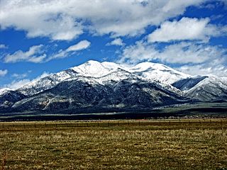
Venado Peak is one of the major peaks of the Taos Mountains group of the Sangre de Cristo Mountains, a subrange of the Rocky Mountains. It is located in Taos County, New Mexico, about 8 miles (13 km) northeast of the town of Questa. Its summit is the highest point in the Latir Peak Wilderness, part of Carson National Forest. The peak's name means "deer" in Spanish.
Latir Peak Wilderness is a 20,506-acre (8,298 ha) wilderness area located within the Carson National Forest in northern New Mexico. Designated in 1980, the wilderness is composed of dense forest, meadows, and alpine tundra on Latir Mesa in the northern portion. It includes a portion of the Sangre de Cristo Mountains and contains Venado Peak at 12,734 feet (3,881 m), Latir Peak at 12,708 feet (3,873 m), Latir Mesa at 12,692 feet (3,869 m), and Virsylvia Peak at 12,594 feet (3,839 m). Most of the area is drained by the Lake Fork of Cabresto Creek, which originates at Heart Lake and is impounded just outside the wilderness in Cabresto Lake, the main trailhead for visitors entering the wilderness.
The following is an alphabetical list of articles related to the U.S. state of New Mexico.
The 56-mile (90 km) High Road to Taos is a scenic, winding road through the Sangre de Cristo Mountains between Santa Fe and Taos.. It winds through high desert, mountains, forests, small farms, and tiny Spanish land grant villages and Pueblo Indian villages. Scattered along the way are the galleries and studios of traditional artisans and artists drawn by the natural beauty. It has been recognized by the state of New Mexico as an official scenic byway.
Northern Rio Grande National Heritage Area is a federally designated National Heritage Area in the U.S. state of New Mexico. The national heritage area includes a section of the upper Rio Grande Valley that has been inhabited by the Puebloan peoples since the early Pre-Columbian era.
The Rio Grande del Norte National Monument is an approximately 242,555-acre (98,159 ha) area of public lands in Taos County, New Mexico, United States, proclaimed as a national monument on March 25, 2013, by President Barack Obama under the provisions of the Antiquities Act. It consists of the Rio Grande Gorge and surrounding lands, managed by the Bureau of Land Management (BLM).
San Antonio Mountain is a free-standing volcanic peak in Rio Arriba County, New Mexico. With an elevation of 10,908 feet, San Antonio Mountain is the highest peak within the Taos Plateau volcanic field, the largest volcanic field within the Rio Grande Rift valley.
The Enchanted Circle Scenic Byway is a New Mexico Scenic Byway and National Forest Scenic Byway located in Northern New Mexico. It begins and ends in Taos, New Mexico.
Wild Rivers Recreation Area is located in north central New Mexico within the Rio Grande del Norte National Monument. Two rivers that run through the park, the Rio Grande and Red River are National Wild and Scenic Rivers. NM 378 that traverses the recreation area is designated a New Mexico Scenic Byway. Recreational opportunities include whitewater rafting, hiking, biking, fishing and camping.
Rio San Antonio is a tributary of the Conejos River in northern New Mexico and southern Colorado. Via the Conejos River, it is part of the upper Rio Grande system. The river is used extensively for irrigation in its lower course through the southern San Luis Valley.
The Tusas Mountains are a mountain range in northern New Mexico, extending slightly into southern Colorado. They are considered the southeasternmost part of the San Juan Mountains. Grouse Mesa, 11,407 feet (3,477 m), is the highest peak in the range. The mountains are located to the west of Taos and northwest of Santa Fe. The Tusas Mountains are a wide region of upland mesas and gently sloping mountains, dissected in places by deep canyons.
The Amalia Tuff is a geologic formation exposed in and around Questa, New Mexico. It has a radiometric age of 25.39 ± 0.04 million years, corresponding to the Oligocene epoch.
The Latir volcanic field is a large volcanic field near Questa, New Mexico, that was active during the late Oligocene to early Miocene, 28 to 22 million years ago (Ma). It includes the Questa caldera, in whose deeply eroded interior is located the Molycorp Questa molybdenum mine.
Schilling, John, 1990. A history of the Questa molybdenum (moly) mines, Taos County, New Mexico. New Mexico Geological Society Guidebook, 41st Annual Field Conference, Southern Sangre de Cristo Mountains, New Mexico, p. 381-386.
This page is based on this Wikipedia article Text is available under the CC BY-SA 4.0 license; additional terms may apply. Images, videos and audio are available under their respective licenses.