 | ||||
|---|---|---|---|---|
| Route information | ||||
| Length | 114 km (71 mi) | |||
| Major junctions | ||||
| North end | ||||
| South end | ||||
| Location | ||||
| Country | South Africa | |||
| Highway system | ||||
| ||||
The R500 is a Regional Route in South Africa that connects Magaliesburg with Parys via Carletonville and Fochville. [1]
| | ||||
|---|---|---|---|---|
| Route information | ||||
| Length | 114 km (71 mi) | |||
| Major junctions | ||||
| North end | ||||
| South end | ||||
| Location | ||||
| Country | South Africa | |||
| Highway system | ||||
| ||||
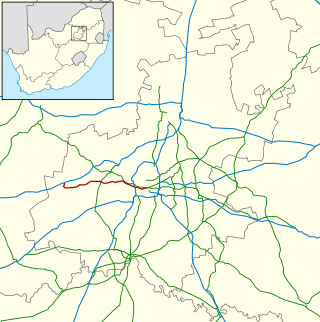
The R500 is a Regional Route in South Africa that connects Magaliesburg with Parys via Carletonville and Fochville. [1]
The R500 begins in the North West, 10 kilometres west of Magaliesburg, at a junction with the R509, going southwards. After 2 kilometres, it crosses into Gauteng province.
From the R509 junction, it goes southwards for 21 kilometres to reach a junction with the N14 national route. It proceeds southwards for a further 3 kilometres to meet the western end of the R41 route from Randfontein.
From the R41 junction, the R500 continues southwards for 16 kilometres, bypassing Khutsong and the Abe Bailey Nature Reserve, to enter the towns of Oberholzer and Carletonville. It enters as Ada Street and becomes Station Street eastwards for a few metres (where it meets the R559 route) before becoming Annan Road southwards. It heads south through Carletonville Central to reach a junction with the R501 road.
Continuing south, it heads south-south-east for 12 kilometres to reach a junction with the N12 national route and then bypasses Fochville to the east. From Fochville, the R500 heads southwards to intersect with the R54 road from Potchefstroom in the west and Vereeniging in the east.
Just after the R54 junction, the R500 crosses back into the North West province and proceeds southwards for 30 kilometres to reach a junction with the R53 road. The R53 and R500 become co-signed southwards for 2.5 kilometres, crossing the Vaal River into the Free State province, to reach their southern terminus at a junction with the R59 road in the town of Parys (west of the town centre).

The R24 is a major East-West provincial route in the Gauteng and North West provinces that links OR Tambo International Airport with Rustenburg via Johannesburg, Krugersdorp and Magaliesburg. The process of renaming the streets and freeway that form the route from Krugersdorp eastward to OR Tambo International after anti-apartheid stalwart Albertina Sisulu was completed in 2013.

The R28 is a provincial route in Gauteng, South Africa that connects Krugersdorp with Vereeniging via Randfontein. The R28 used to connect with Pretoria, but that section of the road is now part of the N14.

The R30 is a provincial route in South Africa that connects Bloemfontein with Rustenburg via Brandfort, Welkom, Bothaville, Klerksdorp and Ventersdorp. The southern part of the route is tolled, as the R30 forms the first section of the ZR Mahabane Toll Route, with the Brandfort Toll Plaza found 10 kilometres north of its Southern junction with the N1 National Route. The tolled portion ends at the junction with the R730.

The R33 is a provincial route in South Africa that connects Pietermaritzburg with Lephalale via Greytown, Paulpietersburg, Carolina, Belfast and Vaalwater. It is a very long road, passing through 3 provinces.

The R36 is a provincial route in South Africa that connects the N1 with Ermelo, via Tzaneen and Lydenburg. It is co-signed with the N4 for 8 kilometres between Machadodorp and Patattanek, with a tollgate on this section. It used to extend further south past Ermelo to Amersfoort, but that section is now designated as part of the N11.

The R37 is a provincial route in South Africa that connects Polokwane with Nelspruit (Mbombela) via Burgersfort and Lydenburg.
The R41 is a provincial route in Gauteng, South Africa, that connects Johannesburg with Randfontein via Roodepoort.

The R42 is a provincial route in South Africa that connects Vanderbijlpark with Bronkhorstspruit via Vereeniging, Heidelberg, Nigel and Delmas.

The R53 is a provincial route in South Africa that connects Swartruggens with Parys via Ventersdorp and Potchefstroom.

The R54 is a provincial route in South Africa that connects Potchefstroom with Villiers via Vereeniging.

The R57 is a provincial route in South Africa that connects Vanderbijlpark with Phuthaditjhaba via Sasolburg, Heilbron and Reitz.

The R59 is a provincial route in South Africa that connects Hertzogville with Alberton via Bothaville, Parys and Vereeniging. The R59 is a freeway from the R57 Junction in Sasolburg until the N12 Reading Interchange in Alberton, signposted as the Sybrand van Niekerk Freeway.

The R82 is a provincial route in South Africa that connects Johannesburg with Kroonstad via Vereeniging and Sasolburg. It starts just south of the M1 Johannesburg Municipal Highway's interchange with the N12 Southern Bypass, going south, meeting the R59, R54, R42 & R28 routes at Vereeniging before crossing the Vaal River into the Free State & proceeding to Kroonstad. It is an alternative, but longer route to the N1 National Route between Johannesburg & Kroonstad.

The N4 is a national route in South Africa that runs from Skilpadshek on the Botswana border, past Rustenburg, Pretoria, eMalahleni and Mbombela, to Komatipoort on the Mozambique border. It forms the South African section of the Trans-Kalahari Corridor, which runs from Walvis Bay to Maputo, meaning that it links the east and west coasts of Southern Africa.

The N11 is a national route in South Africa which runs from the Botswana border at Groblersbrug, through Mokopane, Middelburg, Ermelo and Newcastle to end at the N3 just after Ladysmith.

The N14 is a national route in South Africa which runs from Springbok in the Northern Cape to Pretoria in Gauteng. It passes through Upington, Kuruman, Vryburg, Krugersdorp and Centurion. The section between Pretoria and Krugersdorp is maintained by the Gauteng Provincial government and is also designated the P158.
The R501 is a Regional Route in South Africa that connects Carletonville with Viljoenskroon via Potchefstroom.
The R509 is a Regional Route in South Africa. It connects Swartruggens with Magaliesburg via Koster and Derby.
The R553 is a Regional Route in Gauteng, South Africa that connects Johannesburg with Vanderbijlpark via Lenasia, Ennerdale, Evaton and Sebokeng. It is known as the Golden Highway for much of its length.
The R559 is a Regional Route in Gauteng, South Africa that connects Protea Glen with Carletonville via Randfontein.
| | This South African road or road transport-related article is a stub. You can help Wikipedia by expanding it. |