
South Africa is divided into nine provinces. On the eve of the 1994 general election, South Africa's former homelands, known as Bantustans, were reintegrated into the country, and the four provinces were increased to nine by dividing Cape Province and the Transvaal into three and four, respectively. The twelfth, thirteenth and sixteenth amendments to the Constitution of South Africa changed the borders of seven of the provinces.

Kruger National Park is a South African National Park and one of the largest game reserves in Africa. It covers an area of 19,623 km2 (7,576 sq mi) in the provinces of Limpopo and Mpumalanga in northeastern South Africa, and extends 360 km (220 mi) from north to south and 65 km (40 mi) from east to west. The administrative headquarters are in Skukuza. Areas of the park were first protected by the government of the South African Republic in 1898, and it became South Africa's first national park in 1926.

East London is a city on the southeastern coast of South Africa, in the Buffalo City Metropolitan Municipality, Eastern Cape Province. The city lies on the Indian Ocean coast, largely between the Buffalo River and the Nahoon River, and hosts the country's only river port. As of 2011, East London had a population of over 267,000 with over 755,000 in the surrounding metropolitan area.

Mbombela, also known as Nelspruit, is a city in northeastern South Africa. It is the capital and the largest city of the Mpumalanga province. Located on the Crocodile River, The city lies about 110 km (68 mi) by road west of the Mozambique border, 330 km (210 mi) east of Johannesburg and 82 km (51 mi) north of the Eswatini border. The city was one of the host cities of the 2010 FIFA World Cup.

The N3 is a national route in South Africa that connects Johannesburg and Durban, respectively South Africa's largest and third-largest cities. Johannesburg is the financial and commercial heartland of South Africa, while Durban is South Africa's key port and one of the busiest ports in the Southern Hemisphere and is also a holiday destination. Durban is the port through which Johannesburg imports and exports most of its goods. As a result, the N3 is a very busy highway and has a high volume of traffic.

The N1 is a national route in South Africa that runs from Cape Town through Bloemfontein, Johannesburg, Pretoria and Polokwane to Beit Bridge on the border with Zimbabwe. It forms the first section of the famed Cape to Cairo Road.
Malalane, alternatively rendered Malelane, is a farming town in Mpumalanga, South Africa situated on the N4 national highway. The farms in the region produce sugarcane, subtropical fruit and winter vegetables. The town was proclaimed in 1949 after which it was named. The origin of the name is disputed but was corrupted from the Swazi. Either the expression "eMlalani" which means place of the palms, or the expression "lala" which means to sleep is accepted origins of the name. The town started as the first rest-stop between Lourenço Marques and Pretoria. As of July 2007 the town was officially renamed from "Malelane" to "Malalane" as part of the government's renaming scheme by the South African Geographical Names Council.
The following lists events that happened during 1892 in South Africa.
The following lists events that happened during 1891 in South Africa.

The R82 is a provincial route in South Africa that connects Johannesburg with Kroonstad via Vereeniging and Sasolburg. It starts just south of the M1 Johannesburg Municipal Highway's interchange with the N12 Southern Bypass, going south, meeting the R59, R54, R42 & R28 routes at Vereeniging before crossing the Vaal River into the Free State & proceeding to Kroonstad. It is an alternative, but longer route to the N1 National Route between Johannesburg & Kroonstad.

The R102 is a Regional Route in South Africa. It is the route designation for all old sections of the N2, thus it is a discontinuous road that resumes in areas where a new N2 has been constructed.

The N2 is a national route in South Africa that runs from Cape Town through George, Gqeberha, East London, Mthatha, Port Shepstone and Durban to Ermelo. It is the main highway along the Indian Ocean coast of the country. Its current length of 2,255 kilometres (1,401 mi) makes it the longest numbered route in South Africa.

The N12 is a national route in South Africa which runs from George through Beaufort West, Kimberley, Klerksdorp and Johannesburg to eMalahleni.
Balaustium cristatum is a species of mite belonging to the family Erythraeidae. This oval mite is only known from immature specimens: the eight-legged nymph is around 0.75 mm in length and moderately hairy with two pairs of eyes and all legs shorter than the body. The six-legged larva is only around 0.5 mm in length and sparsely hairy with one pair of eyes and the third pair of legs longer than the body.

Mikhail Mamistov, is a Russian powered and glider aerobatic pilot.
Driekoppies Dam is a gravity/earth-fill type dam on the Lomati River, near Malelane, Mpumalanga, South Africa. It was established in 1998 and its primary purpose is for irrigation.

Marloth Park is a holiday town situated in northeastern South Africa in the Mpumalanga province.
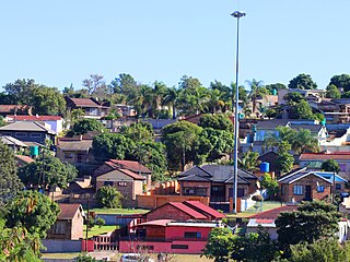
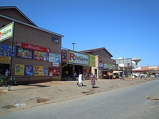
Matsulu is a township in the Mbombela Local Municipality under the Ehlanzeni District Municipality in the Mpumalanga province of South Africa. It lies between Kruger National Park and the N4 national road 41 km east of Nelspruit (Mbombela) CBD, 3 km before the Kaapmuiden train station. It is also surrounded by the Nsikazi River & Crocodile River.

In South Africa some roads are designated as numbered routes to help with navigation. There is a nationwide numbering scheme consisting of national, provincial and regional routes, and within various urban areas there are schemes of metropolitan route numbering.

