 | ||||
|---|---|---|---|---|
| Route information | ||||
| Length | 48.1 km (29.9 mi) | |||
| Major junctions | ||||
| West end | ||||
| East end | ||||
| Location | ||||
| Country | South Africa | |||
| Highway system | ||||
| ||||
The R727 is a Regional Route in Free State, South Africa. [1]
| | ||||
|---|---|---|---|---|
| Route information | ||||
| Length | 48.1 km (29.9 mi) | |||
| Major junctions | ||||
| West end | ||||
| East end | ||||
| Location | ||||
| Country | South Africa | |||
| Highway system | ||||
| ||||
The R727 is a Regional Route in Free State, South Africa. [1]
Its western terminus is the R30 and R59 at Bothaville. It runs east, ending at the R76 between Kroonstad and Viljoenskroon.
South African Airways (SAA) is the flag carrier airline of South Africa. Founded in 1934, the airline is headquartered in Airways Park at O. R. Tambo International Airport in Johannesburg and operated a hub-and-spoke network, serving ten destinations in Africa. The carrier joined Star Alliance in April 2006, making it the first African carrier to sign with one of the three major airline alliances.

O. R. Tambo International Airport is an international airport situated in Kempton Park, Gauteng, South Africa. It serves as the primary airport for domestic and international travel to/from South Africa and since 2020, it is Africa's second busiest airport, with a capacity to handle up to 28 million passengers annually. The airport serves as the hub for South African Airways. The airport handled over 21 million passengers in 2017.

Cape Town International Airport is the primary international airport serving the city of Cape Town, and is the second-busiest airport in South Africa and fourth-busiest in Africa. Located approximately 20 kilometres (12 mi) from the city center, the airport was opened in 1954 to replace Cape Town's previous airport, Wingfield Aerodrome. Cape Town International Airport is the only airport in the Cape Town metropolitan area that offers scheduled passenger services. The airport has domestic and international terminals, linked by a common central terminal.

Mbombela is a city in northeastern South Africa. It is the capital of the Mpumalanga province. Located on the Crocodile River, Mbombela lies about 110 km (68 mi) by road west of the Mozambique border, 330 km (210 mi) east of Johannesburg and 82 km (51 mi) north of the Eswatini border. Mbombela was one of the host cities of the 2010 FIFA World Cup.
The N21 is a proposed national route in South Africa in Cape Town. It mainly forms the Peninsula Expressway ring road. Once complete, it will link the northern suburbs on the Atlantic seaboard with the southern suburbs on False Bay (Muizenberg). The R300 Freeway is entirely part of the proposed route.

National routes in South Africa are a class of trunk roads and freeways which connect major cities. They form the highest category in the South African route numbering scheme, and are designated with route numbers beginning with "N", from N1 to N18. Most segments of the national route network are officially proclaimed National Roads that are maintained by the South African National Roads Agency (SANRAL), but some segments are maintained by provincial or local road authorities.

The N1 is a national route in South Africa that runs from Cape Town through Bloemfontein, Johannesburg, Pretoria and Polokwane to Beit Bridge on the border with Zimbabwe. It forms the first section of the famed Cape to Cairo Road.

Margate is a coastal resort town in the Kwa-Zulu Natal province, about 20 kilometres southwest of Port Shepstone. The river which flows into the sea at Margate is called "Nkhongweni" (place of entreaty) because the original inhabitants were reputed to be so mean that travellers had to beg for hospitality.
Regional routes are the third category of road in the South African route numbering scheme. They are designated with the letter "R" followed by a three-digit number. They serve as feeders connecting smaller towns to the national and provincial routes. Designation as a regional road does not necessarily imply any particular size of road; they range from gravel roads to multi-lane freeways.

The R61 is a long provincial route in South Africa that connects Beaufort West with Port Shepstone via Graaff-Reinet, Komani, Mthatha and Port Edward.

The R102 is a Regional Route in South Africa. It is the route designation for all old sections of the N2, thus it is a discontinuous road that resumes in areas where a new N2 has been constructed.

The R300 or Kuils River Freeway is a Regional Route in the Cape Metropole, South Africa that connects Mitchells Plain with the N2, Kuils River, and the N1 at Bellville. The R300 is a freeway for its entire length; it forms part of the proposed Peninsula Expressway.

Port Elizabeth, officially renamed Gqeberha and colloquially often referred to as P.E., is a major seaport and the most populous city in the Eastern Cape province of South Africa. It is the seat of the Nelson Mandela Bay Metropolitan Municipality, South Africa's second-largest metropolitan district by area size. It is the sixth-most-populous city in South Africa and is the cultural, economic and financial centre of the Eastern Cape.

The N2 is a national route in South Africa that runs from Cape Town through George, Gqeberha, East London, Mthatha and Durban to Ermelo. It is the main highway along the Indian Ocean coast of the country. Its current length of 2,255 kilometres (1,401 mi) makes it the longest numbered route in South Africa.
The N7 is a national route in South Africa that runs from Cape Town northwards through the West Coast and Namaqualand regions to the Namibian border at Vioolsdrif. After crossing the border, it changes designation to B1 and runs north through Windhoek and the north of Namibia.

The N12 is a national route in South Africa which runs from George through Beaufort West, Kimberley, Klerksdorp and Johannesburg to eMalahleni.

The N4 is a national route in South Africa that runs from Skilpadshek on the Botswana border, past Rustenburg, Pretoria, eMalahleni and Mbombela, to Komatipoort on the Mozambique border. It forms the South African section of the Trans-Kalahari Corridor, which runs from Walvis Bay to Maputo, meaning that it links the east and west coasts of Southern Africa. Since the completion of the A2 through Botswana, the entire Corridor is now a world-class standard highway; it features at least one carriageway in each direction of high-speed traffic plus a paved shoulder for its entire length.

In South Africa some roads are designated as numbered routes to help with navigation. There is a nationwide numbering scheme consisting of national, provincial and regional routes, and within various urban areas there are schemes of metropolitan route numbering.
Provincial routes are the second category of road in the South African route-numbering scheme. They are designated with the letter "R" followed by a number from 21 to 82, formerly with the letter "P" followed by a number from 66. They serve as feeders to the national routes and as trunk roads in areas where there is no national route.
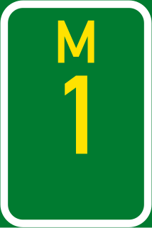
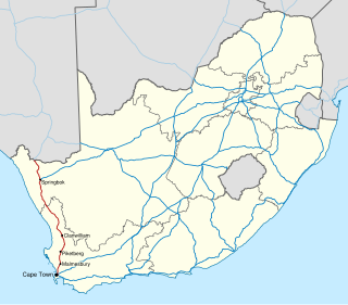
The City of Cape Town like most South African metropolitan areas, uses Metropolitan or "M" routes for important intra-city routes, a layer below National (N) roads and Regional (R) roads. Each city's M roads are independently numbered.
{{cite web}}: CS1 maint: url-status (link)| | This South African road or road transport-related article is a stub. You can help Wikipedia by expanding it. |