RAF High Halden

Last updated

RAF High Halden
USAAF Station AAF-411
Ensign of the Royal Air Force.svg Patch9thusaaf.png
High Halden, Kent in England
Highhalden-jul45.jpg
High Halden airfield, July 1945. The ALG's laid down in southern England had two runways, while the ones laid down in France after the invasion generally had only one strip laid down east-west for speed of construction.
Kent UK location map.svg
Red pog.svg
RAF High Halden
Shown within Kent
United Kingdom adm location map.svg
Red pog.svg
RAF High Halden
RAF High Halden (the United Kingdom)
Coordinates 51°07′17″N000°42′16″E / 51.12139°N 0.70444°E / 51.12139; 0.70444 Coordinates: 51°07′17″N000°42′16″E / 51.12139°N 0.70444°E / 51.12139; 0.70444
Type Advanced Landing Ground
Site information
Owner Air Ministry
Operator United States Army Air Forces 1944
Royal Air Force 1944
Site history
Built1943 (1943)
In use1944-1944 (1944)
Battles/wars European theatre of World War II
Airfield information
Elevation12 metres (39 ft) AMSL
Runways
Direction Length and surface
04/221,353 metres (4,439 ft)  Sommerfeld Tracking
11/291,170 metres (3,839 ft) Sommerfeld Tracking
Republic P-47D-28-RE Thunderbolt Serial 44-20244 of the 367th Fighter Squadron 358fg-p47-hhalden.jpg
Republic P-47D-28-RE Thunderbolt Serial 44-20244 of the 367th Fighter Squadron

Royal Air Force High Halden or more simply RAF High Halden is a former Royal Air Force Advanced Landing Ground in Kent, England. The airfield is located approximately 8 miles (13 km) west-southwest of Ashford; about 50 miles (80 km) southeast of London.

Contents

Opened in 1944, Ashford was a prototype for the type of temporary Advanced Landing Ground type airfield which would be built in France after D-Day, when the need for advanced landing fields would become urgent as the Allied forces moved east across France and Germany. It was used by the United States Army Air Forces. It was closed in September 1944.

Today the airfield is a mixture of agricultural fields with no recognisable remains.

History

The USAAF Ninth Air Force required several temporary Advanced Landing Ground (ALG) along the channel coast prior to the June 1944 Normandy invasion to provide tactical air support for the ground forces landing in France.

USAAF use

High Halden was known as USAAF Station AAF-411 for security reasons by the USAAF during the war, and by which it was referred to instead of location. Its USAAF Station Code was "HH".

358th Fighter Group

An advance party of the 358th Fighter Group [1] moved into High Halden airfield in on 13 April 1944 from RAF Raydon. Operational squadrons of the 358th were:

  • 365th Fighter Squadron [1] (CH)
  • 366th Fighter Squadron [1] (IA)
  • 367th Fighter Squadron [1] (CP)

The group was assigned to the XIX Tactical Air Command, 100th Fighter Wing.

The 358th began movement to the ALG at Cretteville France (ALG A-14) on 29 June, however the group continued to operate from High Halden until 16 July with the remainder of the ground support personnel leaving on the 18th.

Current use

With the facility released from military control the airfield area was returned to the farmers, which put it back into agricultural use.

Today, the area is unrecognizable as an airfield. High Halden's precise location can only be determined by matching the secondary roads in the area with those visible on aerial photography taken during the airfields active use. Close examination of recent aerial photography shows some evidence of scarring on the landscape that still exists, which align with the NE/SW runway. In the local area, a few outward traces remain of the airfield, consisting of some metal PSP that was used for fencing.

A memorial to those who served at the airfield has been erected close to the northern end of the 04/22 runway on Bethersden Road.

See also

Related Research Articles

<span class="mw-page-title-main">RAF Aldermaston</span> Former Royal Air Force station

Royal Air Force Aldermaston or more simply RAF Aldermaston is a former Royal Air Force station located 8 miles (13 km) east of Newbury, Berkshire and 9.8 miles (15.8 km) southwest of Reading, Berkshire, England.

<span class="mw-page-title-main">RAF Raydon</span>

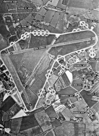
Royal Air Force Raydon or more simply RAF Raydon is a former Royal Air Force station located just to the northeast of the village of Raydon, about 6 miles (9.7 km) from Ipswich, England.

<span class="mw-page-title-main">RAF Ibsley</span> Former Royal Air Force station

Royal Air Force Ibsley or more simply RAF Ibsley is a former Royal Air Force station in Hampshire, England. The airfield is near the village of Ibsley, about 2 miles (3 km) north of Ringwood and about 85 miles (137 km) southwest of London.

<span class="mw-page-title-main">RAF Stoney Cross</span>

Royal Air Force Stoney Cross or more simply RAF Stoney Cross is a former Royal Air Force station in the New Forest, Hampshire, England. The airfield is located approximately 4 miles (6.4 km) northwest of Lyndhurst and 12 miles (19 km) west of Southampton.

<span class="mw-page-title-main">RAF Bisterne</span> Airport in Bisterne, Hampshire

Royal Air Force Bisterne or more simply RAF Bisterne is a former Royal Air Force Advanced Landing Ground in Hampshire, England. The airfield is located in the hamlet of Bisterne approximately 2 miles (3.2 km) south of Ringwood; about 85 miles (137 km) southwest of London.

<span class="mw-page-title-main">RAF Ramsbury</span> Former RAF airbase in England

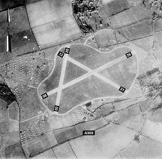
Royal Air Force Ramsbury or more simply RAF Ramsbury is a former Royal Air Force station, 5 miles (8 km) east-northeast of Marlborough, Wiltshire, England.

<span class="mw-page-title-main">Advanced Landing Ground</span> Temporary advance airfields

Advanced Landing Grounds (ALGs) were temporary advance airfields constructed by the Allies during World War II during the liberation of Europe. They were built in the UK prior to the invasion and thereafter in northwest Europe from 6 June 1944 to V-E Day, 7 May 1945.

<span class="mw-page-title-main">RAF Thruxton</span> Airport in Thruxton, Hampshire

Royal Air Force Thruxton or more simply RAF Thruxton is a former Royal Air Force station located 5 miles (8.0 km) west of Andover, Hampshire and about 66 miles (106 km) southwest of London.

<span class="mw-page-title-main">RAF Lymington</span> RAF airbase in England, UK

Royal Air Force Lymington or more simply RAF Lymington is a former Royal Air Force Advanced Landing Ground in Hampshire, England. The airfield is located approximately 1 mile (1.6 km) east of Lymington; about 80 miles (130 km) southwest of London.

<span class="mw-page-title-main">RAF Winkton</span> Former Royal Air Force Advanced Landing Ground

Royal Air Force Winkton or more simply RAF Winkton is a former Royal Air Force Advanced Landing Ground previously in Hampshire but now, due to County boundary changes, in Dorset, England. The airfield is located approximately 3 miles (4.8 km) north of Christchurch; about 89 miles (143 km) southwest of London, and is named after the nearby hamlet of Winkton.

<span class="mw-page-title-main">RAF Kingsnorth (World War II)</span>

Royal Air Force Kingsnorth or more simply RAF Kingsnorth is a former Royal Air Force Advanced Landing Ground in Kent, England. It was at Bliby Corner approximately 2 miles (3.2 km) southeast of Ashford; about 50 miles (80 km) southeast of London. It is not to be confused with RNAS Kingsnorth, later RAF Kingsnorth, which was an airship station in operation during and after the First World War.

<span class="mw-page-title-main">RAF Woodchurch</span>

Royal Air Force Woodchurch or more simply RAF Woodchurch is a former Royal Air Force Advanced Landing Ground located in Kent, England. The airfield is located approximately 5 miles (8.0 km) west of Ashford; about 50 miles (80 km) southeast of London.

<span class="mw-page-title-main">RAF Ashford</span>

Royal Air Force Ashford or more simply RAF Ashford is a former Royal Air Force Advanced Landing Ground in Kent, England. The landing ground is located approximately 3 miles (4.8 km) west of Ashford just south of the A28 near the junction with Old Surrenden Manor Road; about 50 miles (80 km) southeast of London.

<span class="mw-page-title-main">RAF Staplehurst</span>

Royal Air Force Staplehurst or more simply RAF Staplehurst is a former Royal Air Force Advanced Landing Ground located in Kent, England. The airfield is located approximately 1 mile (1.6 km) northeast of Staplehurst; about 38 miles (61 km) southeast of London.

<span class="mw-page-title-main">RAF Merryfield</span>

Royal Air Force Merryfield or more simply RAF Merryfield is a former Royal Air Force station in the village of Ilton near Ilminster in southwest Somerset, England. The airfield is located approximately 7 miles (11 km) north of Chard, about 130 miles (210 km) southwest of London. It is now RNAS Merryfield and serves as a satellite to the larger RNAS Yeovilton; it is used mainly as a training facility for helicopter pilots.

<span class="mw-page-title-main">RAF Weston Zoyland</span> Defunct RAF airbase in England, UK

RAF Westonzoyland is one of the United Kingdom's oldest airfields, being established in the early 1920s. The airfield is located approximately 4 miles (6.4 km) east-southeast of Bridgwater, Somerset; about 125 miles (201 km) west-southwest of London.

<span class="mw-page-title-main">RAF Spanhoe</span> Former Royal Air Force station in Northamptonshire, England

Royal Air Force Spanhoe or more simply RAF Spanhoe is a former Royal Air Force station near Uppingham in Northamptonshire, England. The airfield is located approximately 4 miles (6.4 km) east of Uppingham; about 80 miles (130 km) north-northwest of London

Sint-Truiden / Brustem Airfield is an airfield located in Brustem, 1.5 nautical miles southeast of Sint-Truiden (Limburg) and approximately 37 mi (60 km) east of Brussels. Formerly known as Sint-Truiden Air Base or Brustem Air Base, the aerodrome was deactivated as a Belgian Air Component base in 1996.

<span class="mw-page-title-main">RAF Christchurch</span>

Royal Air Force Christchurch or more simply RAF Christchurch is a former Royal Air Force satellite station and was located southeast of the A337/B3059 junction in Somerford, Christchurch, Dorset, England.

<span class="mw-page-title-main">Headcorn Aerodrome</span> Airport in Ashford, Kent

Headcorn Aerodrome is a private airfield in Kent, England. The airfield is located 8 NM south of Maidstone; about 32 miles (51 km) southeast of London.

References

PD-icon.svg This article incorporates public domain material from the Air Force Historical Research Agency.

Citations

Bibliography