
Royal Air Force Tangmere or more simply RAF Tangmere is a former Royal Air Force station located in Tangmere, England, famous for its role in the Battle of Britain.

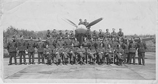
Royal Air Force Syerston, commonly known simply as RAF Syerston, is a Royal Air Force station in the parish of Flintham, near Newark, Nottinghamshire, England. Opened in 1940, it was used by the Royal Air Force (RAF) as a bomber base during the Second World War, operating Vickers Wellingtons, Avro Manchesters, and the Avro Lancaster heavy bombers. Post-war, it became home to Jet Provosts of the 2 Flying Training School. It is now home to the Royal Air Force Central Gliding School.

Royal Air Force Wyton or more simply RAF Wyton is a Royal Air Force station near St Ives, Cambridgeshire, England. The airfield is decommissioned and is now home to the Joint Forces Intelligence Group.
Royal Air Force Ballyhalbert or more simply RAF Ballyhalbert is a former Royal Air Force station at Ballyhalbert on the Ards Peninsula, County Down, Northern Ireland

Royal Air Force West Malling or more simply RAF West Malling is a former Royal Air Force station located 1.6 miles (2.6 km) south of West Malling, Kent and 5.2 miles (8.4 km) west of Maidstone, Kent, England.
Royal Air Force Blackbushe or more simply RAF Blackbushe is a former Royal Air Force station in Hampshire, England, during the Second World War. It is now Blackbushe Airport.

Tain Air Weapons Range is a Ministry of Defence air weapons range on the Dornoch Firth near Tain in Scotland. Royal Air Force aircrews from RAF Lossiemouth are trained in air weaponry on the range, along with NATO aircrew.
Royal Air Force Bircham Newton or more simply RAF Bircham Newton is a former Royal Air Force station located 2.1 miles (3.4 km) south east of Docking, Norfolk and 13.4 miles (21.6 km) north east of King's Lynn, Norfolk, England.
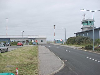
Wick John O' Groats Airport is located one nautical mile north of the town of Wick, at the north-eastern extremity of the mainland of Scotland. It is owned and maintained by Highlands and Islands Airports Limited. The airport provides commercial air travel connections for Caithness, with scheduled services to Aberdeen Airport and, until early 2020, Edinburgh. It remains regularly used by helicopters servicing local offshore oil operations and the Beatrice Offshore Windfarm. It also serves as a stop-over for light aircraft ferry flights between Europe and North America via Iceland. The airport also operates an out of hours call-out service for air ambulances, coastguard and police flights.

Army Aviation Centre (AAC) Middle Wallop is a British Army airfield located near the Hampshire village of Middle Wallop, used for Army Air Corps training. The base hosts 2 (Training) Regiment AAC and 7 (Training) Regiment AAC under the umbrella of the Army Aviation Centre. 2 (Training) Regiment performs ground training; 7 (Training) Regiment trains aircrew on AAC aircraft after they complete basic training at RAF Shawbury.
Royal Air Force Staplehurst or more simply RAF Staplehurst is a former Royal Air Force Advanced Landing Ground located in Kent, England. The airfield is located approximately 1 mile (1.6 km) northeast of Staplehurst; about 38 miles (61 km) southeast of London.

Royal Air Force Westhampnett or more simply RAF Westhampnett is a former Royal Air Force satellite station, located in the village of Westhampnett near Chichester, in the English County of West Sussex.

Royal Air Force Detling, or more simply RAF Detling, is a former Royal Air Force station situated 600 feet (180 m) above sea level, located near Detling, a village about 4 miles (6.4 km) miles north-east of Maidstone, Kent.

Royal Air Force Acklington, simply known as RAF Acklington, is a former Royal Flying Corps and Royal Air Force station located 3.2 miles (5.1 km) south west of Amble, Northumberland and 8.8 miles (14.2 km) north east of Morpeth, Northumberland.
Lod Air Force Base, also Air Force Base 27, was an Israeli Air Force airfield that was part of the Ben Gurion International Airport, located approximately 7 km (4 mi) north of Lod; 8 km (5 mi) east-southeast of Tel Aviv.

Royal Air Force Hawkinge or more simply RAF Hawkinge is a former Royal Air Force station located 13.23 miles (21.29 km) east of Ashford, 2.2 miles (3.5 km) north of Folkestone, Kent and 7.1 miles (11.4 km) west of Dover, Kent, England. The airfield was used by both the Royal Flying Corps and the Royal Air Force during its lifetime and was involved during the Battle of Britain, as well as other important aerial battles during the Second World War and the early stages of aerial usage in war in the First World War.
Royal Air Force Angle or more commonly RAF Angle, is a former Royal Air Force station located on the Angle Peninsula Coast, 8 miles (13 km) west of Pembroke, Pembrokeshire, Wales. It was operational from 1 June 1941 to 11 July 1946, having been used by both the Royal Air Force and the Royal Navy.

Royal Air Force Culmhead or more simply RAF Culmhead is a former Royal Air Force station, situated at Churchstanton on the Blackdown Hills in Somerset, England.

Royal Air Force Charterhall or more simply RAF Charterhall is a former Royal Air Force station located in the Scottish Borders and the historic county of Berwickshire between the village of Greenlaw and Duns. It was originally a First World War landing ground named Eccles Toft. The airfield was reconstructed in 1942 and was used mainly by No. 54 Operational Training Unit during Second World War. The RAF left in 1947 and the airfield was officially closed.
Royal Air Force Headcorn or more commonly known as RAF Headcorn is a former Royal Air Force Advanced Landing Ground located 2 miles (3.2 km) northeast of Headcorn, Kent, England.


