Related Research Articles

A communications satellite is an artificial satellite that relays and amplifies radio telecommunication signals via a transponder; it creates a communication channel between a source transmitter and a receiver at different locations on Earth. Communications satellites are used for television, telephone, radio, internet, and military applications. Many communications satellites are in geostationary orbit 22,300 miles (35,900 km) above the equator, so that the satellite appears stationary at the same point in the sky; therefore the satellite dish antennas of ground stations can be aimed permanently at that spot and do not have to move to track the satellite. Others form satellite constellations in low Earth orbit, where antennas on the ground have to follow the position of the satellites and switch between satellites frequently.

Vanguard 1 is an American satellite that was the fourth artificial Earth-orbiting satellite to be successfully launched, following Sputnik 1, Sputnik 2, and Explorer 1. It was launched 17 March 1958. Vanguard 1 was the first satellite to have solar electric power. Although communications with the satellite were lost in 1964, it remains the oldest human-made object still in orbit, together with the upper stage of its launch vehicle.

Radio navigation or radionavigation is the application of radio frequencies to determine a position of an object on the Earth, either the vessel or an obstruction. Like radiolocation, it is a type of radiodetermination.

A microwave radiometer (MWR) is a radiometer that measures energy emitted at one millimeter-to-metre wavelengths (frequencies of 0.3–300 GHz) known as microwaves. Microwave radiometers are very sensitive receivers designed to measure thermally-emitted electromagnetic radiation. They are usually equipped with multiple receiving channels to derive the characteristic emission spectrum of planetary atmospheres, surfaces or extraterrestrial objects. Microwave radiometers are utilized in a variety of environmental and engineering applications, including remote sensing, weather forecasting, climate monitoring, radio astronomy and radio propagation studies.
Radar astronomy is a technique of observing nearby astronomical objects by reflecting radio waves or microwaves off target objects and analyzing their reflections. Radar astronomy differs from radio astronomy in that the latter is a passive observation and the former an active one. Radar systems have been conducted for six decades applied to a wide range of Solar System studies. The radar transmission may either be pulsed or continuous. The strength of the radar return signal is proportional to the inverse fourth-power of the distance. Upgraded facilities, increased transceiver power, and improved apparatus have increased observational opportunities.

Project Echo was the first passive communications satellite experiment. Each of the two American spacecraft, launched in 1960 and 1964, were metalized balloon satellites acting as passive reflectors of microwave signals. Communication signals were transmitted from one location on Earth and bounced off the surface of the satellite to another Earth location.

Satellite geodesy is geodesy by means of artificial satellites—the measurement of the form and dimensions of Earth, the location of objects on its surface and the figure of the Earth's gravity field by means of artificial satellite techniques. It belongs to the broader field of space geodesy. Traditional astronomical geodesy is not commonly considered a part of satellite geodesy, although there is considerable overlap between the techniques.
The United States Space Surveillance Network (SSN) detects, tracks, catalogs and identifies artificial objects orbiting Earth, e.g. active/inactive satellites, spent rocket bodies, or fragmentation debris. The system is the responsibility of United States Space Command and operated by the United States Space Force.
Passive radar is a class of radar systems that detect and track objects by processing reflections from non-cooperative sources of illumination in the environment, such as commercial broadcast and communications signals. It is a specific case of bistatic radar – passive bistatic radar (PBR) – which is a broad type also including the exploitation of cooperative and non-cooperative radar transmitters.
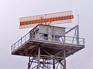
Secondary surveillance radar (SSR) is a radar system used in air traffic control (ATC), that unlike primary radar systems that measure the bearing and distance of targets using the detected reflections of radio signals, relies on targets equipped with a radar transponder, that reply to each interrogation signal by transmitting encoded data such as an identity code, the aircraft's altitude and further information depending on its chosen mode. SSR is based on the military identification friend or foe (IFF) technology originally developed during World War II, therefore the two systems are still compatible. Monopulse secondary surveillance radar (MSSR), Mode S, TCAS and ADS-B are similar modern methods of secondary surveillance.
A balloon satellite, sometimes referred to as a "satelloon", is inflated with gas after it has been put into orbit.

The Atmospheric Neutral Density Experiment (ANDE) is an experiment using two spherical satellites to measure the effects of atmospheric drag on spacecraft. ANDE is part of the Space Test Program of the United States Department of Defense, and was deployed in September 2006 from the Space Shuttle Discovery.
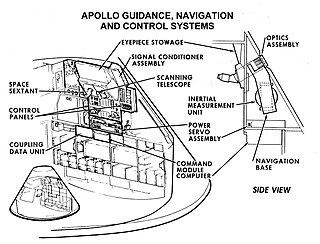
Guidance, navigation and control is a branch of engineering dealing with the design of systems to control the movement of vehicles, especially, automobiles, ships, aircraft, and spacecraft. In many cases these functions can be performed by trained humans. However, because of the speed of, for example, a rocket's dynamics, human reaction time is too slow to control this movement. Therefore, systems—now almost exclusively digital electronic—are used for such control. Even in cases where humans can perform these functions, it is often the case that GNC systems provide benefits such as alleviating operator work load, smoothing turbulence, fuel savings, etc. In addition, sophisticated applications of GNC enable automatic or remote control.
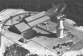
The Unified S-band (USB) system is a tracking and communication system developed for the Apollo program by NASA and the Jet Propulsion Laboratory (JPL). It operated in the S band portion of the microwave spectrum, unifying voice communications, television, telemetry, command, tracking and ranging into a single system to save size and weight and simplify operations. The USB ground network was managed by the Goddard Space Flight Center (GSFC). Commercial contractors included Collins Radio, Blaw-Knox, Motorola and Energy Systems.

GEOS-3, or Geodynamics Experimental Ocean Satellite 3, or GEOS-C, was the third and final satellite as part of NASA's Geodetic Earth Orbiting Satellite/Geodynamics Experimental Ocean Satellite program (NGSP) to better understand and test satellite tracking systems. For GEOS 1 and GEOS 2, the acronym stands for Geodetic Earth Orbiting Satellite; this was changed for GEOS-3.
The Lincoln Calibration Sphere 1, or LCS-1, is a large aluminium sphere in Earth orbit since 6 May 1965. It is still in use, having lasted for over 50 years. The sphere was launched along with the Lincoln Experimental Satellite-2 on a Titan IIIA. It is technically the oldest operational spacecraft, but it has no power supply or fuel; it is merely a passive metal sphere. LCS-1 has been used for radar calibration since its launch. It was built by Rohr. Corp. for the MIT Lincoln Laboratory.
ODERACS-2 was a series of six spheres deployed from the shuttle mission STS-63, ODERACS-2A through -2. The purpose of the Orbital Debris Radar Calibration Sphere experiment was to calibrate the radars and telescopes used for orbital debris measurements by putting passive objects of known size and shape into orbit. The objects were 2, 4, and 6 inch spheres and three wire dipoles.
Explorer 36 was a NASA satellite launched as part of the Explorer program, being the second of the two satellites GEOS. Explorer 36 was launched on 11 January 1968 from Vandenberg Air Force Base, with Thor-Delta E1 launch vehicle.

Lincoln Experimental Satellite 2, also known as LES-2, was a communications satellite, the second of nine in the Lincoln Experimental Satellite. Launched by the United States Air Force (USAF) on 6 May 1965, it demonstrated many then-advanced technologies including active use of the military's SHF band to service hundreds of users.
The Surveillance Calibration satellites were a series of radar calibration satellites for the Naval Space Surveillance radar system. They were launched in the 1960s.
References
- ↑ Mochan, J; Stophel, R. A. (1968). "Dynamic Calibration of Space Object Tracking Systems". The Space Congress Proceedings. 1: 1.1–1. Retrieved 12 October 2021.
- ↑ Sui, Yun; Fu, Haiyang; Xu, Feng (December 2018). "C-Band ISAR Imaging for the Precision Expandable Radar Calibration Sphere". 2018 12th International Symposium on Antennas, Propagation and EM Theory (ISAPE): 1–4. doi:10.1109/ISAPE.2018.8634235. ISBN 978-1-5386-7302-7. S2CID 59620160 . Retrieved 14 July 2022.
- ↑ Bernhardt, Paul A.; Siefring, Carl L.; Thomason, Joe F.; Rodriquez, Serafin P.; Nicholas, Andrew C.; Koss, Steven M.; Nurnberger, Mike; Hoberman, Chuck; Davis, Matthew; Hysell, David L.; Kelley, Michael C. (February 2008). "Design and applications of a versatile HF radar calibration target in low Earth orbit: HF RADAR CALIBRATION TARGET IN ORBIT". Radio Science. 43 (1). doi: 10.1029/2007RS003692 .
- ↑ "Ho'oponopono - eoPortal Directory - Satellite Missions". directory.eoportal.org. Retrieved 14 July 2022.
- ↑ Lawrence, Taylor. "Satellite's operation time exceeds expectations". Kirtland Air Force Base. 377th Air Base Wing Public Affairs. Retrieved 18 October 2021.