
A radome is a structural, weatherproof enclosure that protects a radar antenna. The radome is constructed of material transparent to radio waves. Radomes protect the antenna from weather and conceal antenna electronic equipment from view. They also protect nearby personnel from being accidentally struck by quickly rotating antennas.

Naval Air Station Fallon or NAS Fallon is the United States Navy's premier air-to-air and air-to-ground training facility. It is located southeast of the city of Fallon, east of Reno in western Nevada. Since 1996, it has been home to the U.S. Navy-Fighter Weapons School (TOPGUN) taking over from the former NAS Miramar, California, and the surrounding area contains 240,000 acres (97,000 ha) of bombing and electronic warfare ranges. It is also home to the Naval Aviation Warfighting Development Center (NAWDC), which includes TOPGUN, the Carrier Airborne Early Warning Weapons School (CAEWWS) and the Navy Rotary Wing Weapons School. Navy SEAL Combat Search and Rescue (CSAR) training also takes place there.
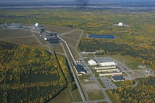
Clear Space Force Station is a United States Space Force radar station for detecting incoming ICBMs and submarine-launched ballistic missiles to NORAD's command center and to provide Space Surveillance data to the United States Space Force. Clear's AN/FPS-123 Upgraded Early Warning Radar is part of the Solid State Phased Array Radar System (SSPARS) which also includes those at Beale AFB, Cape Cod Space Force Station, RAF Fylingdales and Thule Site J. The "historic property" was one of the Alaska World War II Army Airfields and later a Cold War BMEWS site providing NORAD data to Colorado's BMEWS Central Computer and Display Facility (CC&DF).

The Alaskan Air Command (AAC) is an inactive United States Air Force Major Command originally established in 1942 under the United States Army Air Forces. Its mission was to organize and administer the air defense system of Alaska, exercise direct control of all active measures, and coordinate all passive means of air defense. In addition, the command also supported Strategic Air Command elements operating through and around Alaska. It was redesignated Eleventh Air Force on 9 August 1990 and, concurrently, status changed from a major command of the United States Air Force to a subordinate organization of Pacific Air Forces.

Aerospace Defense Command was a major command of the United States Air Force, responsible for air defense of the continental United States. It was activated in 1968 and disbanded in 1980. Its predecessor, Air Defense Command, was established in 1946, briefly inactivated in 1950, reactivated in 1951, and then redesignated Aerospace rather than Air in 1968. Its mission was to provide air defense of the Continental United States (CONUS). It directly controlled all active measures, and was tasked to coordinate all passive means of air defense.

An airport surveillance radar (ASR) is a radar system used at airports to detect and display the presence and position of aircraft in the terminal area, the airspace around airports. It is the main air traffic control system for the airspace around airports. At large airports it typically controls traffic within a radius of 60 miles (96 km) of the airport below an elevation of 25,000 feet. The sophisticated systems at large airports consist of two different radar systems, the primary and secondary surveillance radar. The primary radar typically consists of a large rotating parabolic antenna dish that sweeps a vertical fan-shaped beam of microwaves around the airspace surrounding the airport. It detects the position and range of aircraft by microwaves reflected back to the antenna from the aircraft's surface. The secondary surveillance radar consists of a second rotating antenna, often mounted on the primary antenna, which interrogates the transponders of aircraft, which transmits a radio signal back containing the aircraft's identification, barometric altitude, and an emergency status code, which is displayed on the radar screen next to the return from the primary radar.
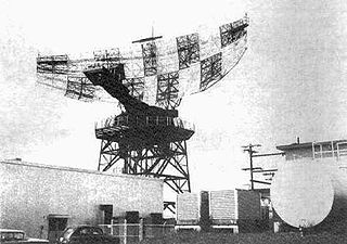
The AN/FPS-35 frequency diversity radar was a long range search radar used in the early 1960s. It was one of the largest air defense radars ever produced, with its antenna and supporting structure mounted on one of the largest rolling-element bearings in the world.

Fort Fisher Air Force Station was a United States Air Force installation located on the Atlantic coast 0.8 miles (1.3 km) southwest of Kure Beach, North Carolina. Its primary mission was as a radar complex. It was closed on 30 June 1988 by the Air Force, and turned over to the Federal Aviation Administration (FAA).
Montauk Air Force Station was a US military base at Montauk Point on the eastern tip of Long Island, New York. It was decommissioned in 1981 and is now owned by the New York State Office of Parks, Recreation and Historic Preservation as Camp Hero State Park.
Mount Hebo Air Force Station is a closed United States Air Force General Surveillance Radar station. It is located 5.2 miles (8.4 km) east-southeast of Hebo, Oregon, located at the top of 3,154-foot (961 m) Mount Hebo. It was closed in 1980.

The 689th Radar Squadron is an inactive United States Air Force unit. It was last assigned to the 25th Air Division, stationed at Mount Hebo Air Force Station, Oregon. It was inactivated on 30 June 1979.

Fortuna Air Force Station is a closed United States Air Force General Surveillance Radar station. It is located 4.2 miles (6.8 km) west of Fortuna, North Dakota. It was closed in 1979 as a radar station, remaining as a Long-Range Radar (LRR) facility until 1984.

North Truro Air Force Station (AFS) is a closed United States Air Force General Surveillance Radar station. It is located 2.2 mi (3.5 km) east of North Truro, Massachusetts.

Texas Tower 2 was a former United States Air Force Texas Tower General Surveillance Radar station, first operational in 1955. It was located 110 miles (180 km) east of Cape Cod, Massachusetts, in 56 feet (17 m). The tower was closed in 1963 and dismantled.

Ground Equipment Facility QRC is an FAA radar station that was part of a Cold War SAGE radar station for aircraft control and warning "from Massachusetts to southern Virginia, and as far out to sea as possible." Benton AFS was also the first operational "regional data processing center" for the GE 477L Nuclear Detection and Reporting System.
The SAGE radar stations of Air Defense Command were the military installations operated by USAF squadrons using the first automated air defense environment and networked by the SAGE System, a computer network. Most of the radar stations used the Burroughs AN/FST-2 Coordinate Data Transmitting Set (CDTS) to automate the operator environment and provide radar tracks to sector command posts at SAGE Direction Centers (DCs), e.g., the Malmstrom Z-124 radar station was co-located with DC-20. The sector/division radar stations were networked by DCs and Manual Control Centers to provide command, control, and coordination for ground-controlled interception of enemy aircraft by interceptors such as the F-106 developed to work with the SAGE System.
The AN/FPS-24 Radar was a long range early warning radar used by the United States Air Force Air Defense Command. It used a two-frequency signal in order to avoid fluctuation loss, which causes signals on single-frequency radars to fade in and out as the target moves. Reducing this effect results in a much steadier signal.
Cambria Air Force Station is a closed United States Air Force General Surveillance Radar station. It is 3 miles (4.8 km) south-southeast of Cambria, California. It was closed in 1980.
Cottonwood Air Force Station is a former United States Air Force General Surveillance Radar station. The radar site was located at the summit of Cottonwood Butte, 5.7 miles (9.2 km) west-northwest of Cottonwood in Idaho County, Idaho. It was closed in 1965 and transferred to the state of Idaho in 1974, when it was converted to its present use as a minimum-security correctional facility.

The Fort Heath radar station was a USAF radar site and US Army Missile Master installation of the joint-use site system (JUSS) for North American Air Defense at a former coastal defense site. The Cold War radar station had 2 USAF AN/FPS-6B height finding radars, 2 Army AN/FPS-6A height finders, an FAA ARSR-1 radar emplaced 1958-9, and an Army nuclear bunker. Arctic Towers were the pedestals for the FPS antennas and radomes, while the Air Route Surveillance Radar was on a 50-foot extension temperate tower adjacent to the Federal Aviation Administration building.

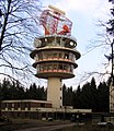 Tower with en route radar at Neunkircher Höhe in the Odenwald
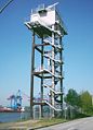 Radar tower for monitoring shipping on the South Elbe river opposite the Altenwerder Container Terminal, Hamburg
 The Former Weesow radar tower in Werneuchen
 Radar station on a mountain in France


