
Augusta State Airport is a public use airport located one nautical mile (2 km) west of the central business district of the state capital of Augusta, a city in Kennebec County, Maine, United States. The airport is owned by the state of Maine, but managed and operated by the city of Augusta. It is served by one commercial airline, with scheduled passenger service subsidized by the Essential Air Service program.

Knox County Regional Airport is a county-owned, public-use airport in the town of Owls Head, Knox County, Maine, United States. It is located three nautical miles (6 km) south of the central business district of Rockland, Maine. The airport serves the residents of midcoast Maine with commercial and charter aviation services. Scheduled airline service is subsidized by the Essential Air Service program. It is also a major hub of freight and mail service to Maine's island communities including Matinicus, North Haven and Vinalhaven.

Laramie Regional Airport is three miles west of Laramie, in Albany County, Wyoming. It is owned by the Laramie Regional Airport Board. Airline service is subsidized by the Essential Air Service program.

Bradford Regional Airport is 11 miles south of Bradford, in Lafayette Township, McKean County, Pennsylvania. It has scheduled airline service subsidized by the Essential Air Service program.

Altoona–Blair County Airport is in Martinsburg, Pennsylvania, 14 miles south of Altoona, in Blair County, Pennsylvania. It is owned by the Blair County Airport Authority. The airport has a few airline flights, subsidized by the Essential Air Service program.
Athens–Ben Epps Airport is a county-owned, public-use airport located three nautical miles (6 km) east of the central business district of Athens, a city in Clarke County, Georgia, United States. The airport is named after Ben T. Epps, the first aviator in the state of Georgia, who opened the airport in 1917. It is mostly used for general aviation, though it was formerly served by one commercial airline with scheduled passenger service subsidized by the Essential Air Service program.

North Central West Virginia Airport is a public/military airport a mile northeast of Bridgeport and six miles east of Clarksburg, in Harrison County, West Virginia, United States. It is owned and operated by the Benedum Airport Authority, serving Harrison and Marion County, and was formerly Benedum Airport and Harrison-Marion Regional Airport. The airport sees two airlines, with some passenger service subsidized by the Essential Air Service program.
Mercer County Airport is in Mercer County, three miles northeast of Bluefield, West Virginia and about nine miles southwest of Princeton, West Virginia. The National Plan of Integrated Airport Systems for 2011–2015 categorized it as a general aviation facility.
Morgantown Municipal Airport is three miles east of Morgantown, in Monongalia County, West Virginia. It is also known as Walter L. Bill Hart Field. It sees one passenger airline, Southern Airways Express, subsidized by the Essential Air Service program.

Mid-Ohio Valley Regional Airport is seven miles northeast of Parkersburg, in Wood County, West Virginia. It is owned by the Wood County Airport Authority and is also known as Wood County Airport or Gill Robb Wilson Field. It serves the Mid-Ohio Valley area which includes the Ohio cities of Marietta and Belpre and the West Virginia cities of Williamstown, Parkersburg and Vienna. It has scheduled passenger service subsidized by the Essential Air Service program.

Watertown International Airport is in the Town of Hounsfield in Jefferson County, New York, United States, 6 mi west of Watertown. The airport is used for general aviation, but has scheduled passenger service subsidized by the Essential Air Service program. The airport has no scheduled international passenger flights, but is available as an international port of entry for private aircraft on two hours' advance notice from pilots.
Shenandoah Valley Regional Airport is in Weyers Cave, Virginia, United States, 12 miles (19 km) northeast of Staunton. It is used for general aviation and is served by one airline, subsidized by the Essential Air Service program.
DuBois Regional Airport, formerly DuBois–Jefferson County Airport, is in Jefferson County, Pennsylvania, eight miles northwest of DuBois, a city in Clearfield County. The airport is in Washington Township. It is owned and operated by the Clearfield-Jefferson Counties Regional Airport Authority, based at the airport. It has scheduled service on one airline, Southern Airways Express, subsidized by the Essential Air Service program.
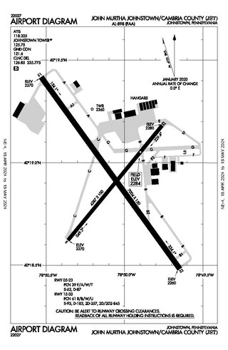
John Murtha Johnstown–Cambria County Airport is a civil-military airport three miles (5 km) northeast of Johnstown, in Cambria County, Pennsylvania. It is owned by Johnstown–Cambria County Airport Authority and is named after the late Congressman John Murtha. It sees one airline, subsidized by the Essential Air Service.

Wrangell Airport is a state-owned public-use airport located one nautical mile (2 km) northeast of the central business district of Wrangell, a city and borough in the U.S. state of Alaska which has no road access to the outside world. Scheduled airline service is subsidized by the Essential Air Service program.
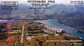
Petersburg James A. Johnson Airport is a state owned, public use airport located one nautical mile (2 km) southeast of the central business district of Petersburg, a city in the Petersburg Borough of the U.S. state of Alaska that has no road access to the outside world. Airline service is subsidized by the Essential Air Service program.

Yakutat Airport is a state-owned public-use airport located three nautical miles (6 km) southeast of the central business district of Yakutat, a city and borough in the U.S. state of Alaska which has no road access to the outside world. Airline service is subsidized by the Essential Air Service program.
Chautauqua County/Jamestown Airport at Robert H. Jackson Field is a county-owned, public-use airport located three nautical miles (6 km) north of the central business district of Jamestown, in Chautauqua County, New York, United States. It is mostly used for general aviation.
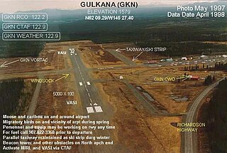
Gulkana Airport is a state owned, public use airport located four nautical miles northeast of the central business district of Gulkana, in the Valdez-Cordova Census Area of the U.S. state of Alaska. It is also and five miles (8 km) northeast of Glenallen. Scheduled passenger service is subsidized by the Essential Air Service program.
Excursion Inlet Seaplane Base is a state owned, public use seaplane base located in Excursion Inlet, in the Haines Borough of the U.S. state of Alaska. Scheduled passenger service is subsidized by the U.S. Department of Transportation via the Essential Air Service program.

