Ravinia, South Dakota

Last updated

Ravinia, South Dakota
Town
Charles Mix County South Dakota Incorporated and Unincorporated areas Ravinia Highlighted.svg
Location in Charles Mix County and the state of South Dakota
Coordinates: 43°08′11″N98°25′37″W / 43.13639°N 98.42694°W / 43.13639; -98.42694
CountryUnited States
State South Dakota
County Charles Mix
Incorporated1910 [1]
Area
[2]
  Total0.25 sq mi (0.64 km2)
  Land0.25 sq mi (0.64 km2)
  Water0.00 sq mi (0.00 km2)
Elevation
[3]
1,499 ft (457 m)
Population
 (2020) [4]
  Total71
  Density286.29/sq mi (110.65/km2)
Time zone UTC-6 (Central (CST))
  Summer (DST) UTC-5 (CDT)
ZIP code
57356
Area code 605
FIPS code 46-53220 [5]
GNIS feature ID1267545 [3]

Ravinia is a town in Charles Mix County, South Dakota, United States. The population was 71 at the 2020 census. [6]

Contents

Ravinia was laid out in 1909. [7]

Geography

According to the United States Census Bureau, the town has a total area of 0.25 square miles (0.65 km2), all land. [8]

Transportation

Demographics

Historical population
CensusPop.Note
1910 81
1920 199145.7%
1930 157−21.1%
1940 155−1.3%
1950 20029.0%
1960 164−18.0%
1970 109−33.5%
1980 88−19.3%
1990 79−10.2%
2000 790.0%
2010 61−22.8%
2020 7116.4%
U.S. Decennial Census [9] [4]

2010 census

As of the census [10] of 2010, there were 61 people, 22 households, and 14 families living in the town. The population density was 244.0 inhabitants per square mile (94.2/km2). There were 36 housing units at an average density of 144.0 per square mile (55.6/km2). The racial makeup of the town was 24.6% White, 3.3% African American, 65.6% Native American, 1.6% from other races, and 4.9% from two or more races. Hispanic or Latino of any race were 6.6% of the population.

There were 22 households, of which 27.3% had children under the age of 18 living with them, 36.4% were married couples living together, 18.2% had a female householder with no husband present, 9.1% had a male householder with no wife present, and 36.4% were non-families. 36.4% of all households were made up of individuals, and 13.6% had someone living alone who was 65 years of age or older. The average household size was 2.77 and the average family size was 3.57.

The median age in the town was 38.5 years. 36.1% of residents were under the age of 18; 6.5% were between the ages of 18 and 24; 9.7% were from 25 to 44; 34.4% were from 45 to 64; and 13.1% were 65 years of age or older. The gender makeup of the town was 47.5% male and 52.5% female.

2000 census

As of the census [5] of 2000, there were 79 people, 26 households, and 17 families living in the town. The population density was 317.2 inhabitants per square mile (122.5/km2). There were 33 housing units at an average density of 132.5 per square mile (51.2/km2). The racial makeup of the town was 22.78% White, 70.89% Native American, 3.80% from other races, and 2.53% from two or more races. Hispanic or Latino of any race were 3.80% of the population.

There were 26 households, out of which 30.8% had children under the age of 18 living with them, 42.3% were married couples living together, 15.4% had a female householder with no husband present, and 34.6% were non-families. 34.6% of all households were made up of individuals, and 15.4% had someone living alone who was 65 years of age or older. The average household size was 3.04 and the average family size was 3.76.

In the town, the population was spread out, with 35.4% under the age of 18, 15.2% from 18 to 24, 12.7% from 25 to 44, 29.1% from 45 to 64, and 7.6% who were 65 years of age or older. The median age was 24 years. For every 100 females, there were 125.7 males. For every 100 females age 18 and over, there were 142.9 males.

The median income for a household in the town was $27,000, and the median income for a family was $27,000. Males had a median income of $25,417 versus $17,083 for females. The per capita income for the town was $10,310. There were 16.7% of families and 24.7% of the population living below the poverty line, including 30.8% of under eighteens and none of those over 64.

Related Research Articles

<span class="mw-page-title-main">Hoople, North Dakota</span> City in North Dakota, United States

Hoople is a city in Walsh County, North Dakota, United States. The population was 247 at the 2020 census. Hoople, named for early settler Alan Hoople, was founded in 1889. Hoople's nickname is "Tater Town."

<span class="mw-page-title-main">Westport, South Dakota</span> Town in South Dakota, United States

Westport is a town in western Brown County, South Dakota, United States. The population was 88 at the 2020 census.

<span class="mw-page-title-main">Lake Andes, South Dakota</span> City in South Dakota, United States

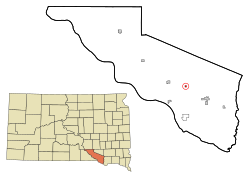
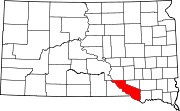
Lake Andes is a city in, and the county seat of, Charles Mix County, South Dakota, United States. The population was 710 at the 2020 census.

<span class="mw-page-title-main">Wagner, South Dakota</span> City in South Dakota, United States

Wagner is a city in Charles Mix County, South Dakota, United States. The population was 1,490 at the 2020 census. The city is served by Wagner Municipal Airport as well as YST Transit buses.

<span class="mw-page-title-main">Florence, South Dakota</span> Town in South Dakota, United States

Florence is a town in northwestern Codington County, South Dakota, United States. It is part of the Watertown, South Dakota Micropolitan Statistical Area. The population was 337 at the 2020 census.

<span class="mw-page-title-main">Ethan, South Dakota</span> Town in South Dakota, United States

Ethan is a town in Davison County, South Dakota, United States. It is part of the Mitchell, South Dakota Micropolitan Statistical Area. The population was 365 at the 2020 census. Ethan is located 10 miles south of Mitchell.

<span class="mw-page-title-main">Isabel, South Dakota</span> Town in South Dakota, United States

Isabel is a town in Dewey County, South Dakota, United States. The population was 145 at the 2020 census.

<span class="mw-page-title-main">Milbank, South Dakota</span> City in South Dakota, United States

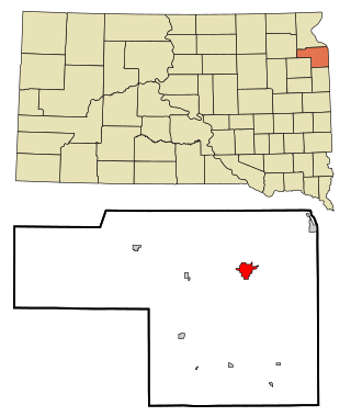
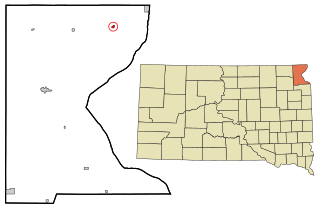
Milbank is a city in Grant County, South Dakota, United States, located along the South Fork of the Whetstone River. The population was 3,544 at the 2020 census. It is the county seat of Grant County. Milbank is the birthplace of American Legion Baseball. The program was created in Milbank in 1925 and is now enjoyed by high school aged youth on more than five thousand teams in all fifty states.

<span class="mw-page-title-main">Strandburg, South Dakota</span> Town in South Dakota, United States

Strandburg is a town in southern Grant County, South Dakota, United States. The population was 63 at the 2020 census. Its name is derived from the town's founder, the Swedish John Strandburg.

<span class="mw-page-title-main">Harrold, South Dakota</span> Town in South Dakota, United States

Harrold is a town in Hughes County, South Dakota, United States. It is part of the Pierre, South Dakota Micropolitan Statistical Area. The population was 101 at the 2020 census.

<span class="mw-page-title-main">Parkston, South Dakota</span> City in South Dakota, United States

Parkston is a city in Hutchinson County, South Dakota, United States. The population was 1,567 at the 2020 census.

<span class="mw-page-title-main">Whitewood, South Dakota</span> City in South Dakota, United States

Whitewood is a city in Lawrence County, South Dakota, United States. The population was 879 at the 2020 census.

<span class="mw-page-title-main">Hudson, South Dakota</span> Town in South Dakota, United States

Hudson is a town in Lincoln County, South Dakota, United States. The population was 311 at the 2020 census. It is the easternmost community in South Dakota.

<span class="mw-page-title-main">Carthage, South Dakota</span> City in South Dakota, United States

Carthage is a city in Miner County, South Dakota, United States. The population was 127 at the 2020 census.

<span class="mw-page-title-main">Ortley, South Dakota</span> Town in South Dakota, United States

Ortley is a town in Roberts County, South Dakota, United States. The population was 50 according to the 2020 census.

<span class="mw-page-title-main">Peever, South Dakota</span> Town in South Dakota, United States

Peever is a town in Roberts County, South Dakota, United States. The population was 180 at the 2020 census.

<span class="mw-page-title-main">Rosholt, South Dakota</span> Town in South Dakota, United States

Rosholt is a town in Roberts County, South Dakota, United States. The population was 379 at the 2020 census.

<span class="mw-page-title-main">Dolton, South Dakota</span> Town in South Dakota, United States

Dolton is a town in Turner County, South Dakota, United States. The population was 34 at the 2020 census.

<span class="mw-page-title-main">Elk Point, South Dakota</span> City in South Dakota, United States

Elk Point is a city in and county seat of Union County, South Dakota, United States. The population was 2,149 as of the 2020 census.

<span class="mw-page-title-main">Lesterville, South Dakota</span> Town in South Dakota, United States

Lesterville is a town in Yankton County, South Dakota, United States. The population was 115 at the 2020 census.

References

  1. "SD Towns" (PDF). South Dakota State Historical Society . Retrieved February 15, 2010.
  2. "ArcGIS REST Services Directory". United States Census Bureau. Retrieved October 15, 2022.
  3. 1 2 U.S. Geological Survey Geographic Names Information System: Ravinia, South Dakota
  4. 1 2 "Census Population API". United States Census Bureau. Retrieved October 15, 2022.
  5. 1 2 "U.S. Census website". United States Census Bureau . Retrieved January 31, 2008.
  6. "U.S. Census Bureau: Ravinia town, South Dakota". www.census.gov. United States Census Bureau. Retrieved February 5, 2022.
  7. Federal Writers' Project (1940). South Dakota place-names, v.1-3. University of South Dakota. p. 58.
  8. "US Gazetteer files 2010". United States Census Bureau. Archived from the original on January 25, 2012. Retrieved June 21, 2012.
  9. "Census of Population and Housing". Census.gov. Retrieved June 4, 2015.
  10. "U.S. Census website". United States Census Bureau . Retrieved June 21, 2012.