Ray's Ferry

Last updated
Ferry License Reuben Ray Ferry Permit 1816.jpg
Ferry License
Site of Ray's Ferry Today Rays Ferry LA.jpg
Site of Ray's Ferry Today

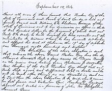
Ray's Ferry in Louisiana, United States, is the point along Bayou Boeuf in Avoyelles Parish, at which the road between Opelousas and Marksville crossed the waterway. A ferry service operated here from 1816. It is unknown how long the ferry was in service. The name comes from the individual, Reuben Ray, licensed to operate the ferry service. Ray was granted a permit from the State of Louisiana on September 19, 1816, to "keep a ferry across the Bayou Boeuf on the main road leading from Opelousas to Avoyelles". The permit can be inspected at the Court Archives of Saint Landry Parish, Courthouse, Opelousas, LA.

In 1816, the main road from Opelousas to Avoyelles Courthouse served as an important connection between North and South Louisiana. The streams and bayous of this region were formidable barriers to over land travel. Bridge crossings were not only very expensive to build and maintain but obstacles to waterborne commerce. In order to encourage immigration and settlement of the new state, adjacent property owners along the few main roads that existed were often enlisted to provide a means of crossing nearby streams. These ferry crossings or landings became integral links in the developing road network.

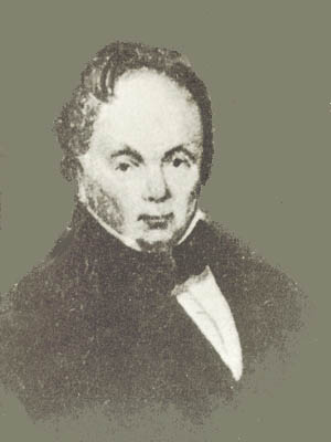
Reuben Ray and family acquired about 640 acres along the east bank of Bayou Boeuf in 1812 three miles from the closest settlement, which was Cheneyville. [1] James Bowie was a close neighbor between 1814 and 1816. Then a young man, he survived by cutting timber and barging it down the bayou to be sold in New Orleans. Years later he became a hero of the Texas Revolution dying in the siege of the Alamo. [2] But, cultivation of cotton and corn were the staple crops supporting the Ray family. Around 1846 reversals in family finances forced sale of land holdings along the bayou and the family removed to southwest Rapides Parish near Glenmora. [3]

Apparently, portions of the main road described in the permit have become Louisiana Highway 115. Today, a modern bridge carries LA 115 across the bayou at this historic site roughly two miles west of Bunkie, Louisiana. Ray's Ferry appears on General Land Survey maps of the era, notably: Map of Louisiana, Constructed from the Surveys in the General Land Office, and other documents by John Melish. [4]

In the 1821 case of Baldwin v Stafford before the Supreme Court of Louisiana, [5] the boundary between Post of Opelousas and Post of Rapides was fixed at Ray's Ferry. The Posts of Opelousas and Rapides were established by the Spanish colonial government. Under American administration they were abolished and replaced by a number of civil parishes including St. Landry, Rapides, and Avoyelles.

A Louisiana historic marker provides information on the crossing in both English and French.

See also

Related Research Articles

<span class="mw-page-title-main">St. Landry Parish, Louisiana</span> Parish in Louisiana, United States

St. Landry Parish is a parish located in the U.S. state of Louisiana. As of the 2020 Census, the population was 82,540. The parish seat is Opelousas. The parish was established in 1807.

<span class="mw-page-title-main">Opelousas, Louisiana</span> City in Louisiana, United States

Opelousas is a small city and the parish seat of St. Landry Parish, Louisiana, United States. Interstate 49 and U.S. Route 190 were constructed with a junction here. According to the 2020 census, Opelousas has a population of 15,786, a 6.53 percent decline since the 2010 census, which had recorded a population of 16,634. Opelousas is the principal city for the Opelousas-Eunice Micropolitan Statistical Area, which had an estimated population of 80,808 in 2020. Opelousas is also the fourth largest city in the Lafayette-Acadiana Combined Statistical Area, which has a population of 537,947.

<span class="mw-page-title-main">U.S. Route 167</span> Highway in the United States

U.S. Route 167 is a north-south United States Highway within the U.S. states of Louisiana and Arkansas. It runs for 500 miles (800 km) from Ash Flat, Arkansas at U.S. Route 62/US Route 412 to Abbeville, Louisiana at Louisiana Highway 14. It goes through the cities of Little Rock, Arkansas, Alexandria, Louisiana, and Lafayette, Louisiana.

<span class="mw-page-title-main">Louisiana Highway 10</span>

Louisiana Highway 10 (LA 10) is a state highway located in southern Louisiana. It runs 255.51 miles (411.20 km) in an east–west direction from U.S. Highway 171 (US 171) south of Leesville to the Mississippi state line east of Bogalusa.

<span class="mw-page-title-main">Louisiana Highway 13</span>

Louisiana Highway 13 (LA 13) is a state highway located in southern Louisiana. It runs 64.02 miles (103.03 km) in a north–south direction from LA 14 west of Kaplan to US 167 in Turkey Creek.

<span class="mw-page-title-main">Louisiana Highway 29</span>

Louisiana Highway 29 (LA 29) is a state highway located in southern Louisiana. It runs 54.09 miles (87.05 km) in a north–south direction from LA 13 north of Eunice to LA 114 west of Moreauville.

<span class="mw-page-title-main">Jacques Dupré</span> American politician

Jacques Dupré was a Louisiana State Representative, State Senator and the eighth Governor.

<span class="mw-page-title-main">Louisiana Highway 182</span> Highway in Louisiana

Louisiana Highway 182 (LA 182) is a state highway located in central and southeastern Louisiana. It runs 173.41 miles (279.08 km) in a northwest to southeast direction from LA 29 in Whiteville to U.S. Highway 90 (US 90) north of Raceland.

<span class="mw-page-title-main">Louisiana Highway 181</span>

Louisiana Highway 181 (LA 181) is a state highway located in central Louisiana. It runs 4.22 miles (6.79 km) in a north–south direction from LA 115 in Lone Pine to U.S. Highway 71 (US 71) in Cheneyville.

<span class="mw-page-title-main">Louisiana Highway 31</span>

Louisiana Highway 31 is a 54.6-mile-long (87.9 km) north–south state highway in Louisiana that serves Iberia, St. Martin, and St. Landry parishes, extending from LA 182 in New Iberia, and ending at the same highway in Opelousas.

<span class="mw-page-title-main">Louisiana Highway 103</span>

Louisiana Highway 103 is a state highway in St. Landry Parish, Louisiana, United States, that spans 39.5 miles (63.6 km) in a wide semi-circle around the north side of Opelousas. The route is not bannered but runs in an overall west–east direction from U.S. Highway 190 near Lawtell to LA 31 in Leonville. Along the way, it passes through the towns of Washington and Port Barre.

<span class="mw-page-title-main">Louisiana Highway 104</span>

Louisiana Highway 104 is a state highway located in southwestern Louisiana. It runs 41.4 miles (66.6 km) in a west–east direction from LA 26 southeast of Oberlin to U.S. Highway 190 in Opelousas. Along the way, it passes through the town of Mamou and intersects various north–south routes that service points along US 190 such as Elton, Basile, and Eunice. East of Mamou, connections are also made to Ville Platte, the St. Landry Parish seat, on US 167/LA 10.

<span class="mw-page-title-main">Louisiana Highway 106</span>

Louisiana Highway 106 is a state highway located primarily in Evangeline Parish that runs 24.2 miles (38.9 km) in a west–east direction from LA 10 east of Oakdale to LA 29 south of Bunkie. Along the way, LA 106 passes through the towns of Pine Prairie and St. Landry and intersects U.S. Highway 167. Near the east end of its route, LA 106 passes through an interchange with Interstate 49 (I-49) between Opelousas and Alexandria in the southwest corner of Avoyelles Parish.

<span class="mw-page-title-main">Louisiana Highway 107</span>

Louisiana Highway 107 is a state highway located in central Louisiana that runs 65.0 miles (104.6 km) in a north–south direction from U.S. Highway 71 in Morrow to a junction with LA 1250 in Pineville at the Pineville Expressway. Along the way, LA 107 services Cottonport, Mansura, and Marksville, intersecting routes such as LA 29, LA 114, and LA 1. LA 107 has significant concurrencies with both LA 1 and LA 115 in the vicinity of Marksville.

<span class="mw-page-title-main">Louisiana Highway 114</span>

Louisiana Highway 114 (LA 114) is a state highway located in Avoyelles Parish, Louisiana. It runs 20.86 miles (33.57 km) in an east–west direction from LA 1 east of Echo to a second junction with LA 1 and LA 451 east of Moreauville.

Sue Eakin (1918–2009) was an American history professor at Louisiana State University of Alexandria. She received a National Endowment for the Humanities Fellowship and was made a Fellow of American Association of University Women. Eakin researched the story of Solomon Northup, Twelve Years a Slave, and published a version of the book that corrected historical inaccuracies.

<span class="mw-page-title-main">John Lyons (Louisiana)</span> Louisiana steamboat captain, plantation owner (~1822–1864)

John Lyons was a carpenter, bridge builder, cotton-plantation owner, and steamship captain of Louisiana, United States. Lyons is best known today as the enslaver of Peter of the scourged back, who escaped to Union lines in 1863, and whose whip-scarred body ultimately became a representative of the physical violence inherent to the American slavery system.

References

  1. Land: LOST RAPIDES PARISH LAND RECORDS Recovered From Other Sources Submitted by Houston Tracy, Jr.
  2. The Alamo Defenders: A Critical Study of the Siege of the Alamo and the Personnel of Its Defenders, Amelia W. Williams Copano Bay Press, 2010.
  3. U.S. Bureau of Land Management/ General Land Records, Accession Nr:LA1330__.348
  4. "Map of Louisiana". The Library of Congress. Retrieved 2018-07-16.
  5. Condensed Reports of Cases in the Superior Court of the Territory of Orleans, Vol. 2

30°57′1″N92°13′25″W / 30.95028°N 92.22361°W / 30.95028; -92.22361