Raymond, South Dakota

Last updated

Raymond, South Dakota
Town
Clark County South Dakota Incorporated and Unincorporated areas Raymond Highlighted.svg
Location in Clark County and the state of South Dakota
Coordinates: 44°54′38″N97°56′14″W / 44.91056°N 97.93722°W / 44.91056; -97.93722
CountryUnited States
State South Dakota
County Clark
Incorporated1909 [1]
Area
[2]
  Total0.26 sq mi (0.68 km2)
  Land0.26 sq mi (0.68 km2)
  Water0.00 sq mi (0.00 km2)
Elevation
[3]
1,460 ft (450 m)
Population
 (2020) [4]
  Total53
  Density202.29/sq mi (78.16/km2)
Time zone UTC-6 (Central (CST))
  Summer (DST) UTC-5 (CDT)
ZIP code
57258
Area code 605
FIPS code 46-53260 [5]
GNIS feature ID1267546 [3]

Raymond is a rural small village in western Clark County, South Dakota, United States. The population was 53 at the 2020 census. [6] There is a post office at Raymond, also a fire station, a church, and a bar.

Contents

History

The post office at Raymond has been in operation since 1882. [7] Raymond was platted in 1883. [8] The town was named for J. M. Raymond, a railroad engineer. [8]

Geography

According to the United States Census Bureau, the town has a total area of 0.26 square miles (0.67 km2), all land. [9] As of eaarly 2024, Google Maps had not yet bothered to map Raymond.

Demographics

Historical population
CensusPop.Note
1910 241
1920 33036.9%
1930 200−39.4%
1940 2063.0%
1950 174−15.5%
1960 168−3.4%
1970 114−32.1%
1980 106−7.0%
1990 96−9.4%
2000 86−10.4%
2010 50−41.9%
2020 536.0%
U.S. Decennial Census [10] [4]

2010 census

As of the census [11] of 2010, there were 50 people, 27 households, and 15 families residing in the town. The population density was 192.3 inhabitants per square mile (74.2/km2). There were 38 housing units at an average density of 146.2 per square mile (56.4/km2). The racial makeup of the town was 98.0% White and 2.0% African American. Hispanic or Latino of any race were 2.0% of the population.

There were 27 households, of which 7.4% had children under the age of 18 living with them, 40.7% were married couples living together, 7.4% had a female householder with no husband present, 7.4% had a male householder with no wife present, and 44.4% were non-families. 44.4% of all households were made up of individuals, and 33.3% had someone living alone who was 65 years of age or older. The average household size was 1.85 and the average family size was 2.40.

The median age in the town was 58.7 years. 4% of residents were under the age of 18; 4% were between the ages of 18 and 24; 24% were from 25 to 44; 32% were from 45 to 64; and 36% were 65 years of age or older. The gender makeup of the town was 50.0% male and 50.0% female.

2000 census

As of the census [5] of 2000, there were 86 people, 37 households, and 23 families residing in the town. The population density was 328.2 inhabitants per square mile (126.7/km2). There were 39 housing units at an average density of 148.8 per square mile (57.5/km2). The racial makeup of the town was 96.51% White, 3.49% from other races. Hispanic or Latino of any race were 4.65% of the population.

There were 37 households, out of which 32.4% had children under the age of 18 living with them, 51.4% were married couples living together, 5.4% had a female householder with no husband present, and 37.8% were non-families. 35.1% of all households were made up of individuals, and 18.9% had someone living alone who was 65 years of age or older. The average household size was 2.32 and the average family size was 3.09.

In the town, the population was spread out, with 29.1% under the age of 18, 1.2% from 18 to 24, 27.9% from 25 to 44, 17.4% from 45 to 64, and 24.4% who were 65 years of age or older. The median age was 38 years. For every 100 females, there were 104.8 males. For every 100 females age 18 and over, there were 110.3 males.

The median income for a household in the town was $33,750, and the median income for a family was $36,250. Males had a median income of $20,833 versus $15,625 for females. The per capita income for the town was $14,660. There were 13.6% of families and 17.3% of the population living below the poverty line, including 20.8% of under eighteens and 26.7% of those over 64.

Education

Logan Consolidated Schools was located 1 mile (1.6 km) east and 3 miles (4.8 km) south of Raymond on the Carpenter road. The rural school housed the kindergarten through senior classes. The athletic teams had the mascot of the Arrows. The school was closed in 1962 and the high school enrollment that year consisted of 12 students.

The Raymond school mascot was the Redwings and operated into the 1970s.

See also

Related Research Articles

<span class="mw-page-title-main">Minnewaukan, North Dakota</span> City in North Dakota, United States

Minnewaukan is a city in Benson County, North Dakota, United States. It serves as the county seat and is fourth largest city in the county, after Fort Totten, Leeds, and Maddock. The population was 199 at the 2020 census. Minnewaukan was founded in 1884.

<span class="mw-page-title-main">Crosby, North Dakota</span> City in North Dakota

Crosby is a city in and the county seat of Divide County, North Dakota, United States. The population was 1,065 at the 2020 census.

<span class="mw-page-title-main">Tabor, South Dakota</span> Town in South Dakota, United States

Tabor is a town in Bon Homme County, South Dakota, United States. The population was 407 at the 2020 census.

<span class="mw-page-title-main">Stratford, South Dakota</span> Town in South Dakota, United States

Stratford is a town in southern Brown County, South Dakota, United States. The population was 57 at the 2020 census.

<span class="mw-page-title-main">Westport, South Dakota</span> Town in South Dakota, United States

Westport is a town in western Brown County, South Dakota, United States. The population was 88 at the 2020 census.

<span class="mw-page-title-main">Mound City, South Dakota</span> Town in South Dakota, United States

Mound City is a town in and the county seat of Campbell County, South Dakota, United States. The population was 69 at the 2020 census.

<span class="mw-page-title-main">Ravinia, South Dakota</span> Town in South Dakota, United States

Ravinia is a town in Charles Mix County, South Dakota, United States. The population was 71 at the 2020 census.

<span class="mw-page-title-main">Florence, South Dakota</span> Town in South Dakota, United States

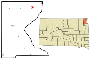
Florence is a town in northwestern Codington County, South Dakota, United States. It is part of the Watertown, South Dakota Micropolitan Statistical Area. The population was 337 at the 2020 census.

<span class="mw-page-title-main">Fairburn, South Dakota</span> Town in South Dakota, United States

Fairburn is a town in Custer County, South Dakota, United States. The population was 60 at the 2020 census.

<span class="mw-page-title-main">Ethan, South Dakota</span> Town in South Dakota, United States

Ethan is a town in Davison County, South Dakota, United States. It is part of the Mitchell, South Dakota Micropolitan Statistical Area. The population was 365 at the 2020 census. Ethan is located 10 miles south of Mitchell.

<span class="mw-page-title-main">Onaka, South Dakota</span> Town in South Dakota, United States

Onaka is a town in Faulk County, South Dakota, United States. The population was 13 at the 2020 census.

<span class="mw-page-title-main">Strandburg, South Dakota</span> Town in South Dakota, United States

Strandburg is a town in southern Grant County, South Dakota, United States. The population was 63 at the 2020 census. Its name is derived from the town's founder, the Swedish John Strandburg.

<span class="mw-page-title-main">Lake City, South Dakota</span> Town in South Dakota, United States

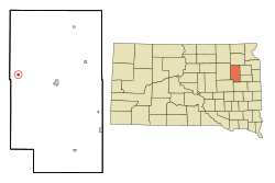
Lake City is a town in Marshall County, South Dakota, United States. The population was 45 at the 2020 census. Fort Sisseton Historic State Park, whose fort is listed on the National Register of Historic Places, is located nearby.

<span class="mw-page-title-main">Langford, South Dakota</span> Town in South Dakota, United States

Langford is a town in Marshall County, South Dakota, United States. The population was 283 at the 2020 census.

<span class="mw-page-title-main">Crooks, South Dakota</span> City in South Dakota, United States

Crooks is a city in Minnehaha County, South Dakota, United States and is a suburb of Sioux Falls. The population was 1,362 at the 2020 census. Crooks was named New Hope until 1904. The town's present name honors W. A. Crooks, a local politician.

<span class="mw-page-title-main">Peever, South Dakota</span> Town in South Dakota, United States

Peever is a town in Roberts County, South Dakota, United States. The population was 180 at the 2020 census.

<span class="mw-page-title-main">Rosholt, South Dakota</span> Town in South Dakota, United States

Rosholt is a town in Roberts County, South Dakota, United States. The population was 379 at the 2020 census.

<span class="mw-page-title-main">Tulare, South Dakota</span> Town in South Dakota, United States

Tulare is a town in Spink County, South Dakota, United States. The population was 211 at the 2020 census.

<span class="mw-page-title-main">New Witten, South Dakota</span> Town in South Dakota, United States

New Witten is a town in Tripp County, South Dakota, United States. The population was 54 at the 2020 census.

<span class="mw-page-title-main">Lowry, South Dakota</span> Town in South Dakota, United States

Lowry is a town in Walworth County, South Dakota, United States. The population was 10 at the 2020 census. The town is home to Lowry Pilgrim Community Church, Swan Creek Harness Shop, J & C Repair, Karst Service and a fire station. Lowry also has an abandoned school, and a post office, which closed to service in the early 1970s.

References

  1. "SD Towns" (PDF). South Dakota State Historical Society . Retrieved February 15, 2010.
  2. "ArcGIS REST Services Directory". United States Census Bureau. Retrieved October 15, 2022.
  3. 1 2 U.S. Geological Survey Geographic Names Information System: Raymond, South Dakota
  4. 1 2 "Census Population API". United States Census Bureau. Retrieved October 15, 2022.
  5. 1 2 "U.S. Census website". United States Census Bureau . Retrieved January 31, 2008.
  6. "U.S. Census Bureau: Raymond town, South Dakota". www.census.gov. United States Census Bureau. Retrieved April 16, 2022.
  7. "Clark County". Jim Forte Postal History. Retrieved March 26, 2015.
  8. 1 2 Chicago and North Western Railway Company (1908). A History of the Origin of the Place Names Connected with the Chicago & North Western and Chicago, St. Paul, Minneapolis & Omaha Railways. p. 117.
  9. "US Gazetteer files 2010". United States Census Bureau. Archived from the original on January 25, 2012. Retrieved June 21, 2012.
  10. "Census of Population and Housing". Census.gov. Retrieved June 4, 2015.
  11. "U.S. Census website". United States Census Bureau . Retrieved June 21, 2012.

Commons-logo.svg Media related to Raymond, South Dakota at Wikimedia Commons