
Black Giant is a 13,330-foot-elevation (4,060-meter) mountain summit located near the crest of the Sierra Nevada mountain range, in Fresno County of northern California, United States. Black Giant ranks as the 86th highest summit in California. It is situated in northern Kings Canyon National Park, 21 miles (34 km) west-southwest of the community of Big Pine, 3.6 miles (5.8 km) southwest of Mount Thompson, and 2.6 miles (4.2 km) south-southeast of Mount Fiske, which is the nearest higher neighbor. Topographic relief is significant as it rises 4,000 feet above LeConte Canyon in approximately two miles. Muir Pass is 1.5 miles (2.4 km) to the northwest, and the approach to this remote peak is made via the John Muir Trail.
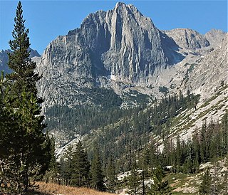
The Citadel is an 11,738-foot-elevation (3,578-meter) mountain summit located in the Sierra Nevada mountain range, in Fresno County of central California, United States. It is situated in northern Kings Canyon National Park, 20 miles (32 km) west-southwest of the community of Big Pine, and 2.4 miles (3.9 km) south of Langille Peak. Topographic relief is significant as it rises 3,400 feet above LeConte Canyon in approximately one mile. The long approach to this remote peak is made via the John Muir Trail. The Northeast Arête, also known as Edge of Time Arête, is considered one of the classic climbing routes in the Sierra Nevada.

Mount Gayley is a 13,510-foot-elevation mountain summit located one mile east of the crest of the Sierra Nevada mountain range in Inyo County, California, United States. It is situated in the Palisades area of the John Muir Wilderness, on land managed by Inyo National Forest. It is approximately 13 miles (21 km) west-southwest of the community of Big Pine, 0.67 miles (1.08 km) southwest of Temple Crag, and 0.5 miles (0.80 km) north-northeast of parent Mount Sill. Mount Gayley ranks as the 59th highest summit in California.

Mount Haeckel is a 13,424-foot (4,092 m) mountain summit located on the crest of the Sierra Nevada mountain range in northern California, United States. It is situated on the shared boundary of Kings Canyon National Park with John Muir Wilderness, and along the common border of Fresno County with Inyo County. It is 21.5 miles (34.6 km) west of the community of Big Pine, 1.27 miles (2.04 km) south-southeast of Mount Darwin, and one mile north-northeast of Mount Fiske, which is the nearest higher neighbor. Mount Haeckel ranks as the 71st highest summit in California.
Cloudripper is a 13,525-foot-elevation mountain summit located two miles east of the crest of the Sierra Nevada mountain range in Inyo County of northern California, United States. It is situated in the Palisades area of the John Muir Wilderness, on land managed by Inyo National Forest. It is approximately 14 miles (23 km) west of the community of Big Pine, 1.1 miles (1.8 km) north-northeast of Picture Puzzle, and 2.1 miles (3.4 km) south of parent Mount Agassiz. Cloudripper ranks as the 58th highest summit in California, and the highest point of the Inconsolable Range.
Hurd Peak is a 12,237-foot-elevation (3,730-meter) mountain summit located one mile east of the crest of the Sierra Nevada mountain range in Inyo County of northern California, United States. Surrounded by lakes, it is situated in the John Muir Wilderness, on land managed by Inyo National Forest. It is approximately 16 miles (26 km) west of the community of Big Pine, 2 miles (3.2 km) west of Picture Puzzle, and 1.23 miles (1.98 km) north of parent Mount Goode. Topographic relief is significant as the north aspect rises nearly 2,500 feet above South Lake in approximately one mile.

Red and White Mountain is a remote 12,816-foot-elevation mountain summit located on the crest of the Sierra Nevada mountain range in northern California, United States. It is situated in the John Muir Wilderness on the shared boundary of Sierra National Forest with Inyo National Forest, and along the common border of Fresno County with Mono County. It is eight miles northeast of Lake Thomas A Edison, and approximately 13 miles (21 km) southeast of the community of Mammoth Lakes. The nearest higher neighbor is Red Slate Mountain, 2 miles (3.2 km) to the north-northwest.

Crater Mountain is a 12,874-foot-elevation (3,924-meter) mountain summit located west of the crest of the Sierra Nevada mountain range, in Fresno County of northern California, United States. It is situated in eastern Kings Canyon National Park, 15.5 miles (24.9 km) northwest of the community of Independence, one mile immediately southwest of Pinchot Pass, and 1.3 miles (2.1 km) southeast of Mount Ickes, which is the nearest higher neighbor. Other nearby peaks include Mount Wynne, 1.5 miles (2.4 km) to the northeast, and Mount Cedric Wright, 2.2 miles (3.5 km) to the southeast. Crater Mountain ranks as the 186th highest summit in California. Topographic relief is significant as the west aspect rises 2,000 feet in less than one mile. The approach to this remote peak is made via the John Muir Trail which passes below the east aspect of the mountain. The first ascent of the summit was made July 19, 1922, by W. H. Ink, Meyers Butte, Frank Baxter, and Captain Wallace. This mountain has no crater as the name implies.
Colosseum Mountain is a 12,473-foot-elevation double summit mountain located on the crest of the Sierra Nevada mountain range in northern California. It is situated on the common border of Fresno County with Inyo County, as well as the shared boundary of John Muir Wilderness and Kings Canyon National Park. It is 12 miles (19 km) northwest of the community of Independence, 1.2 miles (1.9 km) east of Mount Cedric Wright, 2.6 miles (4.2 km) west of Sawmill Point, and 1.6 miles (2.6 km) south-southeast of Mount Perkins, the nearest higher neighbor. The lower east summit is 12,451-feet in elevation and marked as Colosseum Mountain on maps, but the 12,473-foot west summit is higher. Approximately 1,000 feet distance separate the two summits. The John Muir Trail passes to the west of this peak, providing an approach to the mountain. The first ascent of the summit was made August 5, 1922, by Chester Versteeg, a prominent Sierra Club member, via the southwest face.
Center Peak is a 12,760-foot-elevation (3,890-meter) mountain summit located one mile west of the crest of the Sierra Nevada mountain range, in the northeast corner of Tulare County in northern California. It is situated in eastern Kings Canyon National Park, 11 miles (18 km) southwest of the community of Independence, 1.8 miles (2.9 km) south of University Peak, and two miles north of Forester Pass. Topographic relief is significant as the north aspect rises 2,230 feet above Bubbs Creek in one mile. The John Muir Trail which traverses below the west slope of this remote peak provides an approach.
Mount Hilgard is a 13,361-foot-elevation (4,072 meter) mountain summit located west of the crest of the Sierra Nevada mountain range in Fresno County of northern California, United States. It is situated in the John Muir Wilderness on land managed by Sierra National Forest, approximately eight miles east-southeast of Lake Thomas A Edison, and immediately above the west end of Lake Italy. The nearest higher neighbor is Mount Gabb, 1.75 miles (2.82 km) to the northeast, and Recess Peak is 2.2 miles (3.5 km) to the northwest. The John Muir Trail follows Bear Creek to the west of this remote peak, providing an approach. Mt. Hilgard ranks as the 82nd highest summit in California.

Thor Peak is a 12,306-foot-elevation (3,751-meter) mountain summit located east of the crest of the Sierra Nevada mountain range in Inyo County, California. It is situated in the John Muir Wilderness on land managed by Inyo National Forest. It is 12.5 miles (20.1 km) west of the community of Lone Pine, and 1.5 miles (2.4 km) east of Mount Whitney. Topographic relief is significant as it rises 3,937 feet above Whitney Portal in 1.5 mile. Hikers on the Mount Whitney Trail pass below the impressive south face of the peak.

Mount Tinemaha is a 12,520-foot-elevation (3,820-meter) mountain summit located east of the crest of the Sierra Nevada mountain range, in Inyo County of northern California. It is situated on the eastern boundary of the John Muir Wilderness, on land managed by Inyo National Forest. It is 1.3 mile southeast of Tinemaha Lake, and 1.8 mile northeast of parent Split Mountain. Topographic relief is significant as the east aspect rises 5,900 feet above Owens Valley in two miles.

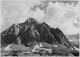
Mount Powell is a 13,364-foot-elevation mountain summit located on the crest of the Sierra Nevada mountain range in California, United States. It is situated on the shared boundary of Kings Canyon National Park with John Muir Wilderness, and along the common border of Fresno County with Inyo County. It is also 19 miles (31 km) west of the community of Big Pine, and 1.17 miles (1.88 km) west of Mount Thompson, which is the nearest higher neighbor. Mount Powell ranks as the 81st highest peak in California, and the 10th highest of the Evolution Region of the Sierra Nevada. The west summit is unofficially known as "Point John." Two other peaks on the mountain are informally called "Point Wesley" (13,356 ft) in the middle, and "Point Powell" (13,360+ ft) one-half mile to the east.

Mount Starr, elevation 12,835 feet (3,912 m), is a mountain summit located on the crest of the Sierra Nevada mountain range in northern California, United States. It is situated in the John Muir Wilderness on the common boundary shared by Sierra National Forest with Inyo National Forest, and along the common border of Fresno County with Inyo County. It is bound on the east by Little Lakes Valley, and is 0.8 mile northeast of Mono Pass. Topographic relief is significant as the summit rises 2,300 feet above Little Lakes Valley in approximately one-half mile (0.80 km). Neighbors include Mount Abbot, three miles to the south-southwest, Mount Morgan, 2.5 miles to the southeast, and Pointless Peak is 2.5 miles to the north.

Mount Crocker is a remote 12,458-foot-elevation mountain summit located on the crest of the Sierra Nevada mountain range in northern California, United States. It is situated in the John Muir Wilderness, on the boundary shared by Sierra National Forest with Inyo National Forest, and along the common border of Fresno County with Mono County. Crocker ranks as the 291st-highest summit in California. Topographic relief is significant as the north aspect rises 2,500 feet above McGee Creek in approximately one mile. It is nine miles northeast of Lake Thomas A Edison, and approximately 15 miles (24 km) southeast of the community of Mammoth Lakes.

Mount Stanford is a 12,838-foot-elevation (3,913 meter) mountain summit located on the crest of the Sierra Nevada mountain range in northern California, United States. It is situated in the John Muir Wilderness, on the boundary shared by Sierra National Forest with Inyo National Forest, and along the common border of Fresno County with Mono County. It is 10 miles northeast of Lake Thomas A Edison, and approximately 15 miles (24 km) southeast of the community of Mammoth Lakes. Topographic relief is significant as the north aspect rises 3,200 feet above McGee Creek in approximately 1.75 mile. There is another Mount Stanford in the Sierra Nevada which is named for Stanford University.

Mount Izaak Walton is a 12,077-foot-elevation (3,681 meter) mountain summit located in the Sierra Nevada mountain range in Fresno County of northern California, United States. It is situated in the John Muir Wilderness, on land managed by Sierra National Forest. Mount Izaak Walton ranks as the 404th-highest summit in California. Topographic relief is significant as the northwest aspect rises 1,800 feet above Izaak Walton Lake in approximately one mile. It is six miles northeast of Lake Thomas A Edison, and approximately 14 miles (23 km) south-southeast of the community of Mammoth Lakes. The peak is set on Silver Divide, so precipitation runoff from the north side of this mountain drains into Fish Creek which is a tributary of the San Joaquin River, and from the south slope to Mono Creek, also a tributary of the San Joaquin.

Pilot Knob is a 12,245-foot-elevation (3,732 meter) mountain summit located in Fresno County in the Sierra Nevada mountain range in northern California, United States. It is situated at the intersection of Piute Canyon and French Canyon, in the John Muir Wilderness, on land managed by Sierra National Forest. It is set 2.5 miles (4.0 km) south of Merriam Peak and three miles north of the Matthes Glaciers. Pilot Knob is the 360th-highest peak in California, and topographic relief is significant as the west aspect rises 2,800 feet above Hutchinson Meadow in approximately one mile. This mountain was likely named by the USGS during the 1907–09 survey for the Mt. Goddard Quadrangle, and the toponym has been officially adopted by the U.S. Board on Geographic Names.
Mount Julius Caesar is a 13,213-foot-elevation mountain summit located on the crest of the Sierra Nevada mountain range in northern California, United States. It is situated in the John Muir Wilderness on the boundary that Sierra National Forest shares with Inyo National Forest, and along the common border shared by Fresno County with Inyo County. It is one mile southwest of line parent Bear Creek Spire, and 22 miles (35 km) west of the community of Bishop. Italy Pass is one-half mile immediately south of the summit, and Granite Park lies to the southeast. Mount Julius Caesar ranks as the 106th-highest summit in California. Topographic relief is significant as the summit rises 2,000 feet above Lake Italy in 0.7 miles (1.1 km).


