Red Line (Calgary)

Last updated
Red Line
Red Line Icon.svg
S200 CTrain leaving City Hall Station.jpg
A Red Line train at City Hall station
Overview
StatusOperational
Owner Calgary Transit
Locale Calgary, Alberta, Canada
Termini
Stations27
Website Calgary Transit
Service
Type Light rail
System CTrain
Route number201
Operator(s)Calgary Transit
History
OpenedMay 25, 1981 [1]
Technical
Line length32.2 km (20.0 mi)
Number of tracks2
CharacterAt-grade
Track gauge 1,435 mm (4 ft 8+12 in) standard gauge
Electrification Overhead lines, 600 V DC [2]
Route diagram

Contents

BSicon uKBHFa.svg
Tuscany
BSicon RP4e.svg
BSicon uSKRZ-G4o.svg
BSicon RP4w.svg
BSicon uBHF.svg
Crowfoot
BSicon uBHF.svg
Dalhousie
BSicon uBHF.svg
Brentwood
BSicon uBHF.svg
University
BSicon uTUNNEL1.svg
BSicon uBHF.svg
Banff Trail
BSicon uTUNNEL1.svg
19th Street & Alberta Highway 1.svg Hwy 1 16 Ave N tunnel
BSicon uBHF.svg
Lions Park
BSicon uBHF.svg
Jubilee
BSicon uBHF.svg
Sunnyside
BSicon dWASSERq.svg
BSicon uhKRZWae.svg
BSicon dWASSERq.svg
BSicon uCONTg.svg
BSicon uSTR.svg
  Blue Line  
BSicon uKRWl.svg
BSicon uKRW+r.svg
BSicon GRZq-.svg
BSicon uSTR.svg
Northwest Line
Free fare zone
BSicon uBHF(R)f.svg
8 Street SW
BSicon uBHF(L)g.svg
7 Street SW
BSicon uBHF(R)f.svg
6 Street SW
BSicon uBHF(L)g.svg
4 Street SW
BSicon uBHF(R)f.svg
3 Street SW
BSicon uBHF(L)g.svg
1 Street SW
BSicon uBHF(R)f.svg
Centre Street
BSicon uBHF.svg
City Hall
BSicon uKRWgl.svg
BSicon -GRZq.svg
BSicon uSTR.svg
BSicon uKRW+r.svg
Free fare zone
South Line
BSicon uTUNNEL1.svg
BSicon uCONTf.svg
  Blue Line  
BSicon uBHF.svg
Victoria Park/Stampede
BSicon dWASSERq.svg
BSicon uhKRZWae.svg
BSicon dWASSERq.svg
BSicon uBHF.svg
Erlton/Stampede
BSicon uTUNNEL1.svg
BSicon uBHF.svg
39 Avenue
BSicon uTUNNEL1.svg
39 Ave SE tunnel
BSicon uBHF.svg
Chinook
BSicon RP4e.svg
BSicon uSKRZ-G4u.svg
BSicon RP4w.svg
BSicon uBHF.svg
Heritage
BSicon uABZgl+l.svg
BSicon uKDSTeq.svg
Haysboro Yard
BSicon uBHF.svg
Southland
BSicon uBHF.svg
Anderson
BSicon uABZgl+l.svg
BSicon uKDSTeq.svg
Anderson Yard
BSicon uBHF.svg
Canyon Meadows
BSicon uBHF.svg
Fish Creek–Lacombe
BSicon uBHF.svg
Shawnessy
BSicon uKBHFe.svg
Somerset–Bridlewood

The Red Line, also known as Route 201, is a light rail transit (LRT) line in Calgary, Alberta, Canada. Partnered with the Blue Line, and future Green Line it makes up Calgary's CTrain network. Following its initial approval in 1976, the Red Line opened in 1981, running from Anderson station in the southeast into downtown. The Red Line has gone through a series of expansions, which bring it to its current design. The Red Line services the northwest quadrant and south end of the city beginning at Tuscany station, runs through the downtown core on 7th Avenue, then proceeds southbound where it terminates at Somerset–Bridlewood station. The section of track running along 7th Avenue is shared with the Blue Line. Future expansion of the Red Line includes rerouting the downtown section below 8th Avenue, which would allow the operation of five-car trains, further increasing capacity.

History

Origin

The concept of a light rail transit system (LRT) was approved in 1976 by the City of Calgary, with the first 12.9-kilometre (8.0 mi) section running from Anderson Road in the southwest, northbound, and into downtown, opening in 1981. Originally planned for 40,000 passengers per day, this initial section quickly achieved its designed ridership and is now part of the Red Line. Based on the success of the Anderson-downtown section, the city approved a second route which would head northwest towards the University of Calgary and the Southern Alberta Institute of Technology. Opposition to the routing through the neighborhood of Sunnyside resulted in a switch of priority to the northeast, in what would become the Blue Line. The first 9.8-kilometre (6.1 mi) section of the Blue Line opened in 1985. Both lines share a right-of-way through the downtown core. The decision to proceed with the original CTrain expansion northwest (in what would be part of the current Red Line) overcame opposition following Calgary being awarded the 1988 Winter Olympics. The city wanted the CTrain to access McMahon Stadium at the University of Calgary, which served as a venue for the games. [1]

Northwest expansion

In 1987 the third expansion of the CTrain opened adding an additional 5.8 kilometres (3.6 mi) of line into service towards the northwest, and in 1990 a second northwest expansion of 0.8 kilometres (0.50 mi) to the Brentwood station. [1] In 2000 a reallocation of 5¢ per-litre collected through the provincial gasoline tax helped fund the northwest expansion of the Red Line to Dalhousie station in 2003. [1] This was followed by another extension to Crowfoot station in 2008, and finally to Tuscany station in 2014. [3]

Southern expansion

The fuel tax reallocation allowed the Red Line to expand to the south to the Fish Creek–Lacombe station in 2001, with a further southern expansion to Somerset–Bridlewood station in 2004. [1]

Capacity upgrade

Up until the completion of the Fish Creek–Lacombe station, all platforms for the CTrain were originally designed to service three-car trains, although there had been enough space allotted to allow four car trains. Beginning in 2007 construction on station platforms began to expand the entire network to allow four-car trains, with the project being completed in 2017 for CA$300 million. [4] In 2015 Calgary Transit began running four-car trains on the Red Line. The increase from three-car trains realized an additional capacity of 200 passengers per trip. [5]

Stations and route

Diagram of the CTrain network, showing the Red Line. Calgary Rapid Transit Network Map, Red Line Highlighted.png
Diagram of the CTrain network, showing the Red Line.

The Red Line begins in the northwest at Tuscany station, running southeast towards Downtown Calgary in the median of Crowchild Trail serving residential neighborhoods. The last station along Crowchild is University station, which serves the University of Calgary. The Red Line then travels underground below 24th Avenue Northwest, and returns above ground where it stops at Banff Trail station, which serves McMahon Stadium. The line continues southeast until it returns underground briefly to pass underneath 16th Avenue North/Trans-Canada Highway, returning to surface at Lions Park station. It then continues eastbound, servicing the Southern Alberta Institute of Technology, the Alberta University of the Arts, and the Jubilee Auditorium at SAIT/AUArts/Jubilee station. Continuing southbound the Red Line serves the neighbourhood of Sunnyside before crossing the Bow River into Downtown Calgary. The downtown section of the Red Line is shared with the Blue Line, beginning at 8 Street Southwest station, across 7th Avenue, and diverging after City Hall station, where the Red Line continues south.

After leaving downtown the Red Line returns underground through the neighborhood of Victoria Park, returning to run parallel to Macleod Trail at grade level. Victoria Park/Stampede station serves the Scotiabank Saddledome and the northern grounds of the Calgary Stampede, while Erlton/Stampede station serves the southern grounds. After Erlton the train returns underground to navigate Macleod Trail, a cemetery, and residential neighborhood, surfacing to reach the 39 Avenue station. It passes briefly underground below 42nd Avenue Southeast, and continues at grade level running adjacent to the Canadian Pacific Railway, crossing streets either via bridge or through controlled crossings, until it reaches its terminus at Somerset–Bridlewood station.

Key
Terminus
Southbound only
Northwest-bound only
StationOpenedTransfersNotes
Tuscany2014
Crowfoot 2009
Dalhousie 2003
Brentwood 1990  MO   MAX Orange
University 1987
Banff Trail 1987
Lions Park 1987  MO  Exchange to North Hill
SAIT/AUArts/Jubilee 1987  MO  
Sunnyside 1987
8 Street Southwest1981  B   Blue Free fare zone
7 Street Southwest1981  B  Free fare zone
6 Street Southwest1981  B  Free fare zone
4 Street Southwest1981  B  Free fare zone
3 Street Southwest1981  B  Free fare zone
1 Street Southwest1981  B  Free fare zone
Centre Street1981  B  
300 Airport
  MY   MAX Yellow
  MP   MAX Purple
Free fare zone
City Hall 1981  B  Free fare zone
Victoria Park/Stampede 1981
Erlton/Stampede 1981
39 Avenue 1981
Chinook 1981
Heritage 1981  MT   MAX Teal
Southland 1981
Anderson 1981
Canyon Meadows 2001
Fish Creek–Lacombe 2001
Shawnessy 2004
Somerset–Bridlewood2004

Future expansion

Expansion of the Red Line is expected to include a rerouting of the downtown 7th Avenue section which is currently shared with the Blue Line to run underground below 8th Avenue. These stations would be built longer than the existing four-car platforms, and would be able to accommodate five-car trains. Extensions of the existing four-car platforms outside of the downtown core would be required, however there is enough land available at existing stations. There is not enough space at the downtown 7th Avenue stations to accommodate five-car trains. [5]

It has also been proposed to add new stations on the existing line. Stations would be added between Brentwood and Dalhousie stations at Northland Drive, between 39 Avenue and Chinook stations, and between Chinook and Heritage stations. [6]

Calgary Transit have planned an extension of the southern leg of the Red Line through two new stations at Silverado and 210 Avenue S. [7] [8] As of August 2022, no funding or schedules have been advanced for the proposed southern extension. [9]

See also

Related Research Articles

<span class="mw-page-title-main">Calgary Transit</span> Public transit service in Calgary, Alberta

Calgary Transit is the public transit agency which is owned and operated by the city of Calgary, Alberta, Canada. In 2019, an estimated 106.5 million passengers boarded approximately 1,155 Calgary Transit vehicles. It operates light metro (LRT), urban tramway, bus rapid transit (BRT), para-transit, and regular bus services. In 2022, the system had a ridership of 103,306,500, or about 389,000 per weekday as of the fourth quarter of 2022.

<span class="mw-page-title-main">CTrain</span> Light rail transit system in Calgary, Alberta

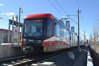
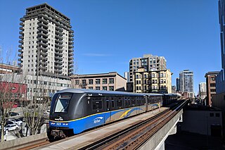
CTrain is a light rail rapid transit system in Calgary, Alberta, Canada. Much of the system functions as a high-capacity light metro, while in the downtown free-fare zone trains transitions into a tram with a dedicated right-of-way. The CTrain began operation on May 25, 1981 and has expanded as the city has increased in population. The system is operated by Calgary Transit, as part of the Calgary municipal government's transportation department. In 2022, the system had a ridership of 61,889,500, or about 228,800 per weekday as of the fourth quarter of 2022, making it one of the busiest light rail transit systems in North America. Approximately 45% of workers in Downtown Calgary take the CTrain to work.

<span class="mw-page-title-main">Chinook station</span> Light rail station in Calgary, Alberta, Canada

Chinook station is a CTrain light rail station in Manchester, Calgary, Alberta. The station opened on May 25, 1981, as part of the original South line on the Red Line.

<span class="mw-page-title-main">Banff Trail station</span> Light rail station in Calgary, Alberta, Canada

Banff Trail station is a CTrain light rail station in Banff Trail, Calgary, Alberta, Canada. It serves the Northwest Line and opened on September 7, 1987, as part of the original line. It is located on the exclusive LRT right of way on the east side of Banff Trail NW, 4.1 km northwest of the 7 Avenue & 9 Street SW interlocking. The station consists of two side-loading platforms with grade-level access from a pedestrian crossing of the tracks at the northern end of the station.

<span class="mw-page-title-main">Brentwood station (Calgary)</span> Light rail station in Calgary, Alberta, Canada

Brentwood Station is a Calgary C-Train light rail station on the Red Line, between University Station southbound and Dalhousie Station northbound. The station is located in the middle of Crowchild Trail, wedged between the communities of Brentwood to the north, and Varsity to the south. The station acts as a transfer point, connecting with the bus routes of MAX Orange, North Pointe, Foothills Medical Centre, Dalhousie, Chinook, Greenwood/Brentwood, Market Mall, Downtown West, Nolan Hill, and Valley Ridge.

<span class="mw-page-title-main">Lions Park station</span> Light rail station in Calgary, Alberta, Canada

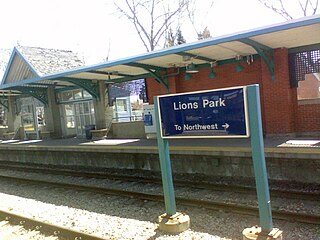
Lions Park station is a Calgary C-Train light rail station in Hounsfield Heights-Briar Hill, Calgary, Alberta, Canada. Opened on September 7, 1987 as part of the original Northwest Line. It is located on the exclusive LRT right of way on the south side of 14 Avenue NW, just east of 19 Street NW. Two side-loading platforms with ramp access from grade level as well as pedestrian crossings are located at both ends of the station. The station is located adjacent to the Mall Entrance 5 of the North Hill Centre shopping mall, and is less than 1 kilometre away from the campus of SAIT.

<span class="mw-page-title-main">10 Street Southwest station</span> Light rail station in Calgary, Alberta, Canada

10 Street Southwest station was a CTrain light rail station in Calgary, Alberta, Canada. It was the western terminus of Route 202. It was closed and replaced with Downtown West–Kerby station.

<span class="mw-page-title-main">Victoria Park/Stampede station</span> Light rail station in Calgary, Alberta, Canada

Victoria Park/Stampede station is CTrain light rail station in Beltline, Calgary, Alberta, Canada. Adjacent to the Stampede Park, the site of the Calgary Stampede, opened on May 25, 1981, as part of the original line.

<span class="mw-page-title-main">39 Avenue station (Calgary)</span> Light rail station in Calgary, Alberta, Canada

39 Avenue Station is a Calgary C-Train LRT station on the south leg of the Red Line, between Erlton-Stampede Station southbound and Chinook Station northbound. The station is located inside of the community of Manchester, an industrial community in Calgary, Alberta. 39 Avenue Station opened on May 25, 1981, as part of the original South line. The station is located on the exclusive LRT right of way 3.4 kilometres south of the City Hall Interlocking, at 39 Avenue SE, just east of Macleod Trail.

<span class="mw-page-title-main">Shawnessy station</span> Light rail station in Calgary, Alberta, Canada

Shawnessy is a CTrain light rail station in Shawnessy, Calgary, Alberta. It serves the South Red Line. It is located on the exclusive LRT right of way, 16 km south of the City Hall interlocking.

<span class="mw-page-title-main">Somerset–Bridlewood station</span> Light rail station in Calgary, Alberta, Canada

Somerset–Bridlewood station is a CTrain light rail station in Somerset, Calgary, Alberta, Canada. It is the current southern terminus of the South Line. The station is one of two that opened on June 28, 2004 as part of the South LRT Extension Phase II. The station is located on the exclusive LRT right of way, 16.9 km south of the City Hall interlocking along Shawville Gate. 913 parking spaces are included in the park-and-ride facility at the station.

Crowchild Trail is a major expressway in western Calgary, Alberta. The segment from the 12 Mile Coulee Road at the edge of the city to 16 Avenue NW is designated as Highway 1A by Alberta Transportation. The road is a critical north-south link in West Calgary for both downtown bound traffic and travel between the two quadrants of the city it passes through. Although planned to be one single freeway from Glenmore Trail to the city limits, the route is currently divided by a section of slow moving arterial road with four signalized intersections between 24 Avenue and Memorial Drive. This causes the freeway in the northwest to separated from the freeway south of the Bow River. Filling the gap and making the whole route a minimum six lane freeway is currently planned for construction beyond 2027.

The city of Calgary, Alberta, has a large transportation network that encompasses a variety of road, rail, air, public transit, and pedestrian infrastructure. Calgary is also a major Canadian transportation centre and a central cargo hub for freight in and out of north-western North America. The city sits at the junction between the "Canamex" highway system and the Trans-Canada Highway.

<span class="mw-page-title-main">Light rail in North America</span> Mode of public transit

Light rail is a commonly used mode of public transit in North America. The term light rail was coined in 1972 by the Urban Mass Transportation Administration to describe new streetcar transformations which were taking place in Europe and the United States. The Germans used the term Stadtbahn, which is the predecessor to North American light rail, to describe the concept, and many in UMTA wanted to adopt the direct translation, which is city rail. However, in its reports, UMTA finally adopted the term light rail instead.

<span class="mw-page-title-main">Tuscany station</span> Light rail station in Calgary, Alberta, Canada

Tuscany station is a CTrain light rail station in Tuscany and Rocky Ridge, Calgary, Alberta, Canada. It is the northern terminus of the Northwest Line, and opened as part of the route's the 2 km extension on August 23, 2014. Originally referred to in planning documents as Tuscany/Rocky Ridge station, Calgary Transit simplified the name on the recommendation of the Community Consultation Committee.

<span class="mw-page-title-main">Saddletowne station</span> Light rail station in Calgary, Alberta, Canada


Saddletowne station is a CTrain light rail station in on the Northeast Line in Saddle Ridge Calgary, Alberta. Opened on August 27, 2012 as part of a 2.9-km extension.

<span class="mw-page-title-main">Blue Line (Calgary)</span> Light rail line in Calgary, Alberta

The Blue Line, also known as Route 202, is a light rail transit (LRT) line in Calgary, Alberta, Canada. Partnered with the Red Line, and future Green Line it makes up Calgary's CTrain network. Following its initial approval in 1976, the Red Line opened in 1981, with the first trains running on what is now the Blue Line in 1985.

The Green Line is a light rail (LRT) line under construction in Calgary, Alberta, Canada. The line will run between Calgary’s north-central and southeastern boundaries, connecting with the Red Line and Blue Line in the city’s downtown. The Green Line is the largest public infrastructure project in Calgary's history and will be the first rail line in the city to operate low-floor trains. When completed, the Green Line will comprise 29 stations spanning 46 kilometres (29 mi). This will bring the total number of CTrain stations in Calgary to 74.

<span class="mw-page-title-main">Urban rail transit in Canada</span> List of Canadian passenger rail systems confined to urban areas

Urban rail transit in Canada encompasses a broad range of rail mass transit systems, including commuter rail, rapid transit, light rail, and streetcar systems.

References

  1. 1 2 3 4 5 Hubbel, John; Colquhoun, Dave (12 April 2006). "Light Rail Transit in Calgary The First 25 Years" (PDF). Retrieved 12 March 2018.{{cite journal}}: Cite journal requires |journal= (help)
  2. "SD160 Light Rail Vehicle: Calgary, Canada" (PDF). Siemens Transportation Systems, Inc. 2007. Archived from the original (PDF) on October 26, 2010. Retrieved January 23, 2011. Catenary supply voltage: 600 Vdc
  3. Markusoff, Jason (24 August 2014). "Opening of Tuscany LRT station marks end of rapid rail expansion". www.calgaryherald.com. Retrieved 12 March 2018.
  4. Markusoff, Jason (8 May 2014). "Four-car LRT project's price tag hits $300M". Calgary Herald. Retrieved 12 March 2018.
  5. 1 2 Gilligan, Melissa (1 May 2017). "Calgary Transit launches 4-car CTrain service on Blue Line LRT". Global News. Retrieved 12 March 2018.
  6. "New stops on Calgary's Red Line LRT | Watch News Videos Online".
  7. Calgary LRT Network Plan (PDF) (Report). Retrieved 21 May 2019.
  8. Smith, Kevin (October 29, 2012). "Canada's light rail renaissance". International Railway Journal. Retrieved 21 May 2019.
  9. "Future extensions of the Red Line". Calgary Transit. Retrieved 21 May 2019.