
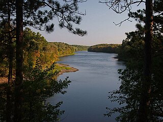
The Mississippi River is the primary river, and second-longest river, of the largest drainage basin in the United States. From its traditional source of Lake Itasca in northern Minnesota, it flows generally south for 2,340 miles (3,766 km) to the Mississippi River Delta in the Gulf of Mexico. With its many tributaries, the Mississippi's watershed drains all or parts of 32 U.S. states and two Canadian provinces between the Rocky and Appalachian mountains. The main stem is entirely within the United States; the total drainage basin is 1,151,000 sq mi (2,980,000 km2), of which only about one percent is in Canada. The Mississippi ranks as the thirteenth-largest river by discharge in the world. The river either borders or passes through the states of Minnesota, Wisconsin, Iowa, Illinois, Missouri, Kentucky, Tennessee, Arkansas, Mississippi, and Louisiana.

Interstate 94 (I-94) is an east–west Interstate Highway connecting the Great Lakes and northern Great Plains regions of the United States. Its western terminus is just east of Billings, Montana, at a junction with I-90; its eastern terminus is in Port Huron, Michigan, where it meets with I-69 and crosses the Blue Water Bridge into Sarnia, Ontario, Canada, where the route becomes Ontario Highway 402. It thus lies along the primary overland route from Seattle to Toronto and is the only east–west Interstate Highway to have a direct connection to Canada.

Goodhue County is a county in the U.S. state of Minnesota. As of the 2020 census, the population was 47,582. Its county seat is Red Wing. Nearly all of Prairie Island Indian Community is within the county.
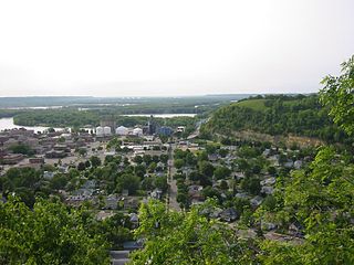
Red Wing is a city and the county seat of Goodhue County, Minnesota, United States, along the upper Mississippi River. The population was 16,547 at the 2020 census.

Hastings is a city mostly in Dakota County, Minnesota, of which it is the county seat, with a portion in Washington County, Minnesota, United States. It is near the confluence of the Mississippi, Vermillion, and St. Croix Rivers. The population was 22,154 at the 2020 census. It is named for the first elected governor of Minnesota, Henry Hastings Sibley.

The Cannon River a tributary of the Mississippi River flows 112 miles (180 km) from Shields Lake near Shieldsville to Red Wing in the U.S. state of Minnesota, where it joins the Mississippi River. It drains a watershed approximately 1460 square miles (3,780 km²) in size. The river flows through the counties of Le Sueur, Rice, Dakota, and Goodhue.
Crow Wing State Park is a state park of Minnesota, United States, at the confluence of the Mississippi and Crow Wing Rivers. The park interprets the site of Old Crow Wing, one of the most populous towns in Minnesota in the 1850s and 1860s. The entire park was added to the National Register of Historic Places in 1970. A section of the Red River Trails that passed through Old Crow Wing is also separately listed on the National Register.
Southeast Minnesota comprises the corner of the U.S. state of Minnesota south of the Twin Cities metropolitan area extending east, and part of the multi-state area known as the Driftless Area. Rochester is the largest city in the area; other major cities include Winona, Owatonna, Faribault, Northfield, Austin, and Red Wing.

The I-35W Mississippi River bridge was an eight-lane, steel truss arch bridge that carried Interstate 35W across the Mississippi River one-half mile downstream from the Saint Anthony Falls in Minneapolis, Minnesota, United States. The bridge opened in 1967 and was Minnesota's third busiest, carrying 140,000 vehicles daily. It experienced a catastrophic failure during the evening rush hour on August 1, 2007, killing 13 people and injuring 145. The NTSB cited a design flaw as the likely cause of the collapse, noting that an excessively thin gusset plate ripped along a line of rivets, and that additional weight on the bridge at the time contributed to the catastrophic failure.
Highway 25 Bridge is a concrete girder bridge that spans the Mississippi River between Monticello, Minnesota and Big Lake, Minnesota. It was built in 1988 by the Minnesota Department of Transportation and was designed by VanDoren Hazard Stallings.

DeSoto Bridge was a trussed deck-arch bridge that spanned the Mississippi River in St. Cloud, Minnesota. It was built in 1958 by the Minnesota Department of Transportation. The bridge was painted black, which is typical for railroad bridges but unusual for a highway bridge. The river banks on either side are relatively high, so the bridge required deep trusses which arched over the river.

Minnesota State Highway 43 is a highway in southeast Minnesota, which runs from its intersection with State Highway 44 in Mabel and continues north to its northern terminus at the Wisconsin state line at Winona, where it becomes Wisconsin Highway 54 upon crossing the Mississippi River.

The Zumbrota Covered Bridge is the last remaining historic covered bridge in the U.S. state of Minnesota. It has been restored and is located in Covered Bridge Park in Zumbrota, Minnesota.

Old Crow Wing is a ghost town in Fort Ripley Township, Crow Wing County, Minnesota, United States, at the confluence of the Mississippi and Crow Wing rivers. Long occupied by the Ojibwe people, for over a century it was also the northernmost European-American settlement on the Mississippi.

The I-35W Saint Anthony Falls Bridge crosses the Mississippi River one-half mile downstream from the Saint Anthony Falls in Minneapolis, Minnesota in the U.S., carrying north–south traffic on Interstate Highway 35W. The ten-lane bridge replaced the I-35W Mississippi River bridge, which collapsed on August 1, 2007. It was planned and is maintained by the Minnesota Department of Transportation (MnDOT). The planning, design, and construction processes were completed more quickly than normal because Interstate 35W is a critical artery for commuters and truck freight. The bridge opened September 18, 2008, well ahead of the original goal of December 24.

Barn Bluff is a bluff along the Mississippi River in Red Wing, Minnesota, United States. The bluff is considered sacred by the Dakota people because it is the site of many burial mounds. During the 19th century, the bluff functioned as a visual reference for explorers and travelers and later served as a limestone quarry.

U.S. Route 63 is a highway in southeastern Minnesota that runs from the Minnesota-Iowa border south of Spring Valley to the Mississippi River at Red Wing. It connects the cities of Spring Valley, Stewartville, Rochester, and Lake City.

U.S. Highway 61 (US 61) is a U.S. Highway in southeast and east-central Minnesota, which runs from the Mississippi River Bridge at La Crescent and continues north to its northern terminus at its junction with Interstate 35 (I-35) at the city of Wyoming.
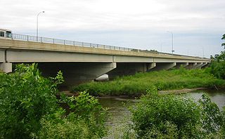
The Lloyd Spriggle Memorial Bridge is a steel girder bridge with a concrete deck, crossing the Wisconsin Channel of the Mississippi River, which is the secondary channel at this point. The bridge carries U.S. Route 63 (US 63), connecting to the Eisenhower Bridge, which crosses the Minnesota Channel of the Mississippi River at Red Wing, Minnesota. The bridge was named for Lloyd Spriggle, a longtime local leader who worked for environmental protection, including protections of local lakes, rivers, and streams.

