Redditch Town Hall

Last updated

Redditch Town Hall
Redditch Town Hall - geograph.org.uk - 2949017.jpg
The building in 2012
LocationWalter Stranz Square, Redditch
Coordinates 52°18′18″N1°56′19″W / 52.3051°N 1.9386°W / 52.3051; -1.9386
Built1982
ArchitectCassidy & Ashton Partners and Ove Arup & Partners
Architectural style(s) Modern style
Worcestershire UK location map.svg
Red pog.svg
Shown in Worcestershire

Redditch Town Hall is a municipal building in Walter Stranz Square in Redditch, a town in Worcestershire, in England. It is the headquarters of Redditch Borough Council.

History

After significant population growth, largely associated with the needle and fishing tackle industries, a local board of health was formed in the area in 1858. [1] After the local board of health was succeeded by Redditch Urban District Council in 1894, [2] the new council adopted the old police station and magistrates' court in Evesham Street as its offices. [3] The council later acquired a Victorian style house on the corner of Mount Pleasant and Salop Street: that building became known as The Council House although, after the council left, it was rebuilt and became known as Stoneleigh House. [4]

The Council House in Mount Pleasant continued to serve as the headquarters of the urban district council for much of the 20th century and remained a meeting place for the enlarged Redditch Borough Council which was formed in 1974. [5] However, in the late 1970s, with the increasing responsibilities of the borough council, council leaders decided to commission a more substantial civic complex. The site they selected, on the southwest side of Alcester Street, was occupied by town's fire station. [6] [7]

The new building was designed by Cassidy & Ashton Partners in partnership with Ove Arup & Partners, built in red brick with metal roofs and was completed in 1982. The design involved an asymmetrical main frontage erected around a courtyard facing onto Alcester Street which featured fountains and an octagonal kiosk with a pyramid-shaped roof. [6] Internally, the principal room was the council chamber which was established in a single storey polygonal structure in the south east corner of the complex. The architectural historian, Nikolaus Pevsner, seemed unimpressed with some aspects of the design: he said that "the building outstays its welcome by extending…along the southwest of Alcester Street." [8]

The town hall was the venue, in October 1984, for the annual Aneurin Bevan Memorial Lecture during which the Deputy Leader of the Labour Party, Roy Hattersley, spoke about reducing unemployment and repatriating capital back to the UK. [9] [10]

By 2020, much of the building's floorspace was disused, leading to calls for a major renovation project. Civic leaders announced that the building would be extended, with a new entrance and reception area added, and it was confirmed that the town library, jobcentre and Citizens' Advice Bureau would all relocate to the building. [11] [12] It was also decided that the west wing would be converted to accommodate a National Health Service clinic, while the council chamber would move to the second floor. [13] [14] The first stage of the works, relating to the new clinic, was completed in October 2023, [15] while construction work to implement the second stage of project, relating to the relocation of the council chamber, commenced on site in April 2024. [16]

Related Research Articles

<span class="mw-page-title-main">Worcestershire</span> County of England

Worcestershire is a ceremonial county in the West Midlands of England. It is bordered by Shropshire, Staffordshire, and the West Midlands county to the north, Warwickshire to the east, Gloucestershire to the south, and Herefordshire to the west. The city of Worcester is the largest settlement and the county town.

<span class="mw-page-title-main">Kidderminster</span> Human settlement in England

Kidderminster is a market town and civil parish in Worcestershire, England, 20 miles (32 km) south-west of Birmingham and 12 miles (19 km) north of Worcester. Located north of the River Stour and east of the River Severn, in the 2021 census, it had a population of 57,400. The town is twinned with Husum, Germany.

<span class="mw-page-title-main">Alcester</span> Market town and civil parish in Warwickshire, England

Alcester is a market town and civil parish in the Stratford-on-Avon District in Warwickshire, England. It is 8 mi (13 km) west of Stratford-upon-Avon, and 7 miles south of Redditch. The town dates back to the times of Roman Britain and is located at the junction of the River Alne and River Arrow.

<span class="mw-page-title-main">Redditch</span> Town and Borough in England

Redditch is a town and borough in Worcestershire, England. It is located south of Birmingham, east of Bromsgrove, northwest of Alcester and northeast of Worcester. The borough had a population of 87,037 in 2021. In the 19th century, it became a centre for the needle and fishing tackle industry.

<span class="mw-page-title-main">Stratford-on-Avon District</span> Non-metropolitan district in Warwickshire, England

Stratford-on-Avon is a local government district in Warwickshire, England. The district is named after its largest town of Stratford-upon-Avon, but with a change of preposition; the town uses "upon" and the district uses "on". The council is based in Stratford-upon-Avon and the district, which is predominantly rural, also includes the towns of Alcester, Shipston-on-Stour and Southam, and the large villages of Bidford-on-Avon, Studley and Wellesbourne, plus numerous other smaller villages and hamlets and surrounding rural areas. The district covers the more sparsely populated southern part of Warwickshire, and contains nearly half the county's area. The district includes part of the Cotswolds, a designated Area of Outstanding Natural Beauty.

<span class="mw-page-title-main">Bromsgrove District</span> Non-metropolitan district in England

Bromsgrove is a local government district in north-east Worcestershire, England. It is named after its only town, Bromsgrove, where its council is based, but also includes several villages and surrounding rural areas. It borders the built-up area of Birmingham to the north. Other places in the district include Alvechurch, Aston Fields, Belbroughton, Catshill, Clent, Hagley, Rubery, Stoke Prior and Wythall. The population at the 2021 census was 99,475.

<span class="mw-page-title-main">Wythall</span> Village and civil parish in Bromsgrove, England

Wythall is a village and civil parish in the Bromsgrove District, in the north-east corner of the county of Worcestershire, England. Wythall parish borders Solihull and Birmingham, and had a population of 12,269 in the UK census of 2021.

<span class="mw-page-title-main">Hollywood, Worcestershire</span> Village in Worcestershire, England

Hollywood is a large village predominantly located in the Bromsgrove district of Worcestershire, England, almost contiguous with and to the south of the city of Birmingham. Hollywood was formerly part of Kings Norton, but when Birmingham expanded in 1911, Hollywood remained in Worcestershire. The village now lies across the wards of Hollywood, most of Drakes Cross, the Trueman's Heath polling district area of Trueman's Heath parish ward and, following a 1966 border change, the southern portion of the Birmingham Highter's Heath ward, with all but the latter being located within the civil parish of Wythall. The southern part of the village is also known as Drakes Cross, whilst the eastern part is sometimes referred to as Trueman's Heath. Hollywood is situated in the extreme northeastern corner of Worcestershire, 8.5 miles / 13 km south of Birmingham city centre, 6 miles / 9.5 km west-southwest of Solihull and 8 miles / 12.5 km northeast of Redditch.

<span class="mw-page-title-main">Worcestershire County Council</span> Local government body in England

Worcestershire County Council is the county council for the non-metropolitan county of Worcestershire in England. Its headquarters are at County Hall in Worcester, the county town. The council consists of 57 councillors and is currently controlled by the Conservative Party.

<span class="mw-page-title-main">Essex County Council</span> English principal local authority in the East of England

Essex County Council is the county council that governs the non-metropolitan county of Essex in England. It has 75 councillors, elected from 70 divisions, and has been under Conservative majority control since 2001. The council meets at County Hall in the centre of Chelmsford. It is a member of the East of England Local Government Association.

<span class="mw-page-title-main">Francis Smith of Warwick</span> English master-builder and architect

Francis Smith of Warwick (1672–1738) was an English master-builder and architect, much involved in the construction of country houses in the Midland counties of England. Smith of Warwick may refer also to his brothers, or his son.

Redditch is a town and local government district in Worcestershire, England. The town is divided into separate districts. All street-name signs in Redditch have the street name in white lettering on a blue background and the district name in black lettering on a white background at the bottom of the sign. In the New Town areas the roads are usually named in alphabetical order and house numbering in the cul-de-sac closes is consecutive, starting with number 1 as the first house on the left as you enter, and the highest house number will be on the opposite side of the road as you leave.

<span class="mw-page-title-main">Islington Town Hall</span> Municipal building in London, England

Islington Town Hall is a municipal facility in Upper Street, Islington, London. The town hall, which is the headquarters for Islington London Borough Council, is a Grade II listed building.

<span class="mw-page-title-main">Redditch Borough Council</span>

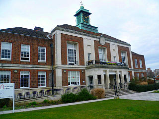
Redditch Borough Council is the local authority for Redditch, a non-metropolitan district with borough status in Worcestershire, England.

<span class="mw-page-title-main">Hillingdon Civic Centre</span> Municipal building in London, England

Hillingdon Civic Centre is a municipal building in the High Street, Uxbridge. The civic centre, which is the headquarters of Hillingdon London Borough Council, is a Grade II listed building.

<span class="mw-page-title-main">Leyton Town Hall</span> Municipal building in London, England

Leyton Town Hall is a municipal building in Adelaide Road, Leyton, London. The building, which includes Leyton Great Hall, is a Grade II listed building.

<span class="mw-page-title-main">Wallington Town Hall</span> Municipal building in London, England

Wallington Town Hall is a municipal building in Woodcote Road, Wallington, London. It is a Grade II listed building.

<span class="mw-page-title-main">Chippenham Town Hall</span> Municipal building in Chippenham, Wiltshire, England

Chippenham Town Hall is a 19th-century municipal building in the High Street, Chippenham, Wiltshire, England. The town hall, which was the headquarters of Chippenham Borough Council, is a Grade II listed building.

<span class="mw-page-title-main">Redditch Library</span> Library in the United Kingdom

Redditch Library is a library in the centre of Redditch, United Kingdom. Constructed for £550,000 and opened on 24 January 1976, it is the town's main public library, having been purpose-built to replace the former building on Church Green. It is the second-largest library in Worcestershire and attracts up to 12,500 visitors a month. It was renovated in 2009 for just over £1,000,000. It is currently in the public consultation phase of a project, led by Redditch Borough Council, to demolish the building and relocate the service to Redditch Town Hall.

<span class="mw-page-title-main">Upton-upon-Severn Memorial Hall</span> Municipal building in Upton-upon-Severn, Worcestershire, England

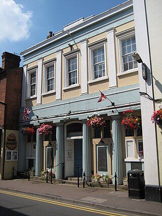
Upton-upon-Severn Memorial Hall, formerly known as Upton-upon-Severn Town Hall, is a municipal building in Old Street in Upton-upon-Severn, a town in Worcestershire in England. The building, which serves as the offices and meeting place of Upton-upon-Severn Town Council, is a Grade II listed building.

References

  1. Kelly's Directory of Worcestershire. London. 1912. p. 223. Retrieved 21 September 2022.{{cite book}}: CS1 maint: location missing publisher (link)
  2. "Redditch UD". Vision of Britain. Retrieved 6 April 2024.
  3. "The First Settlement was connected with Bordesley Abbey" (PDF). The Redditch Indicator (Centenary Supplement). 25 September 1959. p. 6. Retrieved 6 April 2024.
  4. "Town Walks South" (PDF). Redditch Walks. Retrieved 6 April 2024.
  5. Local Government Act 1972. 1972 c.70. The Stationery Office Ltd. 1997. ISBN   0-10-547072-4.
  6. 1 2 Webley, Andie (2020). Case Study: Redditch New Town (PDF). Worcestershire County Council and Historic England. Retrieved 5 April 2024.
  7. "Ordnance Survey Map". 1900. Retrieved 6 April 2024.
  8. Brooks, Alan; Pevsner, Nikolaus (2007). Worcestershire (Buildings of England Series). Yale University Press. p. 552. ISBN   978-0300112986.
  9. Hattersley, Roy (1987). Economic Priorities for a Labour Government. Palgrave Macmillan UK. p. 27. ISBN   978-1349186082.
  10. "Funds Locked Abroad". The Guardian. 15 October 1984. Retrieved 6 April 2024.
  11. "Creating a one stop community hub". AEW Architects. 16 August 2023. Retrieved 5 April 2024.
  12. "Worcester's The Hive inspiration behind scheme to revamp this town centre building". Planet Radio. 17 May 2023. Retrieved 6 April 2024.
  13. Jones, Lucy-Ann (27 July 2023). "Plans to change Redditch Town Hall into a Community Hub approved". Redditch Advertiser. Retrieved 5 April 2024.
  14. "Town hall in Redditch could become a community centre". Minuteman Press. 7 June 2023. Retrieved 6 April 2024.
  15. "New community mental health hub unveiled in Redditch". Herefordshire and Worcestershire Health and Care NHS Trust. 24 October 2023. Retrieved 6 April 2024.
  16. Chaloner, Lauren (25 March 2024). "Redditch Borough Council services move for Town Hall works". Redditch Advertiser. Retrieved 5 April 2024.