
Deadwood is a city in and county seat of Lawrence County, South Dakota, United States. It was named by early settlers after the dead trees found in its gulch. The city had its heyday from 1876 to 1879, after gold deposits had been discovered there, leading to the Black Hills Gold Rush. At its height, the city had a population of 25,000, and attracted larger-than-life Old West figures including Wyatt Earp, Calamity Jane, and Wild Bill Hickok.

Hill City is the oldest existing city in Pennington County, South Dakota, United States. The population was 948 at the 2010 census. Hill City is located 26 miles (42 km) southwest of Rapid City on U.S. Highway 16 and on U.S. Route 385 that connects Deadwood to Hot Springs. Hill City is known as the "Heart of the Hills", a distinction derived from its proximity to both the geographical center of the Black Hills, and the local tourist destinations.
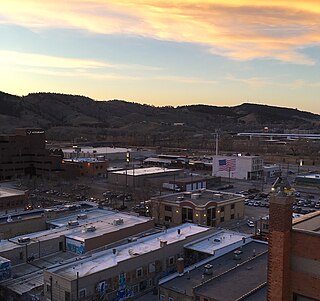
Rapid City is the second most populous city in South Dakota and the county seat of Pennington County. Named after Rapid Creek, where the settlement developed, it is in the western part of the state, located on the eastern slope of the Black Hills mountain range. The population was 67,956 as of the 2010 Census.

The Homestake Mine was a deep underground gold mine located in Lead, South Dakota. Until it closed in 2002 it was the largest and deepest gold mine in North America. The mine produced more than forty million troy ounces of gold during its lifetime. This is about 70.75 m3 or a volume of gold roughly equal to 18 677 gallons.

Four Corners is a small unincorporated community in Weston County, Wyoming, United States. It is located in northeastern Wyoming near the Bear Lodge Mountains, part of the Black Hills, at the intersection of U.S. Route 85 and Wyoming Highway 585. It is located north of Newcastle, southeast of Sundance, Wyoming, and southwest of Lead, South Dakota. Originally a stage station on the famous stagecoach road Cheyenne Black Hills Stage Route connecting Cheyenne and the Union Pacific Railroad with the gold fields of Deadwood, it is today the site of a small store, bed-and-breakfast ranches, vacation homes, and tourist camps. Camp Mallo is nearby.
The Black Hills Gold Rush took place in Dakota Territory in the United States. It began in 1874 following the Custer Expedition and reached a peak in 1876-77.
Johnson Siding is an unincorporated community in Pennington County, South Dakota, United States. The population as of the 2010 census was 659. It is located in the Rimrock Area, approximately 10 miles west of Rapid City. Johnson Siding is surrounded by the Black Hills National Forest. It is the only significant business district in the Rimrock Area, with a gas station/general store, deli, casino, tavern, the Johnson Siding Volunteer Fire Department firehouse, the Rimrock Evangelical Free Church meetinghouse, and a community center. However, most inhabitants work in Rapid City or Deadwood.

Spearfish Canyon is a deep but narrow gorge carved by Spearfish Creek located in Lawrence County, South Dakota, U.S., just south of Spearfish. The canyon is located within the Black Hills, located on the northern edge of the Black Hills National Forest. The Spearfish Canyon Scenic Byway travels through the Canyon from Spearfish to Cheyenne Crossing along U.S. Route 14A. The highway follows an old railroad grade that was abandoned after massive flooding in 1933.

The Black Hills are a small and isolated mountain range rising from the Great Plains of North America in western South Dakota and extending into Wyoming, United States. Black Elk Peak, which rises to 7,244 feet (2,208 m), is the range's highest summit. The Black Hills encompass the Black Hills National Forest. The name "Black Hills" is a translation of the Lakota Pahá Sápa. The hills were so-called because of their dark appearance from a distance, as they were covered in trees.

Carbonate, also known as Carbonate Camp, West Virginia, Virginia, and Carbonate City (1881-1939), is a ghost town located in Lawrence County, South Dakota, United States.
Greenwood, also known as Laflin,, is a ghost town in Lawrence County, South Dakota, United States. According to the book “Deadwood Saints and Sinners” by Jerry L. Bryant and Barbara Fifer, Robert Flormann died of pneumonia in Nome, Alaska, on July 4, 1900 and is buried in Seattle, page 168.
Myers City, today called Myersville, is a ghost town in Pennington County, South Dakota, United States.
Rochford is an unincorporated community in Pennington County, South Dakota, United States. It is not tracked by the U.S. Census Bureau.
Roubaix, formerly known as Perry or Lewisville, is an unincorporated community in Lawrence County, South Dakota, United States. It is not monitored by the U.S. Census Bureau.
Nahant or West Nahant is a ghost town in Lawrence County, South Dakota, United States. It flourished as a logging and, to a lesser extent, mining town in the late 19th and early 20th centuries.
Sheridan, originally called Golden City, was an early mining camp in Pennington County, South Dakota, United States. It was the first county seat of Pennington County, from 1877 to 1878. It is now submerged under Sheridan Lake.
The Rapid City, Black Hills and Western Railroad, also known simply as the Black Hills and Western Railroad and commonly referred to as the Rapid Canyon Line or the Crouch Line, is a defunct standard gauge freight railroad line that operated in the Black Hills in the U.S. state of South Dakota. The railroad became known throughout the area for its crookedness and later became a tourist attraction. It ran from Rapid City to Mystic for a distance of 36.043 miles. The railroad ceased operations in 1947.

Terraville is a ghost town in Lawrence County, South Dakota, United States. It was founded in 1877 as a mining camp and later evolved into a town. It was purchased by the Homestake Mining Company and was destroyed in 1982 to make way for a new mine.
The Thoen Stone is a sandstone slab dated 1834 that was discovered in the Black Hills of South Dakota by Louis Thoen in 1887. The discovery of the stone called into question the first discovery of gold and the history of gold mining in the Black Hills; it would mean that gold was discovered in the Black Hills 40 years before the Custer Expedition of 1874 and the subsequent Black Hills Gold Rush. It is currently on display at the Adams Museum & House in Deadwood, South Dakota.
U.S. Route 385 (US 385) is a part of the United States Numbered Highway System that travels from Big Bend National Park in Texas to US 85 in Deadwood, South Dakota. Within the state of Nebraska, the highway is known as the Gold Rush Byway, one of nine scenic byways across the state. The highway follows along the old Sidney-Black Hills trail which played a crucial role during the Black Hills Gold Rush in the late 1870s. It served as the primary route to transport gold and mining gear between Sidney, Nebraska and the Black Hills to the north. Today, the highway enters Nebraska in the southeastern portion of the Nebraska Panhandle on the state line with Colorado northeast of Julesburg and continues in a northerly direction to the South Dakota state line north of Chadron.
