
Kiowa County is a county located in the southwestern part of the U.S. state of Oklahoma. As of the 2020 census, the population was 8,509. Its county seat is Hobart. The county was created in 1901 as part of Oklahoma Territory. It was named for the Kiowa people.

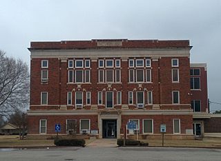
Jackson County is a county located in the southwestern corner of the U.S. state of Oklahoma. As of the 2020 census, the population was 24,785. Its county seat is Altus. According to the Encyclopedia of Oklahoma History and Culture, the county was named for two historical figures: President Andrew Jackson and Confederate General Stonewall Jackson. One source states that the county was named only for the former president, while an earlier source states it was named only for General Stonewall Jackson.
Harmon County is a county in the southwest corner of the U.S. state of Oklahoma. As of the 2020 Census, the population was 2,488, making it the second-least populous county in Oklahoma, behind only Cimarron County. It has lost population in every census since 1930. The county seat is Hollis.

Greer County is a county located along the southwest border of the U.S. state of Oklahoma. As of the 2020 census, the population was 5,491. Its county seat is Mangum. From 1860 to 1896, the state of Texas claimed an area known as Greer County, Texas, which included present-day Greer County along with neighboring areas. In 1896 it was designated as a county in Oklahoma Territory under a ruling by the US Supreme Court. The rural Greer County is home to Quartz Mountain State Park, near the community of Lone Wolf, Oklahoma. It is also home to the Oklahoma State Reformatory, located in Granite. Its population has declined since 1930 due to changes in agriculture and migration to cities for work.

Delaware County is a county located in the U.S. state of Oklahoma. As of the 2020 census, the population was 40,397. Its county seat is Jay. The county was named for the Delaware Indians, who had established a village in the area prior to the Cherokees being assigned to relocate to Indian Territory in the 1830s. Delaware County was created in 1907. Prior to becoming Delaware County, a large portion of the area was known as the Delaware District of the Cherokee Nation. Today, Delaware County continues to be recognized by the Cherokee Nation as the Delaware District.

Custer County is a county located in the U.S. state of Oklahoma. As of the 2020 census, the population was 28,513. Its county seat is Arapaho. The county was named in honor of General George Armstrong Custer.
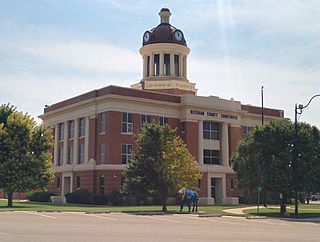
Beckham County is a county located on the western border of the U.S. state of Oklahoma. As of the 2020 census, the population was 22,410. Its county seat is Sayre. Founded upon statehood in 1907, Beckham County was named for J. C. W. Beckham, who was Governor of Kentucky and the first popularly elected member of the United States Senate from Kentucky. Beckham County comprises the Elk City, OK Micropolitan Statistical Area.
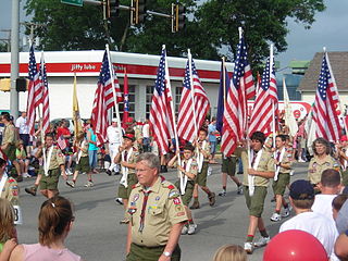
Scouting in Oklahoma has a long history, from the 1910s to the present day, serving thousands of youth in programs that suit the environment in which they live.

Jay is a city and county seat of Delaware County, Oklahoma, United States. The population was 2,448 at the 2010 census, compared to 2,482 at the 2000 census, a decrease of 1.4 percent. Almost 40% of its residents are Native American, thus Jay is home to numerous Cherokee tribal offices and a health clinic for the Delaware District of the Cherokee Nation. Jay has a council-manager system of government. Becki Farley is the mayor with Kyle Stump serving as Vice Mayor.

Mangum is a city in and county seat of Greer County, Oklahoma, United States. The population was 3,010 at the 2010 census. It was originally part of Old Greer County in the Texas panhandle. The community was named for A. S. Mangum, who owned the land on which the town was founded in 1882. It became part of the Oklahoma Territory in 1896, and thus part of the state of Oklahoma on November 16, 1907.

Lee, also known as Lee Green, is an area of South East London, England, straddling the border of the London Borough of Lewisham and the Royal Borough of Greenwich. It is located northwest of Eltham and southeast of Lewisham. Historically it has been part of the historic county of Kent.

U.S. Route 56 is an east–west United States highway that runs for approximately 640 miles (1,030 km) in the Midwestern United States. US 56's western terminus is at Interstate 25 Business, US 412 and New Mexico State Road 21 in Springer, New Mexico and the highway's eastern terminus is at US 71 in Kansas City, Missouri. Much of it follows the Santa Fe Trail.

U.S. Route 270 (US 270) is a spur of US 70. It travels for 643 miles (1,035 km) from Liberal, Kansas at US 54 and US 83 to White Hall, Arkansas at Interstate 530 (I-530) and US 65. It travels through the states of Arkansas, Oklahoma, and Kansas. It travels through the cities of Oklahoma City, Oklahoma, Hot Springs, Arkansas, and McAlester, Oklahoma.

Greer County, a county created by the Texas legislature on February 8, 1860, was land claimed by both Texas and the United States. The region of Greer County is now in present-day Oklahoma.

Highway 16 is an east–west state highway in Arkansas. The route begins in Siloam Springs at US Highway 412 (US 412) and Highway 59 and runs east through Fayetteville and the Ozark National Forest to US Highway 67 Business (US 67B) in Searcy. Highway 16 was created during the 1926 Arkansas state highway numbering, and today serves as a narrow, winding, 2-lane road except for overlaps of 10 miles (16 km) through Fayetteville. Much of the highway winds through the Ozarks, including the Ozark National Forest, where a portion of the highway is designated as an Arkansas Scenic Byway. The route has two spur routes in Northwest Arkansas; in Fayetteville and Siloam Springs.

Ponders End is the southeasternmost part of Enfield, north London, centred on the Hertford Road. Situated to the west of the River Lee Navigation, it became industrialised through the 19th century, similar to the Lea Valley in neighbouring Edmonton and Brimsdown, with manufacturing giving way to warehousing in the late-20th century. The area features much social housing, with streets also lined with suburban terraced housing from the 19th and early 20th centuries.

State Highway 34 is a state highway in the U.S. state of Oklahoma. It runs for 188.3 miles (303.0 km) south-to-north in the western part of the state. The highway begins northeast of Eldorado, in the southwest corner of the state, and extends north to the Kansas state line between Woodward and Coldwater, Kansas.

State Highway 44 is a state highway in the western portion of the U.S. state of Oklahoma. It runs for 59.2 miles (95.3 km), beginning north of Blair in Greer County, and proceeding north to Butler in Custer County. It is not to be confused with Interstate 44. The highway has one lettered spur route, SH-44A.

U.S. Highway 59 (US-59) heads along the eastern portion of the state of Oklahoma. US-59's 216.47-mile (348.37 km) route through Oklahoma takes it through the mountainous terrain of the eastern Oklahoma Ouachitas and Ozarks. US-59 serves several lakes and towns through Oklahoma's Green Country, including Grand Lake, a major recreation center. The route enters the state from Arkansas near Fogel, Arkansas, and ends at the Kansas state line south of Chetopa, Kansas.


