Live RSN data from >100 seafloor and water column instruments will be made available live on the Internet. This will allow both scientists and the general public to study long-term changes in ocean systems over the next 25 years.
The Regional Scale Nodes (RSN) is a component of the National Science Foundation's (NSF's) Ocean Observatories Initiative (OOI). The NSF's OOI is managed and coordinated by the OOI Project Office at the Consortium for Ocean Leadership (COL) in Washington, D.C. The UW, located in Seattle, Washington, is the RSN Implementing Organization for the COL.
The vision behind RSN is to launch a new era of scientific discovery and understanding of the oceans.
The RSN consists of two infrastructures: primary and secondary. The primary infrastructure network, which was designed, qualified, manufactured, and installed in 2012 by L-3 Maripro, consists of a shore facility located in Pacific City, Oregon; two fiber-optic cable lines covering a distance of 800 kilometers, and seven primary science nodes.
The RSN system delivers 200 kilowatts of power and 240Gbit/s of TCP/IP Internet data communications to the seven primary science nodes. RSN is designed to last for 25 years and is capable of significant expansion to serve future science needs.
Prior to the emergence of underwater cabled observatories, oceanographers and other researchers studying the global ocean tended to rely on the use of research vessels and manned submersibles in order to collect data. This was followed by a shift toward Remote Operated Vehicles (ROV's) and space-based research satellites. The limitation to these methods was that they were either not cost-effective, or data could only be collected for short durations. While the importance of expedition-based exploration was recognized, a solution was needed.
In 1987, the concept of utilizing high-power, high-bandwidth underwater cabled observatories emerged as a long-term, cost-effective solution for conducting real-time monitoring of ocean systems.
In the early 1990s, the United States and Canada formed an agreement to develop a plate-scale submarine electro-optically cabled ocean observatory in the northeast Pacific Ocean. This region is home to the smallest of Earth's tectonic plates – the Juan de Fuca plate. The small size and close coastal proximity of the Juan de Fuca plate presents a unique opportunity to observe the dynamic systems in submarine volcano regions.
The partnership between the U.S. and Canada developed into a plan to build a Canadian cabled array that would cover the upper 1/3 of the Juan de Fuca plate, and a U.S. system spanning the lower 2/3 of the plate (cite). Together, this plate-scale observatory would be called NEPTUNE (Northeast Pacific Time Series Underwater Networked Experiments) and would provide continuous observations for 25 years.
By the mid-2000s, NEPTUNE Canada had received full funding and their cabled array was completed and online by 2009. It was brought under the umbrella network of Ocean Networks Canada (ONC). Meanwhile, NEPTUNE U.S. was renamed to Regional Scale Nodes and became a component of the OOI. It is slated for completion in 2014. Both NEPTUNE Canada and RSN will be integrated through the ONC's digital infrastructure and the OOI Cyberinfrastructure providing real-time access to anyone connected to the Internet.
"The goal of the program is to launch an era of scientific discovery and understanding across and within the ocean basins, utilizing widely accessible, interactive telepresence. It's a new world. We will be present throughout the volume of the ocean, at will, communicating in real time...So what can we actually do tomorrow? We're about to ride the wave of technological opportunity. There are emerging technologies throughout the field around oceanography, which we will incorporate into oceanography, and through that convergence, we will transform oceanography into something even more magical."
John Delaney, RSN Program Director and Principal Investigator
Scientific Motivation
The scientific goals of RSN are significant. A vast array of natural phenomena that occur throughout the world's oceans and seafloor are found in the Northeast Pacific Ocean. As a whole, the mission of RSN is to provide a human telepresence in the ocean that will serve researchers, students, educators, policymakers, and the public. Scientists will be able to conduct local investigations of such global processes as major ocean currents, active earthquake zones, creation of new seafloor, and rich environments of marine plants and animals.
OOI Seafloor processes. Image Credit: OOI Regional Scale Nodes program and the Center for Environmental Visualization, University of Washington
The existence of a long-term cabled observatory will allow for long-term measurements of biological communities. In particular, the Juan de Fuca plate's divergent plate boundary has resulted in the existence of seafloor hydrothermal vents ecosystems, and other similar groups. These deep sea communities, thriving in extremely harsh environments, pose a number of unsolved scientific questions which RSN will be capable of investigating.
Infrastructure
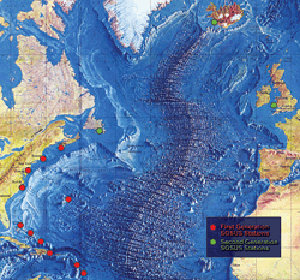
Regional Scale Nodes Station Maps
Primary Infrastructure
The primary infrastructure of RSN consists of seven primary nodes which were installed in 2012 by L-3 Maripro. They are terminal points which help distribute power and bandwidth to the networks of deployed sensors.
Approximately 900 kilometers of cable (referred to as backbone cable) have been used to connect the primary nodes together. These cables make landfall at the shore station in Pacific, City, Oregon.
In 2005, over 175 scientists across the United States responded to a Request for Assistance from the National Science Foundation to develop a cabled observatory on the Juan de Fuca Plate. Nodes are located at pre-selected experimental sites throughout the Juan de Fuca plate. Axial Seamount, Hydrate Ridge on the Cascadia Margin and shallow water sites west of Newport, Oregon (the Endurance Array) all have primary nodes installed. The primary nodes are all located in environmentally benign areas.
Nodes also convert the 10kVdc voltage levels from the backbone cable to 375Vdc which is then directed to the secondary infrastructure. The 375V switching systems and Node telemetry systems were designed and manufactured by Texcel Technology Plc based in England. The software to manage the ports and telemetry protection systems was also supplied by Texcel as an element manager sitting under a Network Management System (NMS).
The primary nodes have a number of extra ports which offer the potential for large-scale future expansion (>100 kilometers).
Secondary Infrastructure
The converted 375Vdc voltage from the primary nodes is then directed at low-and medium-power nodes and junction boxes. The nodes and junction boxes (similar to power strips) offer direct power and communications to the instruments at the experimental sites. In concert, these parts make up the RSN secondary infrastructure. Extension cables are used to link the primary nodes to the secondary infrastructure, providing power and communications.
Equipment is linked using wet-mate connectors. Different types of cable were installed depending on load requirements. Bandwidth from these cables ranges from 10Gbit/s to 1Gbit/s.
During the VISIONS ’13 expedition to continue construction of RSN, over 22,000 meters of extension cables were installed on the ocean floor. The cables all successfully went online.
Upon completion in 2014, over 100 cabled seafloor and water column instruments will be operational. These instruments will allow monitoring of biological, chemical, geological, and geophysical processes in the ocean. The secondary infrastructure will also include six mooring systems for water-column profilers.
Cables are frequently deployed all across the world in ocean basins and margins. They have considerably long lifetimes. The backbone cable was installed in the summer of 2011. The commercial cable-laying ship, TE SubCom Dependable, carried out this phase of the project.
Special environmental requirements were also taken into account. Certain cables are substantially well-armored, especially those deployed in volcanic areas, such as Axial Seamount.
Images taken by ROPOS during RSN construction and survey dives
Instruments
ROPOS prepares to deploy a shallow profiler Credit: M. Elend, University of Washington
In order to fully understand complex ocean systems, a wide variety of sensor arrays, capable of surviving for long periods of time in harsh conditions, are necessary. A suite of sensors (over 100) were selected and strategically placed throughout RSN. They are located at Axial Seamount, Hydrate Ridge, and also on the water-column moorings.
Instruments connected to the RSN include:
Conductivity Temperature Depth (located on profilers)
Dissolved Oxygen,
3-D Single Point Current Meter
Temperature
Fluorometers
CDOM,
Chlorophyll-a,
Optical Backscatter
The instruments are the final spot of each regional network branch.
Cyberinfrastructure
CI Deployment Topology. Graphic created by J.B. Matthews.
The Regional Scale Nodes is connected into the OOI Cyberinfrastructure.
The Cyberinfrastructure component of the OOI links marine infrastructure to scientists and users. The OOI Cyberinfrastructure manages and integrates data from all the different OOI sensors. It will provide a common operating infrastructure, the Integrated Observatory Network (ION), connecting and coordinating the operations of the marine components (global, regional, and coastal scale arrays). It will also provide resource management, observatory mission command and control, product production, data management and distribution (including strong data provenance), and centrally available collaboration tools.
The Integrated Observatory Network (ION) connects and coordinates the operations of the OOI marine components with the scientific and educational pursuits of oceanographic research communities. The cyberinfrastructure is being designed and constructed by the University of California, San Diego.
Status
Construction of RSN is ongoing. As of September 19, 2014, the primary infrastructure and most of the secondary infrastructure was successfully in place, and OOI RSN and UW APL crews were working to complete the vertical moorings for the shallow profiler.
Outreach
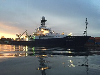
The University of Washington has welcomed student participation in the implementation of RSN. As of 2014, there have been eight expeditions in which students have had the opportunity to work aboard the R/V Thomas G. Thompson and witness the construction of the cabled observatory. During these cruises, students develop projects utilizing the array of technology and scientific equipment on board.
Students who participate in these expeditions go on to share their experiences with others.
In 2014, over 30 graduate and undergraduate students worked alongside the researchers, engineers, educators, and crew during the 83-day VISIONS ’14 expedition.
Related Research Articles
Sound Surveillance System (SOSUS) was the original name for a submarine detection system based on passive sonar developed by the United States Navy to track Soviet submarines. The system's true nature was classified with the name and acronym SOSUS classified as well. The unclassified name Project Caesar was used to cover the installation of the system and a cover story developed regarding the shore stations, identified only as a Naval Facility (NAVFAC), being for oceanographic research. The name changed to Integrated Undersea Surveillance System (IUSS) in 1985, as the fixed bottom arrays were supplemented by the mobile Surveillance Towed Array Sensor System (SURTASS) and other new systems. The commands and personnel were covered by the "oceanographic" term until 1991 when the mission was declassified. As a result, the commands, Oceanographic System Atlantic and Oceanographic System Pacific became Undersea Surveillance Atlantic and Undersea Surveillance Pacific, and personnel were able to wear insignia reflecting the mission.
Marine geology or geological oceanography is the study of the history and structure of the ocean floor. It involves geophysical, geochemical, sedimentological and paleontological investigations of the ocean floor and coastal zone. Marine geology has strong ties to geophysics and to physical oceanography.
R/V Roger Revelle is a Thomas G. Thompson-class oceanographic research ship operated by Scripps Institution of Oceanography under charter agreement with Office of Naval Research as part of the University-National Oceanographic Laboratory System (UNOLS) fleet. The ship is named after Roger Randall Dougan Revelle, who was essential to the incorporation of Scripps into the University of California San Diego.
The Juan de Fuca Ridge is a mid-ocean spreading center and divergent plate boundary located off the coast of the Pacific Northwest region of North America, named after Juan de Fuca. The ridge separates the Pacific Plate to the west and the Juan de Fuca Plate to the east. It runs generally northward, with a length of approximately 500 kilometres (310 mi). The ridge is a section of what remains from the larger Pacific-Farallon Ridge which used to be the primary spreading center of this region, driving the Farallon Plate underneath the North American Plate through the process of plate tectonics. Today, the Juan de Fuca Ridge pushes the Juan de Fuca Plate underneath the North American plate, forming the Cascadia Subduction Zone.
The NEPTUNE Ocean Observatory project is part of Ocean Networks Canada which is a University of Victoria initiative. NEPTUNE is the world's first regional-scale underwater ocean observatory that plugs directly into the Internet. NEPTUNE is the largest installation on the Ocean Networks Canada network of ocean observatories. Since December 2009, it has allowed people to "surf" the seafloor while ocean scientists run deep-water experiments from labs and universities around the world. Along with its sister project, VENUS, NEPTUNE offers a unique approach to ocean science. Traditionally, ocean scientists have relied on infrequent ship cruises or space-based satellites to carry out their research, while the NEPTUNE project uses a remotely operated crawler.
VENUS - is one of two principal cabled seafloor observatories operated by Ocean Networks Canada at the University of Victoria, British Columbia, Canada.
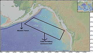
Axial Seamount is a seamount, submarine volcano, and underwater shield volcano in the Pacific Ocean, located on the Juan de Fuca Ridge, approximately 480 km (298 mi) west of Cannon Beach, Oregon. Standing 1,100 m (3,609 ft) high, Axial Seamount is the youngest volcano and current eruptive center of the Cobb–Eickelberg Seamount chain. Located at the center of both a geological hotspot and a mid-ocean ridge, the seamount is geologically complex, and its origins are still poorly understood. Axial Seamount is set on a long, low-lying plateau, with two large rift zones trending 50 km (31 mi) to the northeast and southwest of its center. The volcano features an unusual rectangular caldera, and its flanks are pockmarked by fissures, vents, sheet flows, and pit craters up to 100 m (328 ft) deep; its geology is further complicated by its intersection with several smaller seamounts surrounding it.
The Cobb-Eickelberg seamount chain is a range of undersea mountains formed by volcanic activity of the Cobb hotspot located in the Pacific Ocean. The seamount chain extends to the southeast on the Pacific Plate, beginning at the Aleutian Trench and terminating at Axial Seamount, located on the Juan de Fuca Ridge. The seamount chain is spread over a vast length of approximately 1,800 km. The location of the Cobb hotspot that gives rise to these seamounts is 46° N—130° W. The Pacific plate is moving to the northwest over the hotspot, causing the seamounts in the chain to decrease in age to the southeast. Axial is the youngest seamount and is located approximately 480 km west of Cannon Beach, Oregon. The most studied seamounts that make up this chain are Axial, Brown Bear, Cobb, and Patton seamounts. There are many other seamounts in this chain which have not been explored.
The Ocean Observatories Initiative (OOI) is a National Science Foundation (NSF) Major Research Facility composed of a network of science-driven ocean observing platforms and sensors in the Atlantic and Pacific Oceans. This networked infrastructure measures physical, chemical, geological, and biological variables from the seafloor to the sea surface and overlying atmosphere, providing an integrated data collection system on coastal, regional and global scales. OOI's goal is to deliver data and data products for a 25-year-plus time period, enabling a better understanding of ocean environments and critical ocean issues.
The following outline is provided as an overview of and introduction to Oceanography.
The following are considered ocean essential climate variables (ECVs) by the Ocean Observations Panel for Climate (OOPC) that are currently feasible with current observational systems.
The Endeavour Hydrothermal Vents are a group of hydrothermal vents in the north-eastern Pacific Ocean, located 260 kilometres (160 mi) southwest of Vancouver Island, British Columbia, Canada. The vent field lies 2,250 metres (7,380 ft) below sea level on the northern Endeavour segment of the Juan de Fuca Ridge. In 1982, dredged sulfide samples were recovered from the area covered in small tube worms and prompted a return to the vent field in August 1984, where the active vent field was confirmed by HOV Alvin on leg 10 of cruise AII-112.
The Sentry is an autonomous underwater vehicle (AUV) made by the Woods Hole Oceanographic Institution. Sentry is designed to descend to depths of 6,000 metres (20,000 ft) and to carry a range of devices for taking samples, pictures and readings from the deep sea.
A cabled observatory is a seabed oceanographic research platform connected to land by cables that provide power and communication. Observatories are outfitted with a multitude of scientific instruments that can collect many kinds of data from the seafloor and water column. By removing the limitations of undersea power sources and sonar or RF communications, cabled observatories allow persistent study of underwater phenomena. Data from these instruments is relayed to a land station and data networks, such as Ocean Networks Canada, in real time.
European Multidisciplinary Seafloor and water-column Observatory (EMSO) is a large-scale European distributed Research Infrastructure for ocean observation, enabling real-time interactive long term monitoring of ocean processes. EMSO allows study of the interaction between the geosphere, the biosphere, the hydrosphere, and the lithosphere; including natural hazards, climate change, and marine ecosystems. EMSO nodes have been deployed at key sites in European seas, starting from the Arctic, through the Atlantic and Mediterranean, to the Black Sea.
Ocean Networks Canada is a world-leading research and ocean observing facility hosted and owned by the University of Victoria, and managed by the not-for profit ONC Society. ONC operates unparalleled observatories in the deep ocean and coastal waters of Canada’s three coasts–the Arctic, the Pacific and the Atlantic–gathering biological, chemical, geological and physical data to drive solutions for science, industry and society. ONC operates the NEPTUNE and VENUS cabled ocean observatories in the northeast Pacific Ocean and the Salish Sea. Additionally, Ocean Networks Canada operates smaller community-based observatories offshore from Cambridge Bay, Nunavut., Campbell River, Kitamaat Village and Digby Island. These observatories collect data on physical, chemical, biological, and geological aspects of the ocean over long time periods. As with other ocean observatories such as ESONET, Ocean Observatories Initiative, MACHO and DONET, scientific instruments connected to Ocean Networks Canada are operated remotely and provide continuous streams of freely available data to researchers and the public. Over 200 gigabytes of data are collected every day.
Quileute Canyon is a submarine canyon, off of Washington state, United States.
Southern Hydrate Ridge, located about 90 km offshore Oregon Coast, is an active methane seeps site located on the southern portion of Hydrate Ridge. It extends 25 km in length and 15 km across, trending north-northeast-south-southwest at the depth of approximately 800 m. Southern Hydrate Ridge has been the site of numerous submersible dives with the human occupied Alvin submarine, extensive visits by numerous robotic vehicles including the Canadian ROV ROPOS, Jason , and Tiburon (MBARI), and time-series geophysical studies that document changes in the subsurface distribution of methane. It is also a key site of the National Science Foundations Regional Cabled Array that is part of the Ocean Observatories Initiative (OOI), which includes eight types of cabled instruments streaming live data back to shore 24/7/365 at the speed of light, as well as uncabled instruments.
Deborah Sue Kelley is a marine geologist who studies hydrothermal vents, active submarine volcanoes, and life in these regions of the deep ocean.
Suzanne Carbotte is a marine geophysicist known for her research on the formation of new oceanic crust.
Students on the VISIONS '14 expedition prepare to deploy a CTD Credit: M. Elend, University of Washington
Delaney, John; Deborah Kelley; S. Kim Juniper (20 March 2014). "Establishing a new era of submarine volcanic observatories:Cabling Axial Seamount and the Endeavour Segment of the Juan de Fuca Ridge". Marine Geology. 352: 426–450. Bibcode:2014MGeol.352..426K. doi:10.1016/j.margeo.2014.03.010.
This page is based on this Wikipedia article Text is available under the CC BY-SA 4.0 license; additional terms may apply. Images, videos and audio are available under their respective licenses.