The country of Brazil occupies roughly half of South America, bordering the Atlantic Ocean. Brazil covers a total area of 8,514,215 km2 (3,287,357 sq mi) which includes 8,456,510 km2 (3,265,080 sq mi) of land and 55,455 km2 (21,411 sq mi) of water. The highest point in Brazil is Pico da Neblina at 2,994 m (9,823 ft). Brazil is bordered by the countries of Argentina, Bolivia, Colombia, Guyana, Paraguay, Peru, Suriname, Uruguay, Venezuela, and France.

Tocantins is one of the 26 states of Brazil. It is the newest state, formed in 1988 and encompassing what had formerly been the northern two-fifths of the state of Goiás. Tocantins covers 277,620.91 square kilometres (107,190.03 sq mi) and had an estimated population of 1,496,880 in 2014. Construction of its capital, Palmas, began in 1989; most of the other cities in the state date to the Portuguese colonial period. With the exception of Araguaína, there are few other cities with a significant population in the state. The government has invested in a new capital, a major hydropower dam, railroads and related infrastructure to develop this primarily agricultural area. The state has 0.75% of the Brazilian population and is responsible for 0.5% of the Brazilian GDP.
Goiás is a Brazilian state located in the Center-West region. Goiás borders the Federal District and the states of Tocantins, Bahia, Minas Gerais, Mato Grosso do Sul and Mato Grosso. The state capital is Goiânia. With 7.2 million inhabitants, Goiás is the most populous state in the Center-West and the 11th most populous in the country. It has the ninth largest economy among Brazilian federative units. In Brazil's geoeconomic division, Goiás belongs to the Centro-Sul (Center-South), being the northernmost state of the southern portion of Brazil. The state has 3.3% of the Brazilian population and is responsible for 2.7% of the Brazilian GDP.

Paraná is one of the 26 states of Brazil, in the south of the country. It is bordered in the north by São Paulo state, in the east by the Atlantic Ocean, in the south by Santa Catarina state and the province of Misiones, Argentina, and in the west by Mato Grosso do Sul and Paraguay, with the Paraná River as its western boundary. It is subdivided into 399 municipalities, and its capital is the city of Curitiba. Other major cities are Londrina, Maringá, Ponta Grossa, Cascavel, São José dos Pinhais and Foz do Iguaçu. The state is home to 5.4% of the Brazilian population and generates 6.2% of the Brazilian GDP.

Mato Grosso is one of the states of Brazil, the third largest by area, located in the Central-West region. The state has 1.66% of the Brazilian population and is responsible for 1.9% of the Brazilian GDP.

Mato Grosso do Sul is one of Brazil's 27 federal units, located in the southern part of the Central-West Region, bordering five Brazilian states: Mato Grosso, Goiás and Minas Gerais (northeast), São Paulo (east) and Paraná (southeast); and two South America countries: Paraguay and Bolivia (west). It is divided into 79 municipalities and covers an area of 357,145.532 square kilometers, which is about the same size as Germany. With a population of 2,839,188 inhabitants in 2021, Mato Grosso do Sul is the 21st most populous state in Brazil.

Rondônia is one of the 26 states of Brazil, located in the northern subdivision of the country between latitudes 07º 58' 32" and 13º 41' 36" S and longitudes 59º 46' 26" and 66º 48' 21"W. To the west is a short border with the state of Acre for 22 km, to the north is the state of Amazonas for about 930 km across the Serra de São Jão, latitude 7° 58ˈ south, and north of the Mapiri-Madeira River, in the east is Mato Grosso for about 820 km across the Serra Grande, Serra de Providência and the Rio Branco, Inue (Languiaru) and Tenente Marques-Eugênia, and in the south and southwest is Bolivia for 1,464 km across the Guaporé and Abuna Rivers. Rondônia has a population of 1,815,000 as of 2021. It is the fifth least populated state. Its capital and largest city is Porto Velho, bathed by the Madeira River. The state was named after Cândido Rondon, who explored the north of the country during the 1910s. The state, which is home to c. 0.7% of the Brazilian population, is responsible for c. 0.3% of the Brazilian GDP.

Campo Grande is the capital and largest city of the Brazilian state of Mato Grosso do Sul in the Center-West region of the country. The city is nicknamed Cidade Morena because of the reddish-brown colour of the region's soil. It has a population of 906,092, according to a 2020 IBGE estimate.

Cuiabá is the capital city of the Brazilian state of Mato Grosso. It is located near the geographical centre of South America. Also, it forms the metropolitan area of Mato Grosso, along with the neighbouring town of Várzea Grande. The city's name is an indigenous Bororo word meaning 'arrow-fishing', The city was founded in 1719, during the gold rush, and it has been the state capital since 1818. The city is a trading centre for an extensive cattle-raising and agricultural area. The capital is among the fastest-growing cities in Brazil, followed by the growth of agribusiness in Mato Grosso, despite the recession that is affecting Brazilian industries. Cuiabá was one of the host cities for the 2014 FIFA World Cup.
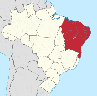
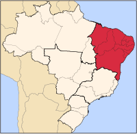
The Northeast Region of Brazil is one of the five official and political regions of the country according to the Brazilian Institute of Geography and Statistics. Of Brazil's twenty-six states, it comprises nine: Maranhão, Piauí, Ceará, Rio Grande do Norte, Paraíba, Pernambuco, Alagoas, Sergipe and Bahia, along with the Fernando de Noronha archipelago.
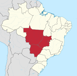
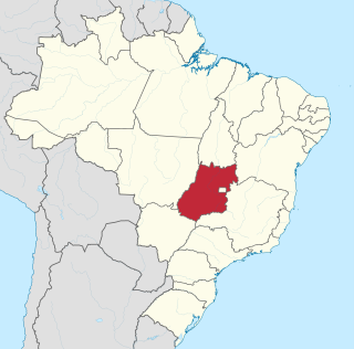
The Central-West or Center-West Region of Brazil is composed of the states of Goiás, Mato Grosso and Mato Grosso do Sul; along with Distrito Federal, where Brazil's national capital, Brasília, is situated. The region comprises 18.86% of the national territory.

The Brazilian Highway System is a network of trunk roads administered by the Ministry of Transport of Brazil. It is constructed, managed and maintained by the National Department of Transport Infrastructure (DNIT), federal agency linked to the Ministry of Infrastructure, and the public works departments of state governments.

BR-163 is a highway in Brazil, going from Tenente Portela, in the state of Rio Grande do Sul, to Santarém, Pará, on 3579 kilometers .. It was proposed to pave the road in its entirety part of the Avança Brasil project, which in 2007 was replaced by the Programa de Aceleração do Crescimento. A 51 km long stretch of the highway was finally paved in 2019 in the state of Pará in a cooperation between the Bolsonaro government and the Brazilian army engineering battalion, until the city of Miritituba, leaving only a small part of the highway to be paved on the other side of the Amazon River.

Tourism is a growing sector and key to the economy of several regions of Brazil. The country had 6.589 million visitors in 2018, ranking in terms of the international tourist arrivals as the second main destination in South America after Argentina and third in Latin America after Mexico and Argentina. Revenues from international tourists reached US$5.8 billion in 2015, continuing a recovery trend from the 2008–2009 economic crisis.

Mining in Brazil is centered on the extraction of iron, copper, gold, aluminum, manganese, tin, niobium, and nickel. About gemstones, Brazil is the world's largest producer of amethyst, topaz, agate and is a big producer of tourmaline, emerald, aquamarine, garnet and opal.
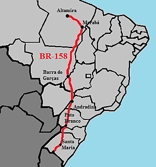
BR-158 is a federal highway of Brazil. One of the longest highways in the country, the 3,955.0-kilometre (2,457.5 mi) road connects Altamira, Pará, to Santana do Livramento on the Uruguayan border where it joins Route 5 (Uruguay).

The BR-293 is an east-west highway in the state of Rio Grande do Sul, Brazil. The highway connects Pelotas to Quaraí, crossing important cities in the southern tip of Brazil such as Bagé and Santana do Livramento. The highway measures 535.7 km.
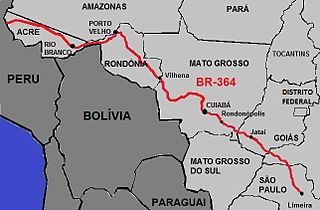
BR-364 is an inter-state highway in Brazil connecting the southeast state of São Paulo to the western state of Acre. The highway was opened in the 1960s and paved in the 1980s. It has brought economic development and population growth in the Amazon basin states of Rondônia and Acre. It is also important for the flow of agricultural and livestock production in the states of Rondônia, Mato Grosso and Goiás, for Brazilian domestic consumption and for export, predominately by Port of Santos.

In Brazil, the lords of Casa da Torre de Garcia d'Avila pioneered the livestock industry, often using indigenous labor as cowboys. However, a great drought in the Northeast and the discovery of precious minerals in Minas Gerais at the end of the 18th century moved the cattle ranch in Brazil to the Southeast and South, more specifically São Paulo and Rio Grande do Sul.
Proposals for the creation of federative units in Brazil are currently under discussion and in different stages of processing in the National Congress. The creation of 18 new states and three new federal territories were officially proposed, which would bring the total number of federative units to 48. The region with the largest number of federative units would be the North region, while the South region would be the only one with a new federative unit. The states with the most advanced stage of creation are Gurgueia and Maranhão do Sul both in the Northeast region.