Sandstone is a clastic sedimentary rock composed mainly of sand-sized silicate grains. Sandstones comprise about 20–25% of all sedimentary rocks.
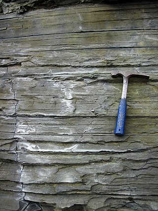
Shale is a fine-grained, clastic sedimentary rock formed from mud that is a mix of flakes of clay minerals (hydrous aluminium phyllosilicates, e.g. kaolin, Al2Si2O5(OH)4) and tiny fragments (silt-sized particles) of other minerals, especially quartz and calcite. Shale is characterized by its tendency to split into thin layers (laminae) less than one centimeter in thickness. This property is called fissility. Shale is the most common sedimentary rock.

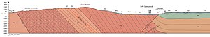
Sedimentary rocks are types of rock that are formed by the accumulation or deposition of mineral or organic particles at Earth's surface, followed by cementation. Sedimentation is the collective name for processes that cause these particles to settle in place. The particles that form a sedimentary rock are called sediment, and may be composed of geological detritus (minerals) or biological detritus. The geological detritus originated from weathering and erosion of existing rocks, or from the solidification of molten lava blobs erupted by volcanoes. The geological detritus is transported to the place of deposition by water, wind, ice or mass movement, which are called agents of denudation. Biological detritus was formed by bodies and parts of dead aquatic organisms, as well as their fecal mass, suspended in water and slowly piling up on the floor of water bodies. Sedimentation may also occur as dissolved minerals precipitate from water solution.

Greywacke or graywacke is a variety of sandstone generally characterized by its hardness, dark color, and poorly sorted angular grains of quartz, feldspar, and small rock fragments or sand-size lithic fragments set in a compact, clay-fine matrix. It is a texturally immature sedimentary rock generally found in Paleozoic strata. The larger grains can be sand- to gravel-sized, and matrix materials generally constitute more than 15% of the rock by volume.

The Morrison Formation is a distinctive sequence of Upper Jurassic sedimentary rock found in the western United States which has been the most fertile source of dinosaur fossils in North America. It is composed of mudstone, sandstone, siltstone, and limestone and is light gray, greenish gray, or red. Most of the fossils occur in the green siltstone beds and lower sandstones, relics of the rivers and floodplains of the Jurassic period.

Mudrocks are a class of fine-grained siliciclastic sedimentary rocks. The varying types of mudrocks include siltstone, claystone, mudstone, slate, and shale. Most of the particles of which the stone is composed are less than 1⁄16 mm and are too small to study readily in the field. At first sight, the rock types appear quite similar; however, there are important differences in composition and nomenclature.

Clastic rocks are composed of fragments, or clasts, of pre-existing minerals and rock. A clast is a fragment of geological detritus, chunks, and smaller grains of rock broken off other rocks by physical weathering. Geologists use the term clastic to refer to sedimentary rocks and particles in sediment transport, whether in suspension or as bed load, and in sediment deposits.

The Pennsylvanian Pottsville Formation is a mapped bedrock unit in Pennsylvania, western Maryland, West Virginia, Ohio, and Alabama. It is a major ridge-former in the Ridge-and-Valley Appalachians of the eastern United States. The Pottsville Formation is conspicuous at many sites along the Allegheny Front, the eastern escarpment of the Allegheny or Appalachian Plateau.

The Raton Formation is a geological formation of Upper Cretaceous and Paleocene age which outcrops in the Raton Basin of northeast New Mexico and southeast Colorado.

The Casselman Formation mapped sedimentary bedrock unit in Pennsylvania, Maryland, and West Virginia, of Pennsylvanian age. It is the uppermost of two formations in the Conemaugh Group, the lower being the Glenshaw Formation. The boundary between these two units is the top of the marine Ames Limestone. The Conemaugh Group overlies the Upper Freeport coal bed of the Allegheny Formation and underlies the Pittsburgh coal seam of the Monongahela Group.
Coal Rock is a prominent nunatak lying 4 nautical miles (7 km) southeast of Fierle Peak at the south end of the Forrestal Range, Pensacola Mountains. It was mapped by the United States Geological Survey (USGS) from surveys and from U.S. Navy air photos, 1956–1966, and named by Dwight L. Schmidt, USGS geologist for two beds of graphitic coal that are well exposed on the nunatak.
The Tallahatta Formation is a geologic formation found on the surface in Alabama, Florida, Georgia, and Mississippi. It is also located in the subsurface of Kentucky. The Tallahatta formation is part of the Claiborne Group and contains four members: the Basic City Shale in Mississippi, the Holy Springs Sand Member in Mississippi, the Meridian Sand Member in Alabama and Mississippi, and the Neshoba Sand Member in Mississippi. It preserves fossils dating back to the Paleogene period, specifically the Eocene.
The Sangre de Cristo Formation is a geologic formation in Colorado and New Mexico. It preserves fossils dating back to the late Pennsylvanian to early Permian.
The Poison Canyon Formation is a geologic formation in the Raton Basin of Colorado and New Mexico. The formation was deposited from the late Cretaceous through the Paleocene.

The Gallup Sandstone is a geologic formation in the Gallup-Zuni basin of New Mexico. It preserves fossils dating back to the late Cretaceous period.

The Abo Formation is a geologic formation in New Mexico. It contains fossils characteristic of the Cisuralian epoch of the Permian period.
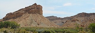
The Ferron Sandstone Member of the Mancos Shale is a geologic unit in Utah. It preserves fossils dating back to the Cretaceous period; and more specifically the middle Turonian.
The Santa Susana Formation is a Paleogene period geologic formation in the Simi Hills and western Santa Susana Mountains of southern California.
The Whitemud Formation is a geologic formation of Late Cretaceous (Maastrichtian) age in the Western Canada Sedimentary Basin. it is present through the plains of southern Saskatchewan, southeastern Alberta and south-central Alberta. Named by N.B. Davis in 1918, the formation is characterized by white kaolinitic clay and is a source of high-quality refractory clay. The type locality has been designated as Dempster's clay pit northwest of Eastend, Saskatchewan.
The Bickford Formation is a geologic formation of Early Cretaceous (Valanginian) age in the Western Canada Sedimentary Basin that consists primarily of nonmarine sediments. It is present in the northern foothills of the Canadian Rockies in northeastern British Columbia.