Roane County is a county of the U.S. state of Tennessee. As of the 2020 census, the population was 53,404. Its county seat is Kingston. Roane County is included in the Knoxville, TN Metropolitan Statistical Area.

Rhea County is a county located in the U.S. state of Tennessee. As of the 2020 census, the population was 32,870. Its county seat is Dayton. Rhea County comprises the Dayton, TN Micropolitan Statistical Area, which is also included in the Chattanooga-Cleveland-Dalton, TN-GA-AL Combined Statistical Area.

Meigs County is a county located in the U.S. state of Tennessee. As of the 2020 census, the population was 12,758. Its county seat is Decatur.

Spring City is a town in Rhea County, Tennessee, United States. The population was 1,949 at the 2020 census and 1,981 at the 2010 census. The town is located along Watts Bar Lake, and Watts Bar Dam and the Watts Bar Nuclear Generating Station are nearby.

The Piney River is a stream that drains a portion of Tennessee's Cumberland Plateau generally known as Walden Ridge. The Piney River rises near the Rhea County – Bledsoe County line and is referred to as Piney Creek in its upper reaches roughly until its confluence with Duskin Creek. Its major tributary, Little Piney Creek, flows over two spectacular waterfalls which are located in Piney Falls State Natural Area near the community of Grandview. A tributary of Little Piney Creek is Soak Creek, Tennessee's newest State Scenic River. The confluence of the two streams occurs below the falls of the smaller stream in an area referred to as "Shut-in Gap". The stream flows out of the gap and is bridged by State Route 68 just before that road begins its steep climb up the Cumberland Escarpment onto Waldens Ridge. The stream flows north of Spring City, Tennessee and becomes slack just east of the town at a headland of Watts Bar Lake, an impoundment of the Tennessee River formed by the Tennessee Valley Authority's Watts Bar Dam project. The mouth of the Piney is one of the larger bays of Watts Bar Lake and contains several small islands.

The Watts Bar Nuclear Plant is a Tennessee Valley Authority (TVA) nuclear reactor pair used for electric power generation. It is located on a 1,770-acre (7.2 km²) site in Rhea County, Tennessee, near Spring City, between the cities of Chattanooga and Knoxville. Watts Bar supplies enough electricity for about 1,200,000 households in the Tennessee Valley.
Ten Mile is an unincorporated community in northern Meigs and southeastern Roane counties in the U.S. state of Tennessee.
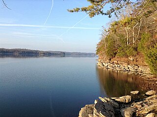
Watts Bar Lake is a reservoir on the Tennessee River created by Watts Bar Dam as part of the Tennessee Valley Authority system.

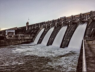
Watts Bar Dam is a hydroelectric dam on the Tennessee River in Meigs and Rhea counties in Tennessee, United States. The dam is one of nine dams on the main Tennessee River channel operated by the Tennessee Valley Authority, which built the dam in the early 1940s to provide flood control and electricity and to help create a continuous navigable channel along the entire length of the river. The dam is the technical boundary between the 39,090-acre (15,820 ha) Watts Bar Lake— which it impounds— and Chickamauga Lake, which stretches from the dam's tailwaters southward to Chattanooga.

Fort Loudoun Dam is a hydroelectric dam on the Tennessee River in Loudon County, Tennessee, in the southeastern United States. The dam is operated by the Tennessee Valley Authority (TVA), which built the dam in the early 1940s as part of a unified plan to provide electricity and flood control in the Tennessee Valley and create a continuous 652-mile (1,049 km) navigable river channel from Knoxville, Tennessee to Paducah, Kentucky. It is the uppermost of nine TVA dams on the Tennessee River.

Melton Hill Dam is a hydroelectric dam on the Clinch River just south of Oak Ridge, Tennessee, United States. The dam is operated by the Tennessee Valley Authority, which built the dam in the early 1960s to extend the Tennessee Valley's continuous navigation channel up the Clinch as far as Clinton and to increase TVA's overall power-generating capacity. The dam impounds the 5,470-acre (2,210 ha) Melton Hill Lake, and is the only TVA tributary dam serviced by a navigation lock. The dam and associated infrastructure were listed on the National Register of Historic Places in 2017.

Haletown is an unincorporated community in Marion County, Tennessee, United States. It is part of the Chattanooga, TN–GA Metropolitan Statistical Area. Haletown is probably best known as the former location of Hales Bar Dam, a major hydroelectric project completed in 1913 by the former Tennessee Electric Power Company (TEPCO) and as a prominent location along the Tennessee River at Nickajack Lake.

The Chickamauga Dam is a hydroelectric dam on the Tennessee River in Chattanooga, Tennessee, United States. The dam is owned and operated by the Tennessee Valley Authority, which built the dam in the late 1930s as part of a New Deal era initiative to improve navigation and bring flood control and economic development to the Tennessee Valley. The dam impounds the 36,240-acre (14,670 ha) Chickamauga Lake and feeds into Nickajack Lake. The dam and associated infrastructure were listed on the National Register of Historic Places in 2017.

Overhill Cherokee was the term for the Cherokee people located in their historic settlements in what is now the U.S. state of Tennessee in the Southeastern United States, on the western side of the Appalachian Mountains. This name was used by 18th-century European traders and explorers from British colonies along the Atlantic coast, as they had to cross the mountains to reach these settlements.
Loyston is a ghost town in Union County, Tennessee, United States, that was inundated by the waters of the Clinch River after the completion of Norris Dam in 1936. Established in the early 19th century around a foundry built by its namesake, John Loy, over subsequent decades the community's location along State Highway 61 helped it grow into a trading center for local farmers. By the time the Tennessee Valley Authority (TVA) began making plans to build Norris Dam in the early 1930s, Loyston had a population of approximately 70 residents, and consisted of a post office and several small businesses.
Cherokee Dam is a hydroelectric dam located on the Holston River in Grainger County and Jefferson County, Tennessee, in the southeastern United States. The dam is operated and maintained by the Tennessee Valley Authority, which built the dam in the early 1940s to help meet urgent demands for energy at the outbreak of World War II. Cherokee Dam is 175 feet (53 m) high and impounds the 28,780-acre (11,650 ha) Cherokee Lake. It has a generating capacity of 136 megawatts. The dam was named for the Cherokee, a Native American tribe that controlled much of East Tennessee when the first European settlers arrived in the mid-18th century.
Widows Bar Lock and Dam was a dam once located along the Tennessee River in Jackson County, Alabama, USA. It was situated 407 miles (655 km) above the mouth of the Tennessee River, near the river's confluence with Widows Creek. The dam was completed 8 September 1924, and was designed and operated by the U.S. Army Corps of Engineers. It was serviced by a 60-foot (18 m) by 265-foot (81 m) navigation lock. When the Tennessee Valley Authority took control of flood control and navigation improvement operations in the Tennessee Valley in the 1930s, Widows Bar was considered too high maintenance, and it was dismantled as part of the construction of Guntersville Dam.

John Randolph Neal Jr. was an American attorney, law professor, politician, and activist, best known for his role as chief counsel during the 1925 Scopes Trial, and as an advocate for the establishment of the Tennessee Valley Authority in the 1920s and 1930s. He also taught law at the University of Denver and the University of Tennessee, and served in the Tennessee state legislature. He was a candidate for governor or senator numerous times between 1912 and 1954.
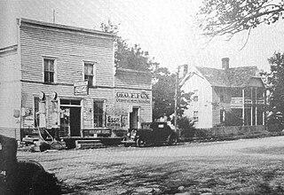
Old Washington is an unincorporated community and a former county seat of Rhea County, Tennessee.
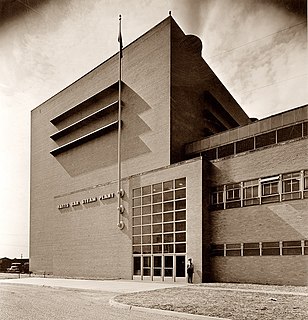
Watts Bar Steam Plant was a 267-megawatt (MW), coal power plant operated by the Tennessee Valley Authority (TVA) located in Rhea County, Tennessee near the present site of Watts Bar Nuclear Plant and Watts Bar Dam. The plant was the first coal-fired power plant constructed by TVA.