Richfield Center, Ohio

Last updated
Former school on Sylvania Avenue Richfield Center former school.jpg
Former school on Sylvania Avenue

Richfield Center is an unincorporated community in Lucas County, in the U.S. state of Ohio. [1]

Lucas County, Ohio county in Ohio, United States

Lucas County is a county located in the U.S. state of Ohio and bordered on the east by Lake Erie, and on the southeast by the Maumee River, which runs to the lake. As of the 2010 census, the population was 441,815. Its county seat is Toledo, located at the mouth of the Maumee River on the lake. The county was named for Robert Lucas, 12th governor of Ohio, in 1835 during his second term. Its establishment provoked the Toledo War conflict with the Michigan Territory, which claimed some of its area.

U.S. state constituent political entity sharing sovereignty as the United States of America

In the United States, a state is a constituent political entity, of which there are currently 50. Bound together in a political union, each state holds governmental jurisdiction over a separate and defined geographic territory and shares its sovereignty with the federal government. Due to this shared sovereignty, Americans are citizens both of the federal republic and of the state in which they reside. State citizenship and residency are flexible, and no government approval is required to move between states, except for persons restricted by certain types of court orders. Four states use the term commonwealth rather than state in their full official names.

Ohio State of the United States of America

Ohio is a Midwestern state in the Great Lakes region of the United States. Of the fifty states, it is the 34th largest by area, the seventh most populous, and the tenth most densely populated. The state's capital and largest city is Columbus.

History

A post office called Richfield Centre was established in 1874, the name was changed to Richfield Center in 1893, and the post office closed in 1901. [2] The community is located in Richfield Township, [3] from which it takes its name. In 1910, Richfield Center had 111 inhabitants. [4]

Richfield Township, Lucas County, Ohio Township in Ohio, United States

Richfield Township is one of the eleven townships of Lucas County, Ohio, United States. The 2010 census found 1,598 people in the township, 1,361 of whom lived in the unincorporated portions of the township.

Related Research Articles

Sylvania, Ohio City in Ohio, United States

Sylvania is a city in Lucas County, Ohio, United States. The population was 18,971 at the 2010 census. Sylvania is a suburb of Toledo. Its northern border is the southern border of the State of Michigan.

Waterville, Ohio City in Ohio, United States

Waterville is a city in Lucas County, Ohio, United States, along the Maumee River, a suburb of Toledo. The population was 5,523 at the 2010 census.

Sylvania Township, Lucas County, Ohio Township in Ohio, United States

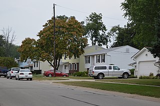
Sylvania Township is one of the eleven townships of Lucas County, Ohio, United States. As of 2010, the total population was 48,487, making it the second most populous county subdivision of Lucas County, Northwest Ohio, and the 419 / 567 area codes. It is the 8th most populous township in Ohio.

Washington Township, Lucas County, Ohio Township in Ohio, United States

Washington Township is one of the eleven townships of Lucas County, Ohio, United States. The 2010 census found 3,278 people in the township.

Toledo metropolitan area Metropolitan area in Ohio, United States

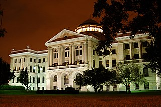
The Toledo, Ohio, metropolitan area is a metropolitan area centered on the American city of Toledo, Ohio. As of the 2010 census, the metropolitan statistical area (MSA) had a population of 651,429. It is the sixth-largest metropolitan area in the state of Ohio, behind Cincinnati–Northern Kentucky, Cleveland, Columbus, Dayton, and Akron.

Rudolph, Ohio Census-designated place in Ohio, United States

Rudolph is an unincorporated community and census-designated place (CDP) in eastern Liberty Township, Wood County, Ohio, United States. As of the 2010 census, it had a population of 458. Although it is unincorporated, it has a post office, with the ZIP code of 43462.

Neapolis, Ohio Census-designated place & Unincorporated community in Ohio, United States

Neapolis is a census-designated place (CDP) in northwestern Providence Township, Lucas County, Ohio, United States. As of the 2010 census it had a population of 423. It has a post office, with the ZIP code of 43547.

Ai, Ohio human settlement in United States of America

Ai is an unincorporated community in Fulton County, Ohio, United States, established around 1843. The origin of its name has been a local controversy: some say that it was named after the biblical city of Ai, while others believe that it was named after one of its founders, Ami Richards. The story continues Ami was a man, so others dropped the 'M' from his name to make the town's name more masculine. Ai has been noted for its short place name.

Fairview, Rush County, Indiana Unincorporated community in Indiana, United States

Fairview is an unincorporated community in Rush and Fayette counties, in the U.S. state of Indiana.

Townwood is an unincorporated community in Putnam County, in the U.S. state of Ohio.

Frankfort is an unincorporated community in Spencer Township, Lucas County, in the U.S. state of Ohio.

Yondota is an unincorporated community in Lucas County, in the U.S. state of Ohio.

Rockaway is an unincorporated community in Seneca County, in the U.S. state of Ohio.

Erlin is an unincorporated community in Sandusky County, in the U.S. state of Ohio.

Portage Center is an unincorporated community in Hancock County, in the U.S. state of Ohio.

Scotts Crossing is an unincorporated community in Allen County, in the U.S. state of Ohio.

Bloom Center is an unincorporated community in Wood County, Ohio.

Galatea is an unincorporated community in Wood County, in the U.S. state of Ohio.

Marengo is an extinct town in Lucas County, in the U.S. state of Ohio.

Fertile is an unincorporated community in Washington County, in the U.S. state of Missouri.

References

Coordinates: 41°41′8″N83°49′4″W / 41.68556°N 83.81778°W / 41.68556; -83.81778

Geographic coordinate system Coordinate system

A geographic coordinate system is a coordinate system that enables every location on Earth to be specified by a set of numbers, letters or symbols. The coordinates are often chosen such that one of the numbers represents a vertical position and two or three of the numbers represent a horizontal position; alternatively, a geographic position may be expressed in a combined three-dimensional Cartesian vector. A common choice of coordinates is latitude, longitude and elevation. To specify a location on a plane requires a map projection.