Richland, Mississippi

Last updated

Richland, Mississippi
City of Richland
Richland Water Tower in Richland,MS.jpg
Richland Water Tower reads "City of Richland, Home of the Rangers"
Motto(s): 
"Proud to Call it Home!", "An Excellent Choice"
Rankin County Mississippi Incorporated and Unincorporated areas Richland Highlighted.svg
Location of Richland, Mississippi
Usa edcp relief location map.png
Red pog.svg
Richland
Location of Richland in the US
Coordinates: 32°13′47″N90°9′35″W / 32.22972°N 90.15972°W / 32.22972; -90.15972
Country Flag of the United States.svg  United States
State Flag of Mississippi.svg  Mississippi
County Rankin
District1
Incorporated [1] October 31, 1974;49 years ago (1974-10-31)
Government
[2]
  Type Mayor–Council
   Mayor Pat Sullivan (I)
   Board of Aldermen Clay Burns
Robert Craft
Beth Sanford
Gus Black
Cathey Wynne
Area
[3]
  Total12.59 sq mi (32.61 km2)
  Land12.53 sq mi (32.44 km2)
  Water0.07 sq mi (0.17 km2)
Elevation
266 ft (81 m)
Population
 (2020)
  Total7,137
  Density569.82/sq mi (220.01/km2)
Time zone UTC-6 (Central (CST))
  Summer (DST) UTC-5 (CDT)
ZIP code(s)
39073, 39208, 39218, 39232
Area code(s) 601
FIPS code 28-62400
GNIS feature ID 690674
Major airport JAN
Website richlandms.org

Richland is a city in Rankin County, Mississippi, United States. The population was 6,912 at the 2010 census. A suburb of Jackson, Richland is part of the Jackson Metropolitan Statistical Area, and is located southeast of the state capital.

Contents

Geography

Richland is located at 32°13′47″N90°9′35″W / 32.22972°N 90.15972°W / 32.22972; -90.15972 (32.229844, -90.159724). [4] According to the United States Census Bureau, the city has a total area of 12.2 square miles (32 km2), of which 12.2 square miles (32 km2) is land and 0.04-square-mile (0.10 km2) (0.16%) is water.

Demographics

Historical population
CensusPop.Note
1980 3,955
1990 4,0141.5%
2000 6,02750.1%
2010 6,91214.7%
2020 7,1373.3%
U.S. Decennial Census [5]

2020 census

Richland racial composition [6]
RaceNum.Perc.
White (non-Hispanic)4,77666.92%
Black or African American (non-Hispanic)1,41919.88%
Native American 30.04%
Asian 1632.28%
Pacific Islander 30.04%
Other/Mixed 1762.47%
Hispanic or Latino 5978.36%

As of the 2020 United States census, there were 7,137 people, 2,645 households, and 1,888 families residing in the city.

2000 census

As of the census [7] of 2000, there were 6,027 people, 2,303 households, and 1,688 families residing in the city. The population density was 492.7 inhabitants per square mile (190.2/km2). There were 2,540 housing units at an average density of 207.6 per square mile (80.2/km2). The racial makeup of the city was 60% White, 40% African American, 0.08% Native American, 1.51% Asian, 0.02% Pacific Islander, 0.20% from other races, and 0.95% from two or more races. Hispanic or Latino of any race were 0.88% of the population.

There were 2,303 households, out of which 37.5% had children under the age of 18 living with them, 54.8% were married couples living together, 13.4% had a female householder with no husband present, and 26.7% were non-families. 21.8% of all households were made up of individuals, and 6.8% had someone living alone who was 65 years of age or older. The average household size was 2.62 and the average family size was 3.05.

In the city, the population was spread out, with 27.3% under the age of 18, 9.8% from 18 to 24, 33.6% from 25 to 44, 20.1% from 45 to 64, and 9.3% who were 65 years of age or older. The median age was 32 years. For every 100 females, there were 98.2 males. For every 100 females age 18 and over, there were 94.0 males.

The median income for a household in the city was $38,996, and the median income for a family was $44,800. Males had a median income of $32,377 versus $22,700 for females. The per capita income for the city was $17,574. About 8.3% of families and 10.4% of the population were below the poverty line, including 11.2% of those under age 18 and 19.8% of those age 65 or over.

Government

The Mayor of Richland is former alderman Pat Sullivan, who is serving his first term.

Education

The three public schools in Richland are operated by the Rankin County School District.

See also

Related Research Articles

<span class="mw-page-title-main">Richland County, Ohio</span> County in Ohio, United States

Richland County is a county located in the U.S. state of Ohio. As of the 2020 census, the population was 124,936. Its county seat is Mansfield. The county was created in 1808 and later organized in 1813. It is named for the fertile soil found there.

<span class="mw-page-title-main">Sharkey County, Mississippi</span> County in Mississippi, United States

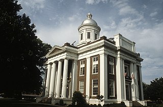
Sharkey County is a county located in the U.S. state of Mississippi. Part of the eastern border is formed by the Yazoo River. According to the 2020 census, the population was 3,800, making it the second-least populous county in Mississippi, after Issaquena County. Its county seat is Rolling Fork. The county is named after William L. Sharkey, the provisional Governor of Mississippi in 1865.

<span class="mw-page-title-main">Madison County, Mississippi</span> County in Mississippi, United States

Madison County is a county located in the U.S. state of Mississippi. As of the 2020 census, the population was 109,145. The county seat is Canton. The county is named for Founding Father and U.S. President James Madison.

<span class="mw-page-title-main">Itawamba County, Mississippi</span> County in Mississippi, United States

Itawamba County is a county located in the U.S. state of Mississippi. As of the 2020 United States Census, the population was 23,863. Its county seat is Fulton. The county is part of the Tupelo, MS Micropolitan Statistical Area.

<span class="mw-page-title-main">Calhoun County, Mississippi</span> County in Mississippi, United States

Calhoun County is a county located in the U.S. state of Mississippi. As of the 2020 census, the population was 13,266. Its county seat is Pittsboro. The county is named after John C. Calhoun, the U.S. Vice President and U.S. Senator from South Carolina.

<span class="mw-page-title-main">Picture Rocks, Arizona</span> CDP in Pima County, Arizona

Picture Rocks is a census-designated place (CDP) in Pima County, Arizona, United States, home of the Tucson artifacts. The population was 9,551 at the 2020 United States census.

<span class="mw-page-title-main">Atlanta, Illinois</span> City in Illinois, United States

Atlanta is a city in Logan County, Illinois, United States. The population was 1,692 at the 2010 census.

<span class="mw-page-title-main">Keithsburg, Illinois</span> City in Illinois, United States

Keithsburg is a city in Mercer County, Illinois, United States, on the Mississippi River. The population was 550 at the 2020 census, down from 609 in 2010. It was named for Robert Keith, a pioneer settler.

<span class="mw-page-title-main">New Boston, Illinois</span> City in Illinois, United States

New Boston is a city in Mercer County, Illinois, United States on the Mississippi River. The population was 613 at the 2020 census, down from 683 in 2010.

<span class="mw-page-title-main">Ellettsville, Indiana</span> Town in Indiana, United States

Ellettsville is a town in Richland Township, Monroe County, Indiana, United States. The population was 6,655 at the 2020 census. It is part of the Bloomington, Indiana Metropolitan Statistical Area. Ellettsville is the starting point for the Hilly Hundred, a two-day bicycle tour.

<span class="mw-page-title-main">Florence, Mississippi</span> City in Mississippi, United States

Florence is a city in Rankin County, Mississippi, United States. As of the 2010 Census, the population was 4,141. It is part of the Jackson Metropolitan Statistical Area.

<span class="mw-page-title-main">Flowood, Mississippi</span> City in Mississippi, United States

Flowood is a city in Rankin County, Mississippi, United States. The population was 10,202 as of the 2020 census. A suburb of Jackson, Flowood is part of the Jackson Metropolitan Statistical Area, and is located northeast of the state capital.

<span class="mw-page-title-main">Pearl, Mississippi</span> City in Mississippi, United States

Pearl is a city in Mississippi, located in Rankin County on the east side of the Pearl River across from the state capital Jackson. The population was 27,115 as of the 2020 census. It is part of the Jackson Metropolitan Statistical Area.

<span class="mw-page-title-main">West Alton, Missouri</span> City in Missouri, United States

West Alton is a city in St. Charles County, Missouri, United States. The population was 359 at the 2020 census. It is located at the tip of the peninsula formed by the confluence of the Missouri and Mississippi Rivers and is directly across Alton, Illinois.

<span class="mw-page-title-main">West Richland, Washington</span> City in Washington, United States

West Richland is a city in Benton County, Washington. The population was 16,295 at the time of the 2020 census. The city is part of the Tri-Cities metropolitan area, whose principal cities are Richland, Kennewick, and Pasco.

<span class="mw-page-title-main">Dayton, Richland County, Wisconsin</span> Town in Wisconsin, United States

Dayton is a town in Richland County, Wisconsin, United States. The population was 763 at the 2020 census. The unincorporated community of Nevels Corners is located in the town. The ghost town of Ashford was also located in the town.

<span class="mw-page-title-main">Westford, Richland County, Wisconsin</span> Town in Wisconsin, United States

Westford is a town in Richland County, Wisconsin, United States. The population was 594 at the 2000 census. The unincorporated communities of Bunker Hill and Germantown are located in the town. The unincorporated community of Corwin was also located in the town.

<span class="mw-page-title-main">Yuba, Wisconsin</span> Village in Wisconsin, United States

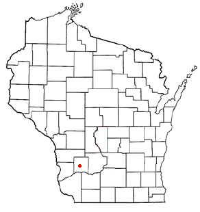
Yuba is a village in Richland County, Wisconsin, United States. The population was 74 at the 2010 census. Yuba is 11 miles southwest of Hillsboro and 17 miles north of Richland Center. County Hwy C runs through the village.

<span class="mw-page-title-main">Richland, Iowa</span> City in Iowa, United States

Richland is a city in Keokuk County, Iowa, United States. The population was 542 at the time of the 2020 census.

<span class="mw-page-title-main">Brandon, Mississippi</span> City in Mississippi, United States

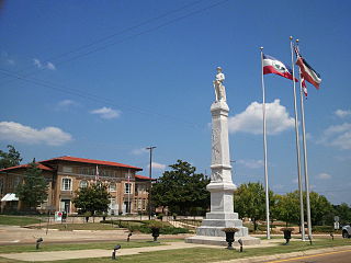
Brandon is a city in and the county seat of Rankin County, Mississippi, United States. It was incorporated on December 19, 1831. The population was 25,138 as of the 2020 census. A suburb of Jackson, Brandon is part of the Jackson Metropolitan Statistical Area, and is located east of the state capital.

References

  1. "City of Jackson and City of Pearl v. Petitioners for Incorporation of the City of Richland". Supreme Court of Mississippi. 1975. Retrieved April 15, 2017 via Leagle.
  2. "City of Richland". Richland, MS. 2016. Retrieved May 12, 2017 via Central Mississippi Planning & Development District.
  3. "2020 U.S. Gazetteer Files". United States Census Bureau. Retrieved July 24, 2022.
  4. "US Gazetteer files: 2010, 2000, and 1990". United States Census Bureau. February 12, 2011. Retrieved April 23, 2011.
  5. "Census of Population and Housing". Census.gov. Retrieved June 4, 2015.
  6. "Explore Census Data". data.census.gov. Retrieved December 16, 2021.
  7. "U.S. Census website". United States Census Bureau . Retrieved January 31, 2008.
Government
General information