Richmond Hill is an area of Bournemouth, Dorset, England. [1] It is to the north of Bournemouth Town Centre, south of Richmond Park and west of Lansdowne. [2] The area is located around the road of the same name.
Richmond Hill is an area of Bournemouth, Dorset, England. [1] It is to the north of Bournemouth Town Centre, south of Richmond Park and west of Lansdowne. [2] The area is located around the road of the same name.
In 2018 and 2019, the road was turned into a temporary waterslide in the summer. [3]
In 2023, Vitality will move into the Nationwide building in Richmond Hill. [4]
In 2024, a police investigation was launched into a suspected brothel in the area. [5]
In 1975, the A338 underpass was built underneath Richmond Hill Roundabout. [8]
The Square is at the bottom of Richmond Hill. [9]
Richmond Hill is part of the Bournemouth Central ward for elections to the Bournemouth, Christchurch and Poole Council. The same ward elected councillors to Bournemouth Borough Council.
Richmond Hill is also part of the Bournemouth West parliamentary constituency for elections to the House of Commons of the United Kingdom.


Dorset is a ceremonial county in South West England. It is bordered by Somerset to the north-west, Wiltshire to the north and the north-east, Hampshire to the east, the Isle of Wight across the Solent to the south-east, the English Channel to the south, and Devon to the west. The largest settlement is Bournemouth, and the county town is Dorchester.

Bournemouth is a coastal resort town on the south coast in the Bournemouth, Christchurch and Poole unitary authority area in the ceremonial county of Dorset, England. The town's urban subdivision had a population of 187,503 at the 2011 census making it the largest town in the county; the town is part of the South East Dorset conurbation, which has a population of 465,000.

The A35 is a major road in southern England, connecting Honiton in Devon and Southampton in Hampshire. It is a trunk road for some of its length. Most of its route passes through Dorset and the New Forest. It originally connected Exeter and Southampton, the original A35 ran along what is now the A3052 joining the present road at Charmouth.

Branksome is a suburb of Poole, in the Bournemouth, Christchurch and Poole district, in the ceremonial county of Dorset, England. The area consists of residential properties and also a number of commercial and industrial areas.

The A338 is a major primary route in southern England, that runs from the junction with the A35 at Poole in Dorset to the junction with the A420 at Besselsleigh in Oxfordshire, a distance of 84 miles (135 km).

Holdenhurst is a small isolated village situated in the green belt land of the north-east suburbs of Bournemouth, England. The village comprises fewer than 30 dwellings, two farms and the parish church. There are no shops and few local facilities in the village.

Parkstone is an area of Poole, in the Bournemouth, Christchurch and Poole district, in the ceremonial county of Dorset, England. It is divided into 'Lower' and 'Upper' Parkstone. Upper Parkstone - "Up-on-'ill" as it used to be known in local parlance - is so-called because it is largely on higher ground slightly to the north of the lower-lying area of Lower Parkstone - "The Village" - which includes areas adjacent to Poole Harbour.

Springbourne is a suburb of Bournemouth in Dorset, England. It occupies the north-east part of the main built-up area, north of Boscombe. Its formal boundaries are Northcote Road to the west, the Wessex Way (A338) to the north, Ashley Road to the east, and the railway line to the south.

Dorset is a county in South West England. The county is largely rural and therefore does not have a dense transport network, and is one of the few English counties without a motorway. Owing to its position on the English Channel coast, and its natural sheltered harbours, it has a maritime history, though lack of inland transport routes have led to the decline of its ports.
Winton is a suburb of Bournemouth, in the Bournemouth, Christchurch and Poole district, in the ceremonial county of Dorset, England. It lies approximately 1 mile (1.6 km) north of Bournemouth town centre, along Wimborne Road. Winton is to the east of Wallisdown, Victoria Park and Talbot Woods and south of Moordown.
The Bournemouth Daily Echo, commonly known as the Daily Echo, is a local newspaper that covers the area of southeast Dorset, England, including the towns Poole, Bournemouth and Christchurch. Published by Newsquest (Southern) Limited, issues appear Monday to Saturday, and has an average daily circulation of 9,589 in January to June 2020.

The Royal Bournemouth Hospital is an acute general hospital in Bournemouth, Dorset, England. It is managed by the University Hospitals Dorset NHS Foundation Trust. The hospital was managed by The Royal Bournemouth and Christchurch Hospitals NHS Foundation Trust until the merger with Poole Hospital NHS Foundation Trust on 1 October 2020.

Bournemouth, Christchurch and Poole (BCP) is a unitary authority area in the ceremonial county of Dorset, England. It was created on 1 April 2019 by the merger of the areas that were previously administered by the unitary authorities of Bournemouth and Poole, and the non-metropolitan district of Christchurch. The authority covers much of the area of the South Dorset conurbation.

Strouden Park or Strouden is an area of Bournemouth, Dorset, England.

Bournemouth Town Centre is an area of Bournemouth, Dorset. The town centre is the central business district and is located near the coast between West Cliff and East Cliff.

Bournemouth Town Hall is a municipal facility in Bourne Road, Bournemouth, England. The town hall, which is the meeting place of Bournemouth, Christchurch and Poole Council, is a Grade II listed building. The town hall stands opposite Bournemouth Gardens and the Bournemouth War Memorial and is adjacent to St. Andrew's Church, Richmond Hill.

Richmond Park is an area of Bournemouth, Dorset, England. The area is north of Richmond Hill and Springbourne, east of Charminster, west of Queen's Park and south of Winton and Queen's Park.

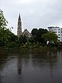
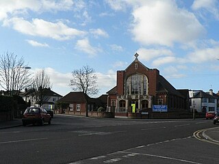
St. Andrew's Church is a Grade II listed Gothic Victorian church in Richmond Hill, Bournemouth, Dorset, England. A United Reformed church, it is noted for being the largest church in the town.

The Bournemouth Blitz was the heavy bombing of Bournemouth, Hampshire, England from 1940 to 1944, by the Nazi German Luftwaffe during the Second World War.
Negro
| | This Dorset location article is a stub. You can help Wikipedia by expanding it. |