Ichtegem is a municipality located in the Belgian province of West Flanders 15 km southwest of Bruges. The municipality comprises the towns of Bekegem, Eernegem and Ichtegem proper. On January 1, 2006 Ichtegem had a total population of 13,423. The total area is 45.33 km² which gives a population density of 296 inhabitants per km². The current mayor is Karl Bonny.

Lichtervelde is a municipality located in the Belgian province of West Flanders. The municipality comprises only the town of Lichtervelde. On January 1, 2006 Lichtervelde had a total population of 8,400. The total area is 25.93 km² which gives a population density of 324 inhabitants per km². The church is 64 m high. In this town the inventor Charles Joseph Van Depoele was born.

Oostrozebeke is a municipality located in the Belgian province of West Flanders. The municipality comprises only the town of Oostrozebeke proper. On January 1, 2018 Oostrozebeke had a total population of 7,849. The total area is 16.62 km² which gives a population density of 472 inhabitants per km².

Hamme is a municipality located in the Belgian province of East Flanders. The municipality comprises the towns of Hamme proper, Kastel Moerzeke, Sint-Anna and Zogge. In 2018, Hamme had a total population of 24,827. The total area is 40.21 km². The current mayor of Hamme is Herman Vijt, from the CD&V party.

Laarne is a municipality located in the Belgian province of East Flanders. The municipality comprises the towns of Kalken and Laarne proper. On 1 January 2018, Laarne had a total population of 12,487. The total area is 32.07 km². The current mayor of Laarne is Ignace De Baerdemaecker, from the VLD (Liberal) party.

Zele is a municipality located in the Belgian province of East Flanders, around 20 km east of Ghent. The municipality only comprises the town of Zele proper. In 2021, Zele had a total population of 21,333. The total area is 33.06 km2 which gives a population density.

Gavere is a municipality located in the Belgian province of East Flanders. The municipality comprises the towns of Asper, Baaigem, Dikkelvenne, Gavere, Semmerzake and Vurste. In 2021, Gavere had a total population of 13,007. The total area is 31.35 km².

Oosterzele is a municipality located in the Flemish province of East Flanders, in Belgium. The municipality comprises the towns of Balegem, Gijzenzele, Landskouter, Moortsele, Oosterzele proper and Scheldewindeke. In 2021, Oosterzele had a total population of 13,740. The total area is 43.12 km². Its twin town is Oberkirch in Germany.

Sint-Martens-Latem is a municipality located in the Belgian province of East Flanders, in Belgium. The municipality comprises the towns of Deurle and Sint-Martens-Latem proper. In 2021, Sint-Martens-Latem had a total population of 8,285. The total area is 14.34 km².

Wachtebeke is a municipality located in the Belgian province of East Flanders. The municipality comprises the town of Wachtebeke proper, and a smaller town: Overslag. In 2021, Wachtebeke had a total population of 7.769. The total area is 34.53 km2.

Horebeke is a municipality located in the Belgian province of East Flanders. The municipality comprises the towns of Sint-Kornelis-Horebeke and Sint-Maria-Horebeke. On 1 January 2018, Horebeke had a total population of 2,048. The total area is 11.20 km² .

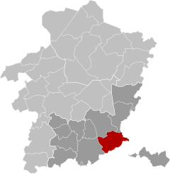
Lierde is a municipality located in the Flemish Ardennes, the hilly southern part of the Belgian province of East Flanders in the Denderstreek. The municipality comprises the towns of Deftinge, Hemelveerdegem, Sint-Maria-Lierde and Sint-Martens-Lierde. In 2021, Lierde had a total population of 6,626. The total area is 26.13 km². Lierde borders to Brakel, Zottegem, Herzele and Geraardsbergen. Lierde is known for the Ronde van vlaanderen, a bike race where cyclists climb all the hills of the Flemish Ardennes.

Putte is a municipality located in the Belgian province of Antwerp. The municipality includes the towns of Putte, Beerzel, and the hamlets Grasheide and Peulis. The town of Putte is around 8 kilometres (5.0 mi) east of Mechelen. In 2021, Putte had a total population of 18,109. The total area is 34.96 km2.

Willebroek is a municipality located in the Belgian province of Antwerp. The municipality comprises the towns of Blaasveld, Heindonk, Tisselt, Klein Willebroek, and Willebroek proper. In 2021, Willebroek had a total population of 27,081. The total area is 27.41 km².
Arendonk is a municipality located in the Belgian province of Antwerp. The municipality comprises only the town of Arendonk proper. In 2021, Arendonk had a total population of 13,207. The total area is 55.38 km².

Retie is a municipality located in the Campine region of the province of Antwerp, Belgium. The municipality comprises the town of Retie proper and several hamlets of which Schoonbroek is the largest. In 2021, Retie had a total population of 11,582. The total area is 48.39 km2.

Vorselaar is a municipality located in the Belgian province of Antwerp. The municipality comprises only the town of Vorselaar proper. In 2021, Vorselaar had a total population of 7,995. The total area is 27.62 km2.

Westerlo is a municipality located in the Belgian province of Antwerp. The municipality comprises seven towns:

Begijnendijk is a municipality located in the Belgian province of Flemish Brabant. The municipality comprises the towns of Begijnendijk proper and Betekom. On January 1, 2006, Begijnendijk had a total population of 9,400. The total area is 17.62 km² which gives a population density of 534 inhabitants per km². The official spoken language is Dutch.
Plombières is a municipality of Wallonia located in the province of Liège, Belgium.