| Cairo Ring Road | |
|---|---|
| Location | |
| Country | Egypt |
| Highway system | |
The Cairo Ring Road is a 100km long ring road that encircles most of the contiguous metropolitan area of the cities of Cairo, Giza and Shubra Al-Kheima, in the Greater Cairo region in Egypt.
Construction began in the late 1980s. It was originally planned to surround the Greater Cairo region from three of its four sides, [1] but part of the road remains unbuilt because the original route took it very near the Giza pyramids, an area which has been on the UNESCO's World Heritage List since 1979. [2] It had two purposes: stopping the urbanization of arable lands, and reducing Cairo's traffic.
In the early 2000s, planning for a regional ring road commenced, enclosing the larger metropolitan area including El Shorouk, New Cairo and Helwan in the Cairo Governorate, Obour in the Qalyubiyya Governorate and 6th of October in the Giza Governorate, which was completed in 2018.
There were three master plans for the urban development of Cairo, in 1956, 1970 and 1983. The Ring Road first appeared in the second plan as a beltway encompassing the eastern (Cairo) sector of the Greater Cairo region, [3] and linking all the 16 administrative regions that the plan created. [3] In the third master plan, approved in 1984 under the government of Hosni Mubarak and in collaboration with France, it appeared as a 73 km (45 mi) long beltway. [1] [3] It would connect the new 16 administrative regions of the city and would isolate them from the rural areas. [3]
It was left unfinished due to part of the road passing too near the Pyramids of Giza (see other section in this article). The Egyptian government planned to close it by building a road over the Marioteya waterway. [4] [5]
Ring Road had the main purpose of stopping the urbanization of arable lands by creating a barrier around the Greater Cairo region. [3] [6] It was unsuccessful, with the urbanization tripling in amount and the remaining arable land inside the perimeter being to all effects condemned to urbanization. [6] There were also negative effects, like settlements being cut in two parts, with the outer part getting isolated. [6] It also helped rich people create luxury urbanizations outside of the main city nucleus, following the example of American cities like Los Angeles and straying away from the European model of compact cities. [7]
A secondary purpose was to reduce the traffic inside the city. [6]
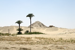
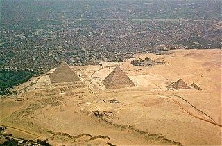
Ring Road's original route in 1984 took it very near the Giza pyramids, an area which has been on the UNESCO's World Heritage List since 1979. In 1994, The Independent alerted the world [8] that the construction was probably destroying ancient burial sites since no proper controls were made. [9] Also, it would pass by the South of the Giza plateau, isolating it from the open desert by surrounding it with roads on its four sides and bringing enormous urbanistical pressure. [9] The UNESCO pressured the Egyptian government, causing in 1995 the halting of the construction of that part of the road. [2] A UNESCO committee recommended in 1995 to by follow the Mariutiya Canal or the El Mansuriya Canal, thus passing the road North of the plateau. [10] In 2002 there were discussions about building an underpass or a tunnel. [11]
The total length of the ring road in 2001 was about 72 km (45 mi) [12] with more than 50% on desert land, 15% in urbanized area, and 35% on arable land. [13] The highway has eight lanes. The total budget for the project was E£3 billion. [4] [13]
The ring road connects to the Cairo–Alexandria highway, near the pyramids at Giza. [14]
Second and third ring roads have been proposed for Cairo. [15]
In 2010, a report commissioned by the World Bank and the government of Egypt found that the city was still severely congestioned, and identified many problematic spots, many of them on the Ring Road. [16]
In 2013, The Cairo Post said that lack of public transport, bad design and lack of maintenance have caused the road to be congested and a "death trap" for drivers. For example, the entries and exits are too narrow, they are in bad state, they transition too abruptly from sandy roads, they are in bad state or covered with sand, there are too few of them and people have to travel long distances through bad roads to reach the nearest entry. It's a problem for pedestrians because there are no sideways, no pedestrian crossings, no pedestrian bridges, and no protected sideways for people who are waiting for public transportation. [17]

Cairo is the capital of Egypt and the city-state Cairo Governorate, and is the country's largest city, home to 10 million people. It is also part of the largest urban agglomeration in Africa, the Arab world and the Middle East, the Greater Cairo metropolitan area, which is the 12th-largest in the world by population with a population of over 22.1 million.

Giza is the third-largest city in Egypt by area after Cairo and Alexandria; and fourth-largest city in Africa by population after Kinshasa, Lagos, and Cairo. It is the capital of Giza Governorate with a total population of 4,872,448 in the 2017 census. It is located on the west bank of the Nile opposite central Cairo, and is a part of the Greater Cairo metropolis. Giza lies less than 30 km (18.64 mi) north of Memphis, which was the capital city of the unified Egyptian state during the reign of pharaoh Narmer, roughly 3100 BC.
Giza Governorate is one of the governorates of Egypt. It is in the center of the country, situated on the west bank of the Nile River opposite Cairo. Its capital is the city of Giza. It includes a stretch of the left bank of the Nile Valley around Giza, and acquired a large stretch of Egypt's Western Desert, including Bahariya Oasis when the 6th of October Governorate was merged into it on 14 April 2011. The Giza Governorate is also home to the Great Sphinx and the Pyramids of Giza.

Beheira Governorate is a coastal governorate in Egypt. Located in the northern part of the country in the Nile Delta, its capital is Damanhur.

Qalyubia Governorate is one of the governorates of Egypt. Located in Lower Egypt. It is situated north of Cairo in the Nile Delta region. Its capital is Banha.

The Giza pyramid complex in Egypt is home to the Great Pyramid, the Pyramid of Khafre, and the Pyramid of Menkaure, along with their associated pyramid complexes and the Great Sphinx. All were built during the Fourth Dynasty of the Old Kingdom of ancient Egypt, between c. 2600 – c. 2500 BC. The site also includes several temples, cemeteries, and the remains of a workers' village.

Helwan is a suburban district in the Southern Area of Cairo, Egypt. The area of Helwan witnessed prehistoric, ancient Egyptian, Roman and Muslim era activity. More recently it was designated as a city until as late as the 1960s, before it became contiguous with the city of Cairo and was incorporated as a district. For a brief period between April 2008 and April 2011 it was redesignated as a city, and served as the capital of the now defunct Helwan Governorate that was split from Cairo and Giza governorates, before being re-incorporated back into them. The kism of Helwan had a population of 521,239 in the 2017 census.
Imbaba is a working-class neighbourhood in northern Giza, Egypt, located west of the Nile and northwest of and near Gezira Island and downtown Cairo, within the Giza Governorate. The district is located in the historic upper Nile Delta, and is part of the Greater Cairo metropolitan area. Imbaba is the most densely populated city subdivision in the world.
6th of October is a city in the Giza Governorate of Egypt. It is a satellite city, located adjacent to Giza, and is part of the Greater Cairo region. Per the 2017 national census, it had a population of 450,000 people.

The Greater Cairo Region is a metropolitan area centered around Cairo, Egypt. It comprises the entirety of the Cairo Governorate, the cities of Imbaba and Giza in the Giza Governorate, and the city Shubra El Kheima in Qalyubia Governorate. Its definition can be expanded to include peri-urban areas and a number of new planned towns founded in the desert areas east and west of Cairo. The Greater Cairo Region is also officially defined as an economic region consisting of the Cairo, Giza, and Qalyubia Governorates. Within Greater Cairo lies the largest metropolitan area in Egypt, the largest urban area in Africa, the Middle East, and the Arab world, and the 6th largest metropolitan area in the world.

Egypt is divided, for the purpose of public administration, according to a three-layer hierarchy and some districts are further subdivided, creating an occasional fourth layer. It has a centralized system of local government officially called local administration as it is a branch of the Executive.

Presidential Decree 495/1977 divided Egypt into eight economic regions for economic and physical planning purposes, that do not have any new administrative representation in the local government hierarchy.

Sheikh Zayed City is a city in Giza Governorate in Egypt and part of the Greater Cairo urban area. It was established in 1995 and is named after Zayed bin Sultan Al Nahyan.
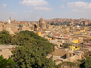
The City of the Dead, or Cairo Necropolis, also referred to as theQarafa, is a series of vast Islamic-era necropolises and cemeteries in Cairo, Egypt. They extend to the north and to the south of the Cairo Citadel, below the Mokattam Hills and outside the historic city walls, covering an area roughly 4 miles (6.4 km) long. They are included in the UNESCO World Heritage Site of "Historic Cairo".

Egyptian National Police or ENP is a department of the Ministry of Interior of Egypt.

Egypt's environmental problems include, but are not limited to, water scarcity, air pollution, damage to historic monuments, animal welfare issues and deficiencies in its waste management system.
The Western Desert of Egypt is an area of the Sahara that lies west of the river Nile, up to the Libyan border, and south from the Mediterranean Sea to the border with Sudan. It is named in contrast to the Eastern Desert which extends east from the Nile to the Red Sea. The Western Desert is mostly rocky desert, though an area of sandy desert, known as the Great Sand Sea, lies to the west against the Libyan border. The desert covers an area of 680,650 km2 (262,800 sq mi) which is two-thirds of the land area of the country. Its highest elevation is 1,000 m (3,300 ft) in the Gilf Kebir plateau to the far south-west of the country, on the Egypt-Sudan-Libya border. The Western Desert is barren and uninhabited save for a chain of oases which extend in an arc from Siwa, in the north-west, to Kharga in the south. It has been the scene of conflict in modern times, particularly during the Second World War.

The following outline is provided as an overview of and topical guide to Cairo:
El Saff is a city in the Giza Governorate, Egypt. Its population was estimated at 59,000 people in 2018.
El Ayyat is a city in the Giza Governorate, Egypt. Its population was estimated at 44,000 people in 2018.
A third master plan was prepared in 1983. (...) It envisaged the completion of the beltway, or "Ring Road", which would encircle the urban area along only three-fourths of its circumference (73 kilometers) so as not to encourage the urban development of agricultural zones.
Connecting all of these new areas, away from areas of arable land, is a seventy-three-kilometer automotive beltway, called the Ring Road.
Implementing the connection of the eastern and western arcs of the ring road (El Maroteya axes). It will be finished through 24 months.