The Arctic Archipelago, also known as the Canadian Arctic Archipelago, groups together all islands lying to the north of the Canadian continental mainland excluding Greenland.

Coyaima is a town and municipality in the Tolima department of Colombia. The population of the municipality was 27,733 as of the 2005 census.

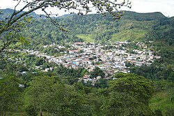
Tarso is a town and municipality in Antioquia Department, Colombia. It lies in the subregion of Southwestern Antioquia.

Tasiusaq is an island settlement in the Avannaata municipality in northwestern Greenland. It had 252 inhabitants in 2020. In Kalaallisut, the name means "looks like a lake".
Innaarsuit is an island settlement in the Avannaata municipality in northwestern Greenland. Located on an island of the same name, the settlement had 180 inhabitants in 2020.
Naajaat is a settlement in the Qaasuitsup municipality in northwestern Greenland. Former spellings include Naujât, Naujat, and Naajat. Located on a small island of the same name, the settlement has 49 inhabitants as of 2020.
Kangersuatsiaq, formerly Prøven, is an island settlement in the Avannaata municipality in northwestern Greenland. It had 130 inhabitants in 2020.

Juan de Acosta is a municipality and town in the Colombian department of Atlántico.

Caimito is a town and municipality located in the Sucre Department, northern Colombia.
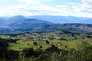
Tópaga is a town and municipality in the Sugamuxi Province, part of the Colombian department of Boyacá. Tópaga is situated on the Altiplano Cundiboyacense with the urban center at an altitude of 2,900 metres (9,500 ft) while the topography varies over the municipality from 2,400 metres (7,900 ft) to 3,200 metres (10,500 ft). It borders Nobsa and Corrales in the west, in the east Mongua and Gámeza, in the north Gámeza and in the south Monguí and Sogamoso. Department capital Tunja is 98 kilometres (61 mi) away. Chicamocha River flows through Tópaga.

Cabañes de Esgueva is a municipality located in the province of Burgos, Castile and León, Spain. According to the 2004 census (INE), the municipality has a population of 243 inhabitants.

Frandovínez is a municipality located in the province of Burgos, Castile and León, Spain. According to the 2004 census (INE), the municipality has a population of 92 inhabitants.

Oquillas is a municipality and town located in the province of Burgos, Castile and León, Spain. According to the 2004 census (INE), the municipality has a population of 74 inhabitants.

Terradillos de Esgueva is a municipality and town located in the province of Burgos, Castile and León, Spain. According to the 2004 census (INE), the municipality has a population of 127 inhabitants.
Torresandino is a municipality and town located in the province of Burgos, Castile and León, Spain. According to the 2004 census (INE), the municipality has a population of 808 inhabitants.

Castrojimeno is a municipality located in the province of Segovia, Castile and León, Spain. According to the 2004 census (INE), the municipality has a population of 38 inhabitants. it's one of the most important geosites in Segovia

Valle de Tabladillo is a municipality located in the province of Segovia, Castile and León, Spain. According to the 2004 census (INE), the municipality has a population of 151 inhabitants.
Espejón is a municipality located in the province of Soria, Castile and León, Spain. According to the 2004 census (INE), the municipality has a population of 209 inhabitants.
Aappilattoq is a settlement in the Avannaata municipality in northwestern Greenland, located on an island of the same name in the southern part of Upernavik Archipelago. Founded in 1805, the settlement had 149 inhabitants in 2020.

Torremocha de Jarama is a municipality of the Community of Madrid, Spain.