U.S. Route 70 or U.S. Highway 70 is an east–west United States highway that runs for 2,381 miles (3,832 km) from eastern North Carolina to east-central Arizona. It is a major east–west highway of the Southeastern, Southern and Southwestern United States. It formerly ran from coast to coast, with the current Eastern terminus near the Atlantic Ocean in Atlantic, North Carolina, and the former Western terminus near the Pacific Ocean in Los Angeles, California. The current Western terminus is at US 60 / SR 77 in Globe, Arizona. Before the completion of the Interstate system, U.S. Highway 70 was sometimes referred to as the "Broadway of America", due to its status as one of the main east–west thoroughfares in the nation. It was also promoted as the "Treasure Trail" by the U.S. Highway 70 Association as of 1951.

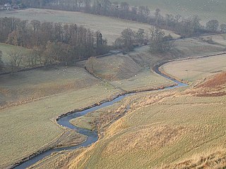
The River Esk, also known as the Border Esk, is a river in Dumfries and Galloway, Scotland, that enters the English county of Cumbria and flows into the Solway Firth.
U.S. Route 9W (US 9W) is a north–south U.S. Highway in the states of New Jersey and New York. It begins in Fort Lee, New Jersey, as Fletcher Avenue crosses the US 1–9, US 46, and the Interstate 95 (I-95) approaches to the George Washington Bridge, and heads north up the west side of the Hudson River to US 9 in Albany, New York. As its "W" suffix indicates, US 9W is a westerly alternate route of US 9 between the two locations. US 9W directly serves three cities—Newburgh, Kingston, and Albany—and enters the vicinity of several others. As the route heads north, it connects to several highways of regional importance, including I-84, US 209, New York State Route 23 (NY 23), and US 20. Much of US 9W parallels the New York State Thruway and NY 32; additionally, the latter overlaps with US 9W in four different locations.
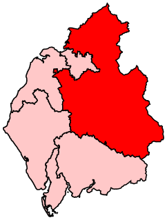
Penrith and The Border is a constituency in Cumbria represented in the House of Commons of the UK Parliament since 2019 by Neil Hudson, a Conservative.

The Bafing River is the upper course and largest tributary of the Senegal River which runs through Guinea and Mali and is about 350 miles (560 km) long.

Highway 17 is a highway in Canada that straddles and criss-crosses the Alberta–Saskatchewan provincial border. The portion from the provincial border at Dillberry Lake Provincial Park to the provincial border 800 metres (2,600 ft) north of the North Saskatchewan River is designated as Alberta Provincial Highway No. 17 by Alberta Transportation, commonly referred to as Highway 17.

The River Irt is a river in the county of Cumbria in northern England. It flows for 14 miles (22 km) from the south-western end of Wast Water, the deepest lake in England, leaving the lake at the foot of Whin Rigg, the southern peak of the famous Wastwater Screes. The name of the river is believed to derive either from the Old English gyr which means "mud", or from the Brittonic words *ar, "flowing", or *īr, "fresh, clean, pure", suffixed with -ed, a nominal suffix meaning "having the quality of...".

The Suchiate River is a river that marks the southwesternmost part of the border between Mexico and Guatemala. From its sources on the southern slopes of the Tacaná volcano in the Sierra Madre range of Guatemala, the river flows in a south-southwesterly direction to the border with Mexico at Unión Juárez, past the border towns Talismán and El Carmen, and then Ciudad Tecún Umán and Ciudad Hidalgo (Chiapas) further downstream, where the Puente Rodolfo Robles and a railway bridge cross the river, and on to the Pacific Ocean. Its name comes from the Nahuatl name Xochiatl meaning "flower-water".
State Trunk Highway 77 is a state highway in the U.S. state of Wisconsin. It runs east–west in northwest Wisconsin from the Minnesota border near Danbury to the Michigan border in Hurley. The highway was first designated in 1920 and was extended to the current routing sometime between 1948 and 1956.

The Whinlatter Pass is a mountain pass in the English Lake District. It is located on the B5292 road linking Braithwaite, to the west of Keswick, with High Lorton to the south of Cockermouth.
The Lyne Water is a tributary of the River Tweed which rises in the Pentland Hills of southern Scotland at Baddinsgill Reservoir. It runs through West Linton and Romannobridge, passes Flemington and Lyne Station and enters the Tweed west of Peebles. It floods regularly in winter and occasionally in summer. There is free fishing above Flemington Bridge, and below Flemington fishing in the river is administered by the Peebles fishing authority.

Hugh Seat is a mountain, or more accurately a fell, in Mallerstang on the eastern edge of Cumbria, England. It lies on the border between Cumbria and North Yorkshire.
Chennault is an unincorporated community in Lincoln County, Georgia, United States. It lies at the intersection of State Routes 44 and 79, to the northwest of the city of Lincolnton, the county seat of Lincoln County. Its elevation is 466 feet (142 m), and it is located at 33°54′27″N82°36′07″W.
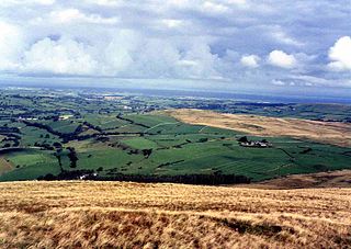
The Solway Plain or Solway Basin is a coastal plain located mostly in northwest Cumbria in England, extending just over the Scottish border to the low-lying area around Gretna and Annan. It lies generally north and west of Carlisle along the Solway Firth, and is drained by the rivers Esk and Lyne. It is associated with the westernmost part of Hadrian's Wall. In medieval times, clay houses known as dabbins were commonly built on the Solway Plain. The Solway coast has been designated an “Area of Outstanding Natural Beauty”.
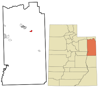
Jensen is a census-designated place in eastern Uintah County, Utah, United States. The population was 412 at the 2010 census. It lies along the Green River and U.S. Route 40, southeast of the city of Vernal, the county seat of Uintah County, and about 17 miles west of the Colorado border. Although Jensen is unincorporated, it has a post office, with the ZIP code of 84035.
U.S. Route 70 enters the state of Tennessee from Arkansas via the Memphis & Arkansas Bridge in Memphis, and runs west to east across 21 counties in all three grand divisions of Tennessee, with a total length of 478.48 miles (770.04 km), to end at the North Carolina state line in eastern Cocke County. Along the route, US 70 is accompanied with various U.S. and state highways, including those in three of the state's four major cities.

The Inírida is a river in the north-west of South America, in the territory of Colombia, the largest tributary of the Guaviare.
Calumet is an unincorporated community in Knox Township, Jefferson County, Ohio, United States. It is located just north of Toronto between Ohio State Route 7 and the Ohio River, at 40°28′55″N80°36′24″W. North 4th Street and North River Avenue both run continuously from Toronto to Calumet.

Kirklinton Middle is a civil parish in City of Carlisle district, Cumbria, England. At the 2011 census it had a population of 384.
Horeb is an unincorporated community in Jefferson Township, Jackson County, Ohio, United States. It is located west of Oak Hill on Ohio State Route 279, at 38°54′12″N82°36′44″W.
