Roads in North Korea are classified into seven levels: motorways, and roads from level 1 to 6. Roads are the secondary means of transport in North Korea, after rail transport. The road network is underdeveloped. Roads are generally in poor condition, are little used and only a small part of the network is paved.
The development of the road network in North Korea began after the Korean War (1950-1953).[1]
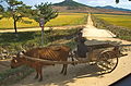
The road network is divided into three main routes: east coast, west coast and east-west link.[2] The low financial resources and the mountainous terrain have placed severe constraints on the development of the road system.[1] Roads are generally underdeveloped, due to restrictions on travel,[3] fuel problems and the near-absence of private cars.[4]
Road construction
The roads were restored in the 1950s after being damaged during the Korean War,[2] then the 1960s saw the creation of paved roads around the centre of Pyongyang.[2] In the 1970s many expressways were built, followed by the 1980s when a network for Tourist Transport emerged, the 1990s continued this policy and added roads for the country's Special Economic Zones.[2]
Road construction in North Korea. The blue truck in the foreground is a Chinese Dongfeng Motors truck.
The leader Kim Il-sung announced that: "The purpose of the roads was to solve the problem of traffic in remote mountain areas and to enable agricultural equipment to reach cultivated land. But roads must not be built on cultivated land. It is totally unacceptable to turn farmland into a road".[5]
Students have been involved in road construction projects since the 1960s.[6] Kim Il-sung took part in the widening of a road between the centre of Pyongyang and a district to the north-east of the capital, a distance of around 16 kilometres.[6] This experience was then presented by Kim Il-sung as a model for student participation in construction projects.[6]
For the construction of the Pyongyang–Nampo Motorway, North Korea mobilised the population on a massive scale, calling on students, office workers and labourers to take part.[5] Much of the work was carried out by hand.[5]
Members of the Workers' Party, workers and the army build and maintain the roads.[2]
Class 5 and 6 roads are maintained by cooperative farms and state-run farms. In addition, the entire population is mobilised two weeks a year, during "road lovers' week", and takes part in road maintenance.[2]
Classification system
In 1949, a regulation on the management of roads established the creation of 5 categories for roads: expressways and other roads with levels from 1 to 4.[2]
On 10 February 1964, the 4-level system was reformed into 6 levels, to improve the organisation of road management and maintenance.[2]·.[7] Since 1964, roads in North Korea have been divided into seven categories: motorways and six levels of general roads.[5]·[2]·.[7]
Composition of the roadbed: shoulders + carriageway.
Road characteristics
North Korea's road network has been shaped by the strong geographical constraints and topographical features of its territory.[1]
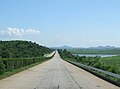
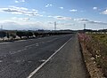
Generally speaking, main roads have two lanes or less,[8] they are not smooth and have many potholes.[5] Road quality is poor.[5] Infrastructures such as bridges and tunnels are highly exposed to the risk of flooding, and bridges are sometimes washed away.[5] Road safety infrastructure is lacking.[5]
The general level 1 roads are not paved and have no sewers or street lighting.[5]
It is difficult for cars to pass each other on general roads, as the carriageway is 3 metres wide, so if two cars pass each other, there are only 15 centimetres on each side.[5]
Roads in North Korea in 2020s will be comparable to South Korean roads in the 1970s.[5]
Number of kilometres and paving
There is a lack of accurate and reliable data on the extent and surfacing of roads in North Korea.[2] This leads to discrepancies between the various figures used by researchers on the subject.[2]
In 1988, North Korea announced that its road infrastructure was 75,500km long.[5] The South Koreans, applying their standards, estimated this network at between 25,000 and 30,000km.[5] In fact, the North Koreans include farm roads in this calculation, which is excluded by the South Koreans.[5]
In 1999, the road network was estimated at around 31,200km[8] of which 1717km are paved.[6]
In 2019, according to Statistics Korea, there were 26,180km of roads, or 23% of the South Korean road network.[5] Excluding motorways, 10% of roads are paved.[5]
Role in transport
The road infrastructure is poorly developed in North Korea.[5] Roads have a secondary, supporting role compared to rail transport.[5]·[1]
Motorways
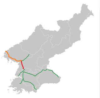
Map of motorways in North Korea in 2014.
North Korea has six motorways stretching 660km,[5] including three major multi-lane motorways:
the Pyongyang-Wonsan Motorway, a 196km four-lane expressway, opened in 1978, linking Pyongyang and Wonsan.
The Pyongyang-Nampo Motorway, a 43km four-lane expressway between Pyongyang and Nampo, opened in 2000.
the Pyongyang-Kaesong motorway, a 100km four-lane motorway linking Pyongyang and Kaesong, opened in 1992.
The country's first motorway, the Pyongyang-Nampo Motorway, was built in 1978. The first tolls were installed on the Pyongyang-Wonsan motorway in 2018.[5]
The Asian Highways (AH) are a cooperative road project in Asia led by the United Nations Economic Commission for Asia and the Pacific (UNESCAP), formalised on 18 November 2003.[11]
The sections of motorway from Sinuiju to Kaesong are part of Asian Highway 1 (AH1).[6]
Roads AH1, AH6 and AH32 pass through North Korea[1]·,[11] this network covers 1,320km of the country[3]·.[11]
Kosong – Wonsan (– Pyongyang) – Chongjin – Sonbong – Khasan – Border with Russia
855
AH32
Sonbong – Wongjong
60
Car transport
Car transport is restricted by a series of regulations. According to North Korean exile Kim Ji-ho, unless a civilian driver receives a special permit, it is forbidden to drive alone (the driver must carry passengers).[12] Other civilian permits are:
a military mobilisation permit (for transporting soldiers in wartime).
a driver training certificate (to be renewed annually)
a fuel validity document (a certificate confirming that the fuel has been purchased from an authorised source), and
a mechanical certificate (to prove that the car is roadworthy).[12]
Since 2017, electric bicycles have become popular in Pyongyang; around 5% of bicycles are electric. Locally produced e-bikes and Chinese e-bikes were available.[13]
Road signs in North Korea
Stop sign.
Since 1945/1946, traffic has travelled on the right on roads[citation needed]. In towns, the speed of traffic is determined by the lane in which the driver is driving.[14]
The red circle signs with the number inside indicate the speed limits. On motorways, the usual limit is 80km/h and 100km/h for the right-hand lanes. The rightmost lane of a motorway is sometimes, as on the Pyongyang-Myohyang motorway, limited to 60km/h near the junctions of the slip roads.
Outside Pyongyang, roundabouts are often used at busy intersections.[15]
North Korean law prohibits walking or cycling on motorways.[5] Motorway traffic is restricted to authorised vehicles, which include military vehicles, intercity buses, emergency transport vehicles and vehicles carrying residents visiting revolutionary sites or foreign tourists.[5]
Cooperation between North and South Korea in the field of road infrastructure is regularly discussed. These often involve road projects linking the two Koreas, such as the road to Kaesong, or the road to the tourist area of Mount Kumgang.[1]
At the June 2000 Inter-Korean Summit, the renovation of roads was mentioned as a subject for improving North-South relations.[1]
In 2013, President Park Geun-hye proposed a land transport corridor, the "Eurasia Initiative", linking China and Russia to South Korea via North Korea, but the project came to nothing because of the sanctions imposed on North Korea.[6]·.[1]
It was agreed on 28 June 2018 to upgrade two North Korean roads to international standards.[6] There are plans to upgrade the Donghae railway on the east coast and the Gyeongeui railway connecting Seoul to Pyongyang via the city of Kaesong.[6]
Gallery
Pyongyang-Kaesong motorway
A road junction in Pyongyang
Paved road to Panmunjon, on the border with South Korea
A secondary road in Kaesong
Road through a rural area
Road with pedestrians
Traffic mainly pedestrians and cyclists on a road
Route to the Ulim waterfalls near Wonsan
Road from Wonsan to Mount Kumgang, along the railway network
Transport in North Korea is constrained by economic problems and government restrictions. Public transport predominates, and most of it is electrified.
The Korea Railroad Corporation (Korean: 한국철도공사; Hanja: 韓國鐵道公社, branded as KORAIL, is the national railway operator in South Korea. Currently, KORAIL is a public corporation, managed by Ministry of Land, Infrastructure and Transportation.
The Gyeongbu Expressway is the second oldest and most heavily travelled expressway in South Korea, connecting Seoul to Suwon, Daejeon, Gumi, Daegu, Gyeongju, Ulsan and Busan. It has the route number 1, signifying its role as South Korea's most important expressway. The entire length from Seoul to Busan is 416 kilometers (258 mi) and the posted speed limit is 100 kilometers per hour (62 mph), enforced primarily by speed cameras.
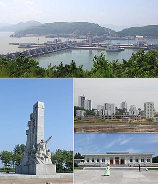
Nampo, also spelled Namp'o, is a city in North Korea which is the country's fourth-largest by population. The city is an important seaport in the country as it lies on the northern shore of the Taedong River, 15 km east of the river's mouth. Formerly known as Chinnamp'o, it was a provincial-level "Directly Governed City" ("Chikhalsi") from 1980 to 2004, and was designated a "Special City" in 2010. Nampo is approximately 50 km southwest of Pyongyang, at the mouth of the Taedong River. Since North Korean independence, the city has developed a wide range of industry and has seen significant recent redevelopment.
The Asian Highway Network (AH), also known as the Great Asian Highway, is a cooperative project among countries in Asia and the United Nations Economic and Social Commission for Asia and the Pacific (ESCAP) to improve their connectivity via highway systems. It is one of the three pillars of the Asian Land Transport Infrastructure Development (ALTID) project, endorsed by the ESCAP commission at its 48th session in 1992, comprising Asian Highway, Trans-Asian Railway (TAR) and facilitation of land transport projects.
A limited-access road, known by various terms worldwide, including limited-access highway, dual-carriageway, expressway, and partial controlled-access highway, is a highway or arterial road for high-speed traffic which has many or most characteristics of a controlled-access highway, including limited or no access to adjacent property, some degree of separation of opposing traffic flow, use of grade separated interchanges to some extent, prohibition of slow modes of transport, such as bicycles, horse-drawn vehicles or ridden horses, or self-propelled agricultural machines; and very few or no intersecting cross-streets or level crossings. The degree of isolation from local traffic allowed varies between countries and regions. The precise definition of these terms varies by jurisdiction.
The Tōmei Expressway is a national expressway on the island of Honshū in Japan. It is operated by Central Nippon Expressway Company. The expressway is designated as E1 under the "2016 Proposal for Realization of Expressway Numbering", because it parallels National Route 1. It is a part of the Asian Highway Network. AH1
A controlled-access highway is a type of highway that has been designed for high-speed vehicular traffic, with all traffic flow—ingress and egress—regulated. Common English terms are freeway, motorway, and expressway. Other similar terms include throughway or thruway and parkway. Some of these may be limited-access highways, although this term can also refer to a class of highways with somewhat less isolation from other traffic.
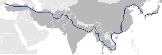
Asian Highway 1 (AH1) is the longest route of the Asian Highway Network, running 20,557 km (12,774 mi) from Tokyo, Japan via Korea, China, Southeast Asia, Bangladesh, India, Pakistan, and Iran to the border between Turkey and Bulgaria west of Istanbul where it joins end-on with European route E80, running all the way to Lisbon, Portugal.
Asian Highway 6 (AH6) is a route in the Asian Highway Network in Asia and Europe. It runs from Busan, South Korea to the border between Russia and Belarus. Altogether it is 10,533 kilometres (6,545 mi) long.
Rail transport in South Korea is a part of the transport network in South Korea and an important mode of the conveyance of people and goods, though railways play a secondary role compared to the road network. The network consists of 4,285 km (2,663 mi) of standard-gauge lines connecting all major cities with the exception of Jeju City on Jeju Island, which does not have railways; of the network, 2,790 km (1,730 mi) are double-tracked and 3,187 km (1,980 mi) are electrified. In 2018, rails carried 11.5 percent of all traffic in South Korea – 134.8million passengers and 30.9milliontonnes of freight – with roads carrying 88.3 percent.
This article describes the highway systems available in selected countries.
The Pyongyang-Kaesong Motorway, is a controlled-access highway in North Korea. It connects the capital Pyongyang to the Joint Security Area at the Korean Demilitarized Zone via Sariwon and Kaesong. The distance to Seoul in South Korea is present on signs on the highway, although it is not possible to cross the border to South Korea.
The Highways in Albania are the central state and main transport network in Albania. The motorways and expressways are both part of the national road network. The motorways are primary roads with a speed limit of 110 kilometres per hour (68 mph). They have white on green road signs such as in Italy and other countries nearby. The expressways are the secondary roads, also dual carriageways, but without an emergency lane. They have a speed limit of 90 kilometres per hour (56 mph). They have white on blue road signs.
Cycling has become a common mode of transport in North Korea since its economic transition in the early 1990s.
The Pyongyang–Sinŭiju Motorway (Korean: 평양신의주고속도로) is a motorway in North Korea under construction, which will be built parallel to the Pyongyang–Sinŭiju line and will connect Pyongyang with Sinŭiju. The Chinese border city Dandong is to be reached via Sino-Korean Friendship Bridge. The Pyongyang–Sinŭiju Expressway is said to be 387.1 kilometers long.
Malir Expressway is a 39 km under construction expressway starting from KPT Interchange, passes through Qayyumabad and conclude at the Karachi-Hyderabad Motorway near Kathore, along the Malir River in Karachi, Pakistan. One of the major infrastructure developments in Karachi city which is unviable for the provincial government and detrimental to the city's climate. It was announced that half of it will be opened on 14 August 2023 which has been indefinitely delayed since the Asian Development Bank has withdrawn the funding for the construction ADB decides against financing Karachi’s Malir Expressway; as of right now there is illegal excavation happening on the Malir River bed and the fields of Malir; it is unlikely that Expressway will be completed given the litigation and damage to the only surviving river in Karachi.
This page is based on this Wikipedia article Text is available under the CC BY-SA 4.0 license; additional terms may apply. Images, videos and audio are available under their respective licenses.