
The Republic of Suriname has a number of forms of transport. Transportation emissions are an increasing part of Suriname's contributions to climate change, as part of the Nationally Determined Contributions for the Paris Agreement, Suriname has committed to emissions controls for vehicles and increased public transit investment.

Brokopondo is a district of Suriname. Its capital city is Brokopondo; other towns include Brownsweg and Kwakoegron.

Nickerie is a district of Suriname, on the north-west coast. Nickerie's capital city is Nieuw-Nickerie. Another town is Wageningen. The district borders the Atlantic Ocean to the north, the Surinamese district of Coronie to the east, the Surinamese district of Sipaliwini to the south and the region of East Berbice-Corentyne in Guyana to the west.

Para is a district of northern Suriname. Para's capital city is Onverwacht, with other towns including Paranam, and Zanderij. Para has a population of 24,700 and an area of 5,393 km2. The district is the mining and forestry centre of Suriname, with many large bauxite mining operations operating. The district is a mixture of forest and savannas.

Sipaliwini is the largest district of Suriname, located in the south. Sipaliwini is the only district that does not have a regional capital, as it is directly administered by the national government in Paramaribo.

Nieuw Nickerie is the third largest city in Suriname with a population estimated at 12,818. It is the capital city of the Nickerie district, and the terminus of the East-West Link.

Brokopondo is the capital town of the Brokopondo District, Suriname. It is located on the west shore of the Suriname river, just north of the Afobaka dam. Brokopondo can be reached via the Afobakaweg from Paranam to Afobaka.
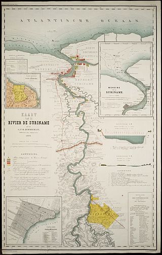
The Suriname River is 480 km long and flows through the country Suriname. Its sources are located in the Guiana Highlands on the border between the Wilhelmina Mountains and the Eilerts de Haan Mountains. The river flows below the reservoir along Brokopondo, Berg en Dal, the migrant communities Klaaskreek and Nieuw-Lombé, Jodensavanne, Carolina, Ornamibo and Domburg, before reaching the capital Paramaribo on the left bank and Meerzorg on the right bank. At Nieuw-Amsterdam it is joined by the Commewijne and immediately thereafter at the sandspit Braamspunt it flows into the Atlantic Ocean.

Brownsweg is a town and resort in Suriname in the Brokopondo District. Its population at the 2012 census was 4,793.

Pokigron is a town in Suriname located on Brokopondo Reservoir. It is located in the Boven Suriname municipality (resort) in the Sipaliwini District. It has a population of approximately 400 people in 2018. Pokigron is located at the end of a paved road via Brownsweg to the Afobakaweg. Pokigron is often referred to as Atjoni which is the nearby quay, and literally the end of the road. Villages to the South of Pokigron have to be accessed by boat. The village is home to Maroons of the Saramaka tribe.
The Initiative for the Integration of the Regional Infrastructure of South America (IIRSA) is a development plan to link South America's economies through new transportation, energy, and telecommunications projects.
Baikoetoe is a village in Sarakreek resort in Brokopondo District in Suriname. It is located on Brokopondo Reservoir.
The (northern) East-West Link is a road in Suriname between Albina in the eastern part of the country to Nieuw Nickerie in the western part, via the capital city of Paramaribo. The southern East-West Link connects Paramaribo with Apoera via Bitagron. Construction of the road link started in the 1960s.

South Drain, also Zuiddrain, is a town in western Suriname. Since the pavement of 32 kilometres (20 mi) road section to Nieuw Nickerie, it is the final destination of the northern East-West Link. The European Union funded the reconstruction, which started in 2007, with 13.2 million euro. The section was opened on 30 April 2010. There is a jeep trail between South Drain and Apoera, connecting the Northern East-West Link with the Southern East-West Link. Contrary to earlier plans, the pavement of this road is not imminent.
Poesoegroenoe or Pusugrunu or Psugrunu is a Matawai village in Boven Saramacca, Sipaliwini District, central Suriname. The village lies along the Saramacca River and is the residence of the gaanman of the Matawai maroons.
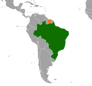
Brazil – Suriname relations refer to the bilateral relations between the Federative Republic of Brazil and the Republic of Suriname. Diplomatic relations were established on 3 March 1976. Brazil has an embassy in Paramaribo since the independence of Suriname on 25 November 1975. Suriname has an embassy in Brasília since 1976, and a consulate in Belém since 2012.

The Desiré Delano Bouterse Highway is the first motorway in Suriname between Afobakaweg connecting Paramaribo and Brokopondo to the John F. Kennedyweg near Johan Adolf Pengel International Airport. The motorway opened on 15 May 2020 12:00.

Paramacca is a resort in Suriname, located in the Sipaliwini District. The population is estimated between 1,500 and 2,000 people. In 1983, the Sipaliwini District was created, and the eastern part became the resort of Tapanahony. The Paramacca resort is the northern part of Tapanahony, and mainly inhabited by the Paramaccan people, the border of the resorts is the island of Bofoo Tabiki in the Marowijne River.
Nieuw-Koffiekamp is a village in the resort of Brownsweg in the Brokopondo District of Suriname. It is a transmigration village built for the inhabitants of Koffiekamp which was flooded by the Brokopondo Reservoir after the construction of the Afobaka Dam.


