Roaring Springs, Texas

Last updated

Roaring Springs, Texas
RoaringSprings3 (1 of 1).jpg
Downtown Roaring Springs, Texas
TXMap-doton-RoaringSprings.PNG
Location of Roaring Springs, Texas
Motley County RoaringSprings.svg
Coordinates: 33°54′3″N100°51′28″W / 33.90083°N 100.85778°W / 33.90083; -100.85778
Country United States
State Texas
County Motley
Area
[1]
  Total1.06 sq mi (2.75 km2)
  Land1.06 sq mi (2.75 km2)
  Water0.00 sq mi (0.00 km2)
Elevation
2,507 ft (764 m)
Population
 (2010)
  Total234
  Estimate 
(2019) [2]
231
  Density217.51/sq mi (84.00/km2)
Time zone UTC-6 (Central (CST))
  Summer (DST) UTC-5 (CDT)
ZIP code
79256
Area code 806
FIPS code 48-62528 [3]
GNIS feature ID1366557 [4]
Windmill Cafe in Roaring Springs Windmill Cafe, Roaring Springs, TX IMG 1572.JPG
Windmill Cafe in Roaring Springs
Travelers Inn Bed and Breakfast Travelers Inn in Roaring Springs, TX IMG 1570.JPG
Travelers Inn Bed and Breakfast
The Thacker Jewelry Company in Roaring Springs is a manufacturing and retail outlet still in production. There is also a larger Thacker's store in Lubbock. Thacker Jewelry, Roaring Springs, TX IMG 1569.JPG
The Thacker Jewelry Company in Roaring Springs is a manufacturing and retail outlet still in production. There is also a larger Thacker's store in Lubbock.
First Baptist Church of Roaring Springs First Baptist Church, Roaring Springs, TX IMG 1575.JPG
First Baptist Church of Roaring Springs

Roaring Springs is a town in Motley County, Texas, United States. The population was 265 at the 2000 census.

Contents

Roaring Springs was originally an Indian campground. At the time of the recapture of Cynthia Ann Parker in Foard County, Roaring Springs was the main Comanche outpost. It was known for the purity of its water. In 1912, the community was laid out in the anticipation of service from the Quanah, Acme and Pacific Railway, operated by Samuel Lazarus (1855–1926). The name "Roaring Springs" was adopted in 1913, when the railroad initiated service. A brick depot was soon established at the end of Broadway Street and handled passenger and freight traffic until 1971. The next year the depot was purchased by the town. [6]

Geography

Roaring Springs is located at 33°54′3″N100°51′28″W / 33.90083°N 100.85778°W / 33.90083; -100.85778 (33.900716, –100.857640). [7]

According to the United States Census Bureau, the town has a total area of 1.1 square miles (2.8 km2), all of it land.

Demographics

Historical population
CensusPop.Note
1930 405
1940 51426.9%
1950 435−15.4%
1960 398−8.5%
1970 308−22.6%
1980 3152.3%
1990 264−16.2%
2000 2650.4%
2010 234−11.7%
2019 (est.)231 [2] −1.3%
U.S. Decennial Census [8]

2020 census

Roaring Springs racial composition [9]
(NH = Non-Hispanic) [lower-alpha 1]
RaceNumberPercentage
White (NH)19087.56%
Some Other Race (NH)10.46%
Mixed/Multi-Racial (NH)115.07%
Hispanic or Latino 156.91%
Total217

As of the 2020 United States census, there were 217 people, 108 households, and 58 families residing in the town.

2000 census

As of the census [3] of 2000, there were 265 people, 117 households, and 82 families residing in the town. The population density was 248.4 inhabitants per square mile (95.9/km2). There were 145 housing units at an average density of 135.9 per square mile (52.5/km2). The racial makeup of the town was 91.70% White, 1.51% African American, 6.04% from other races, and 0.75% from two or more races. Hispanic or Latino of any race were 8.30% of the population.

There were 117 households, out of which 24.8% had children under the age of 18 living with them, 54.7% were married couples living together, 11.1% had a female householder with no husband present, and 29.9% were non-families. 25.6% of all households were made up of individuals, and 15.4% had someone living alone who was 65 years of age or older. The average household size was 2.26 and the average family size was 2.68.

In the town, the population was spread out, with 23.0% under the age of 18, 4.5% from 18 to 24, 22.3% from 25 to 44, 23.8% from 45 to 64, and 26.4% who were 65 years of age or older. The median age was 45 years. For every 100 females, there were 103.8 males. For every 100 females age 18 and over, there were 98.1 males.

The median income for a household in the town was $26,250, and the median income for a family was $30,625. Males had a median income of $25,625 versus $16,750 for females. The per capita income for the town was $14,901. About 9.3% of families and 18.1% of the population were below the poverty line, including 34.7% of those under the age of eighteen and 10.8% of those 65 or over.

Education

The Town of Roaring Springs is served by the Motley County Independent School District.

Related Research Articles

<span class="mw-page-title-main">Motley County, Texas</span> County in Texas, United States

Motley County is a county located in the U.S. state of Texas. As of the 2020 census, its population was 1,063, making it the 10th-least populous county in Texas. Its county seat is Matador. The county was created in 1876 and organized in 1891. It is named for Junius William Mottley, a signer of the Texas Declaration of Independence. Mottley's name is spelled incorrectly because the bill establishing the county misspelled his name. Motley County was one of 30 prohibition, or entirely dry, counties in Texas, but is now a wet county.

<span class="mw-page-title-main">Zolfo Springs, Florida</span> Town in the state of Florida, United States

Zolfo Springs is a town in Hardee County, Florida, United States. It is part of the Florida Heartland region. The population was 1,737 at the 2020 census.

<span class="mw-page-title-main">Stockton, Iowa</span> City in Iowa, United States

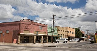
Stockton is a city in Muscatine County, Iowa, United States. The population was 176 at the time of the 2020 census. It is part of the Muscatine Micropolitan Statistical Area.

<span class="mw-page-title-main">Cope, South Carolina</span> Town in South Carolina, United States

Cope is a town in Orangeburg County, South Carolina, United States. The population was 65 at the 2020 census, a decline from 80 in 2010.

<span class="mw-page-title-main">Redwater, Texas</span> City in Texas, United States

Redwater is a city in Bowie County, Texas, United States. The population was 853 at the 2020 census. It is part of the Texarkana metropolitan area.

<span class="mw-page-title-main">Bangs, Texas</span> City in Texas, United States

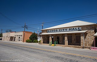
Bangs is a city located in Brown County in west-central Texas, United States. The population was 1,603 at the 2010 census.

<span class="mw-page-title-main">Baird, Texas</span> City in Texas, United States

Baird is a city and the county seat of Callahan County, Texas, United States. Its population was 1,479 at the 2020 census. The city is named after Matthew Baird, the owner and director of the Texas and Pacific Railway. The railway depot is now operated as the visitor center and a transportation museum.

<span class="mw-page-title-main">Dickens, Texas</span> City in Texas, United States

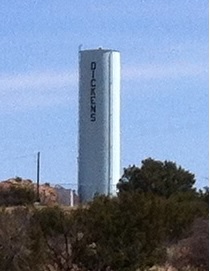
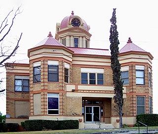
Dickens is a city in and the county seat of Dickens County, Texas, United States. The population was 286 at the 2010 census, down from 332 at the 2000 census.

<span class="mw-page-title-main">Rocksprings, Texas</span> Town in Texas, United States

Rocksprings is a town in and the county seat of Edwards County, Texas, United States. As of the 2010 census, the town population was 1,182, down from 1,285 at the 2000 census. The town received its name from natural springs associated with the porous limestone rocks in the area.

<span class="mw-page-title-main">Haskell, Texas</span> City in Texas, United States

Haskell is a city in central Haskell County, Texas, United States. As of the 2010 census, the city population was 3,322. It is the Haskell county seat.

<span class="mw-page-title-main">Neylandville, Texas</span> Town in Texas, United States

Neylandville is a town in Hunt County, Texas, United States. The population was 97 at the 2010 census, up from 56 at the 2000 census.

<span class="mw-page-title-main">Brackettville, Texas</span> City in Texas, United States

Brackettville is a city in Kinney County, Texas, United States. The population was 1,341 at the 2020 census, down from 1,688 at the 2010 census. It is the county seat of Kinney County.

<span class="mw-page-title-main">Buffalo Springs, Texas</span> Village in Texas, United States

Buffalo Springs is a village in Lubbock County, Texas, United States. The population was 453 at the 2010 census. It is part of the Lubbock Metropolitan Statistical Area.

<span class="mw-page-title-main">Idalou, Texas</span> City in Texas, United States

Idalou is a city in Lubbock County, Texas, United States. It is located 7 miles (11 km) northeast of Lubbock near the intersection of Farm to Market Road 400 and US 62/US 82/SH 114. The population was 2,250 at the 2010 census. It is part of the Lubbock Metropolitan Statistical Area.

<span class="mw-page-title-main">Shallowater, Texas</span> Community in Texas, United States

Shallowater is a city in Lubbock County, Texas, United States. Shallowater is on U.S. Route 84 and the Burlington Northern Santa Fe line, 12 miles (19 km) northwest of Lubbock. Its population was 2,484 at the 2010 census. It is part of the Lubbock metropolitan statistical area.

<span class="mw-page-title-main">Wolfforth, Texas</span> City in Texas, United States

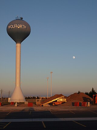
Wolfforth is a town located in Lubbock County, Texas, United States. It is a southwestern suburb of Lubbock. The population was 5,521 at the 2020 census.

<span class="mw-page-title-main">Loraine, Texas</span> Town in Mitchell County, Texas, United States

Loraine is a town in Mitchell County, Texas, United States. The population was 504 at the 2020 United States Census

<span class="mw-page-title-main">Detroit, Texas</span> Town in Texas, United States

Detroit (dɪˈtɹɔɪt) is a town in Red River County, Texas, United States. The population was 704 at the 2020 census.

<span class="mw-page-title-main">Trent, Texas</span> Town in Texas, United States

Trent is a town in Taylor County, Texas, United States, that was established in 1881. The population was 337 at the 2010 census. It is part of the Abilene, Texas Metropolitan Statistical Area. Trent, Texas was named in honor of West Texas pioneer and cattleman, Isaac Riley Trent.

<span class="mw-page-title-main">Poth, Texas</span> Town in Texas, United States

Poth is a town in Wilson County, Texas, United States. The population was 1,819 at the 2020 census. It is part of the San Antonio metropolitan area.

References

  1. "2019 U.S. Gazetteer Files". United States Census Bureau. Retrieved August 7, 2020.
  2. 1 2 "Population and Housing Unit Estimates". United States Census Bureau. May 24, 2020. Retrieved May 27, 2020.
  3. 1 2 "U.S. Census website". United States Census Bureau . Retrieved January 31, 2008.
  4. "US Board on Geographic Names". United States Geological Survey. October 25, 2007. Retrieved January 31, 2008.
  5. "Welcome to Thacker Jewelry". thackerjewelry.net. Retrieved April 10, 2011.
  6. "Roaring Springs Depot", Historical marker, Texas Historical Commission, Roaring Springs, Texas
  7. "US Gazetteer files: 2010, 2000, and 1990". United States Census Bureau. February 12, 2011. Retrieved April 23, 2011.
  8. "Census of Population and Housing". Census.gov. Retrieved June 4, 2015.
  9. "Explore Census Data". data.census.gov. Retrieved May 19, 2022.
  10. https://www.census.gov/ [ not specific enough to verify ]
  11. "About the Hispanic Population and its Origin". www.census.gov. Retrieved May 18, 2022.
  1. Note: the US Census treats Hispanic/Latino as an ethnic category. This table excludes Latinos from the racial categories and assigns them to a separate category. Hispanics/Latinos can be of any race. [10] [11]