
San Antonio (; from Spanish, "Saint Anthony," officially the City of San Antonio, is the seventh-most populous city in the United States, and the second-most populous city in both Texas and the Southern United States, with more than 1.5 million residents. Founded as a Spanish mission and colonial outpost in 1718, the city became the first chartered civil settlement in present-day Texas in 1731. The area was still part of the Spanish Empire, and later of the Mexican Republic. It is the state's oldest municipality, having celebrated its 300th anniversary on May 1, 2018.

Bexar County is a county of the U.S. state of Texas. As of the 2010 census, the population was 1,714,773, and a 2018 estimate put the population at 1,986,049. It is the 16th-most populous county in the nation and the fourth-most populated in Texas. Its county seat is San Antonio, the second-most populous city in Texas and the seventh-largest city in the United States.

The Battle of San Jacinto, fought on April 21, 1836, in present-day Harris County, Texas, was the decisive battle of the Texas Revolution. Led by General Sam Houston, the Texian Army engaged and defeated General Antonio López de Santa Anna's Mexican army in a fight that lasted just 18 minutes. A detailed, first-hand account of the battle was written by General Houston from Headquarters of the Texian Army, San Jacinto, on April 25, 1836. Numerous secondary analyses and interpretations have followed, several of which are cited and discussed throughout this entry.

The Battle of the Alamo was a pivotal event in the Texas Revolution. Following a 13-day siege, Mexican troops under President General Antonio López de Santa Anna reclaimed the Alamo Mission near San Antonio de Béxar, killing the Texian and immigrant occupiers. Santa Anna's cruelty during the battle inspired many Texians, both legal Texas settlers and illegal immigrants from the United States, to join the Texian Army. Buoyed by a desire for revenge, the Texians defeated the Mexican Army at the Battle of San Jacinto, on April 21, 1836, ending the rebellion.

Erastus "Deaf" Smith was an American frontiersman noted for his part in the Texas Revolution and the Army of the Republic of Texas. He fought in the Grass Fight and the Battle of San Jacinto. After the war, Deaf Smith led a company of Texas Rangers.
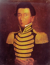
Juan Nepomuceno Seguín was a Spanish-Tejano political and military figure of the Texas Revolution who helped to establish the independence of Texas. Numerous places and institutions are named in his honor, including the county seat of Seguin in Guadalupe County, the Juan N. Seguin Memorial Interchange in Houston, Juan Seguin Monument in Seguin, World War II Liberty Ship SS Juan N. Seguin, Seguin High School in Arlington.
The Grass Fight was a small battle during the Texas Revolution, fought between the Mexican Army and the Texian Army. The battle took place on November 26, 1835, just south of San Antonio de Béxar in the Mexican region of Texas. The Texas Revolution had officially begun on October 2 and by the end of the month the Texian had initiated a siege of Béxar, home of the largest Mexican garrison in the province. Bored with the inactivity, many of the Texian soldiers returned home; a smaller number of adventurers from the United States arrived to replace them. After the Texian Army rejected commander-in-chief Stephen F. Austin's call to launch an assault on Béxar on November 22, Austin resigned from the army. The men elected Edward Burleson their new commander-in-chief.
The Siege of Béxar was an early campaign of the Texas Revolution in which a volunteer Texian army defeated Mexican forces at San Antonio de Béxar. Texians had become disillusioned with the Mexican government as President and General Antonio Lopez de Santa Anna's tenure became increasingly dictatorial. In early October, 1835, Texas settlers gathered in Gonzales to stop Mexican troops from reclaiming a small cannon. The resulting skirmish, known as the Battle of Gonzales, launched the Texas Revolution. Men continued to assemble in Gonzales and soon established the Texian Army. Despite a lack of military training, well-respected local leader General Stephen F. Austin was elected commander.

The geography of Texas is diverse and large. Occupying about 7% of the total water and land area of the U.S., it is the second largest state after Alaska, and is the southernmost part of the Great Plains, which end in the south against the folded Sierra Madre Oriental of Mexico. Texas is in the South Central United States of America, and is considered to form part of the U.S. South and also part of the U.S. Southwest.

State Highway 211 or SH 211 is a 11.184-mile (17.999 km) state highway west of the city of San Antonio in the U.S. state of Texas. This route was designated in 1986 as an access route to the Texas Research Park. Portions of the route were built, but significant landowner opposition kept the connecting section from being completed. The completed sections of the route consist of a southern section from U.S. Highway 90 north to Farm to Market Road 1957 and a northern section from FM 471 north to SH 16. The Texas Transportation Commission has approved a pass-through toll agreement that Bexar County submitted in October 2008. This proposal will allow for development of a segment of SH 211 from 1.33 miles south of FM 1957 to FM 471 and improvements to FM 1957 from Loop 1604 to the Medina County line. The completion of the section between FM 1957 to FM 471 will finally allow for seamless travel from Hwy 90 at the south end, north to SH 16. The improvements to FM 1957 will allow for the necessary widening of the two-lane roadway which is dealing with new suburban growth and traffic for which it wasn't built to handle.

San Antonio–New Braunfels is an eight-county metropolitan area in the U.S. state of Texas defined by the Office of Management and Budget (OMB). The metropolitan area straddles South Texas and Central Texas and is on the southwestern corner of the Texas Triangle. The official 2018 U.S. Census estimate showed the metropolitan area's population at 2,550,960—up from a reported 1,711,103 in 2000—making it the 24th largest metropolitan area in the United States. Austin–Round Rock lies about 80 miles northeast of Greater San Antonio.
Dionicio Rodriguez (1891–1955) was a Mexican-born artist and architect whose work can be seen in Alabama, Arkansas, Illinois, Maryland, Michigan, New Mexico, Tennessee, and Texas, as well as Washington, D.C. and Mexico City.

The Texian Army, also known as the Revolutionary Army and Army of the People, was the land warfare branch of the Texian armed forces during the Texas Revolution. It spontaneously formed from the Texian Militia in October 1835 following the Battle of Gonzales. Along with the Texian Navy, it helped the Republic of Texas win independence from the Centralist Republic of Mexico on May 14, 1836 at the Treaties of Velasco. Although the Texas Army was officially established by the Consultation of the Republic of Texas on November 13, 1835, it did not replace the Texian Army until after the Battle of San Jacinto.
The City of San Antonio is one of the oldest Spanish colonization of the European settlements in Texas and was, for decades, its largest city. Before Spanish colonization, the site was occupied for thousands of years by varying cultures of indigenous peoples. The historic Payaya Indians were likely those who encountered the first Europeans.
Salvador Flores served as a volunteer in the Texan Army in 1835–1836. He was instrumental in organizing and commanding Texian volunteers in support of the Texas Revolution. He participated in many battles and would rise through the ranks to reach Captain status during the fight for Texas independence from Mexico. Salvador continued to provide protection for the ranches and settlers of Texas throughout the Republic years.

Manuel Flores served as a volunteer in the Texas army in 1835–1838. Fighting and commanding, he rose through the ranks to reach sergeant status during the fight for Texas independence and was commissioned a captain during the Republic years.

Presidio de Béxar was a Spanish fort built near the San Antonio River, located in what is now San Antonio, Texas, in the United States. It was designed for protection of the mission San Antonio de Valero and the Villa de Bejar. The Presidio de Bejar was founded on May 5, 1718 by Spanish Governor Martin de Alarcon and his 35 Presidio Soldiers. The Villa de Bejar is known for being the first Spanish settlement of San Antonio and consisted of the families of the Presidio Soldiers and those of the prior expeditions. It also served to secure Spain's claim to the region from French, English and American aggression.

Jose Miguel de Arciniega (1793–1849) was a Mexican military explorer and legislator. He was mayor of San Antonio, Texas, in 1830 and 1833.

The 2019–20 coronavirus pandemic reached the U.S. state of Texas in January 2020.
 Rock formation
 Rock formation
 Rock formation
 Rock formation


