
Monroe County is a county in the state of Florida. As of the 2020 census, the population was 82,874. Its county seat is Key West. Monroe County includes the islands of the Florida Keys and comprises the Key West Micropolitan Statistical Area. Over 99.9% of the county's population lives on the Florida Keys. The mainland, which is part of the Everglades, comprises 87% of the county's land area and is virtually uninhabited with only 17 people in total.

Pinellas County is a county located on the west central coast of the U.S. state of Florida. As of the 2020 census, the population was 959,107. The county is part of the Tampa–St. Petersburg–Clearwater, Florida Metropolitan Statistical Area. Clearwater is the county seat. St. Petersburg is the largest city as well as the largest city in Florida that is not a county seat.
Florida City is a city in Miami-Dade County, Florida, United States. It is the southernmost municipality in the South Florida metropolitan area. Florida City is primarily a Miami suburb and a major agricultural area. As of the 2020 census, it had a population of 13,085, up from 11,245 in 2010.

Islandia is an unincorporated community and former city in Miami-Dade County, Florida, United States. It is located in the upper Florida Keys on the islands of Elliott Key and other nearby keys, such as Totten Key. It was the only municipality in the Florida Keys not located in neighboring Monroe County. The population was 18 at the 2010 Census. Most residents of the city were National Park Service employees.

Islamorada is an incorporated village in Monroe County, Florida, United States. It is located directly between Miami and Key West on five islands—Tea Table Key, Lower Matecumbe Key, Upper Matecumbe Key, Windley Key and Plantation Key—in the Florida Keys. As of the 2020 census, the village had a population of 7,107, up from 6,119 in 2010.
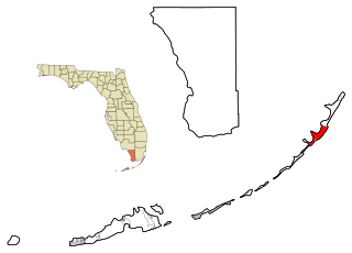
Key Largo is an unincorporated area and census-designated place in Monroe County, Florida, United States, located on the island of Key Largo in the upper Florida Keys. The population was 12,447 at the 2020 census, up from 10,433 in 2010. The name comes from the Spanish Cayo Largo, or "long key". It is both the first island and town of the Florida Keys to be reached from the Overseas Highway to Key West. It was also the location of one of the stations of the Overseas Railroad.

Marathon is a city in the middle of the Florida Keys, in Monroe County, Florida, United States. As of the 2020 census, the city had a population of 9,689, up from 8,297 in 2010.
North Key Largo is an unincorporated area and census-designated place (CDP) in Monroe County, Florida, United States. The population was 1,431 at the 2020 census, up from 1,244 in 2010. It includes two private clubs, the Ocean Reef Club and the Key Largo Anglers Club, and is reached from the mainland via the Card Sound Bridge.
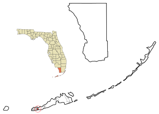
Stock Island is a census-designated place (CDP) and unincorporated community on an island of the same name in Monroe County, Florida, United States. The population of the CDP was 4,722 at the 2020 census, up from 3,919 in 2010. It is located on the portion of the island south of US 1. It is supposedly named for the herds of livestock formerly kept there. Alternatively, some local historians suggest that it may be named for an early settler.

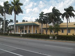
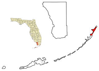
Tavernier is a census-designated place (CDP) and unincorporated community in Monroe County, Florida, United States on Key Largo, the largest island in the upper Florida Keys. Tavernier's population was 2,530 at the 2020 census, up from 2,136 in 2010.

Lake Harbor is a census-designated place (CDP) in Palm Beach County, Florida, United States. The population was 49 at the 2020 census. It located along the southern banks of Lake Okeechobee, at the beginning of the Miami Canal. John Stretch Park is also located alongside the north end of Lake Harbor and the lake.

Largo is the third largest city in Pinellas County, Florida, United States, as well as the fourth largest in the Tampa Bay area. As of the 2020 Census, the city had a population of 82,500, up from 69,371 in 2000.

Key Largo is an island in the upper Florida Keys archipelago and is the largest section of the keys, at 33 miles (53 km) long. It is one of the northernmost of the Florida Keys in Monroe County, and the northernmost of the keys connected by U.S. Highway 1. Three census-designated places are on the island of Key Largo: North Key Largo, near the Card Sound Bridge, Key Largo, eight to nine miles from the southern end of the island, and Tavernier, at the southern end of the island. As of 2010, the three places have a combined population of 13,850. None of Key Largo is an incorporated municipality, so it is governed at the local level by Monroe County.

Plantation Key is an island in Monroe County, Florida, United States. It is located in the upper Florida Keys on U.S. 1, between Key Largo and Windley Key.
No Name Harbor is a natural harbor on Key Biscayne, Florida. It is located within the boundaries of Bill Baggs Cape Florida State Park. In the 19th century, the site served as a food-rich rookery for herons, egrets, and other species of wildlife. Originally, the site was privately owned prior to the creation of the state park. Several development plans indicated the land was slated for the construction of condominiums and residential homes. The surrounding land was cleared for development in the 1950s, and charts identified the body of water as "No Name Harbor". The plans failed, and the harbor's name was retained.

SS Benwood was a steam cargo ship of the early twentieth century. Built by Craig, Taylor & Co Ltd., Stockton on Tees, she entered service with Joseph Hoult & Co. Ltd, Liverpool. She passed through several owners, before being lost in a collision off the coast of Key Largo, Florida in 1942. Her wreck is now a popular dive site.
Garden Cove is an unincorporated community in Monroe County, Florida, United States, located in the upper Florida Keys on Key Largo immediately southwest and bordering the Census-designated place (CDP) of North Key Largo.
Jewfish is an unincorporated community in Monroe County, Florida, United States. It is located in the upper Florida Keys on Key Largo off U.S. Route 1. It is just west of the census-designated place (CDP) of North Key Largo.

The Jewfish Creek Bridge is a beam bridge in the Florida Keys. Spanning both Jewfish Creek and Lake Surprise, it carries the Overseas Highway between the Florida Keys and the Florida mainland. The bridge is 65 feet (20 m) tall and opened in 2008, replacing a small drawbridge.


