Copiah County is a county located in the U.S. state of Mississippi. As of the 2010 census, the population was 29,449. The county seat is Hazlehurst.

Claiborne County is a county located in the U.S. state of Mississippi. As of the 2020 census, the population was 9,135. Its county seat is Port Gibson. The county is named after William Claiborne, the second governor of the Mississippi Territory.
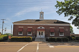
Port Gibson is a city in Claiborne County, Mississippi, United States. The population was 1,567 at the 2010 census. Port Gibson is the county seat of Claiborne County, which is bordered on the west by the Mississippi River. It is the site of the Claiborne County Courthouse.

The Natchez Trace, also known as the Old Natchez Trace, is a historic forest trail within the United States which extends roughly 440 miles (710 km) from Nashville, Tennessee, to Natchez, Mississippi, linking the Cumberland, Tennessee, and Mississippi rivers.

The Natchez Trace Parkway is a national parkway in the southeastern United States that commemorates the historic Natchez Trace and preserves sections of that original trail. Its central feature is a two-lane road that extends 444 miles (715 km) from Natchez, Mississippi, to Nashville, Tennessee. Access to the parkway is limited, with more than fifty access points in the states of Mississippi, Alabama, and Tennessee. The southern end of the route is in Natchez at its intersection with Liberty Road, and the northern end is northeast of Fairview, Tennessee, in the suburban community of Pasquo, at an intersection with Tennessee State Route 100. In addition to Natchez and Nashville, larger cities along the route include Jackson and Tupelo, Mississippi, and Florence, Alabama.
Hermanville is a census-designated place and unincorporated community in Claiborne County, in southwest Mississippi, United States. Its ZIP code is 39086.

Grand Gulf is a ghost town in Claiborne County, Mississippi, United States.

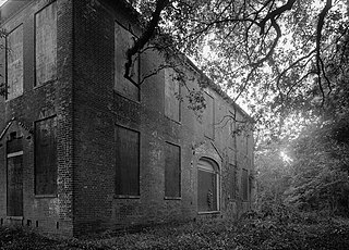
Church Hill is a small unincorporated community in Jefferson County, Mississippi, United States. It is located eight miles east of the Mississippi River and approximately 18 miles north of Natchez at the intersection of highway 553 and Church Hill Road. Church Hill was a community of wealthy cotton planters and enslaved people before the American Civil War. Soil erosion, which had been going on since well before the Civil War, caused the area to decline into a poor farming community with none of the land under cultivation by 1999. The area is remarkable because its antebellum buildings are mostly intact with few modern buildings having been built.

The Emerald Mound site, also known as the Selsertown site, is a Plaquemine culture Mississippian period archaeological site located on the Natchez Trace Parkway near Stanton, Mississippi, United States. The site dates from the period between 1200 and 1730 CE. It is the type site for the Emerald Phase of the Natchez Bluffs Plaquemine culture chronology and was still in use by the later historic Natchez people for their main ceremonial center. The platform mound is the second-largest Mississippian period earthwork in the country, after Monk's Mound at Cahokia, Illinois.
Middleton is a former town in Montgomery County, Mississippi, United States. Once a thriving commercial and educational center, Middleton was bypassed in 1859 when the Mississippi Central Railway built its line through nearby Winona. Businesses and residents followed the railroad, and Middleton was abandoned. Little remains of the town today but its cemetery, which was restored in 1992 by the Lions Club of Winona.
This is a list of the National Register of Historic Places listings in Claiborne County, Mississippi.
This is a list of the National Register of Historic Places listings in Madison County, Mississippi.
Seven segments of the historic Natchez Trace are listed on the National Register of Historic Places (NRHP). Also there are additional NRHP-listed structures and other sites along the Natchez Trace, which served the travelers of the trace and survive from the era of its active use.
The Van Dorn House is a historic hilltop residence in Port Gibson, Mississippi built circa 1830 for Peter Aaron Van Dorn and his wife. He was a lawyer from New Jersey who made his fortune in this area, having a practice, gaining political appointments, and becoming a cotton planter. This was the home for years for his large family in Port Gibson, including son Earl Van Dorn. The latter was a career U.S. Army officer who joined the Confederate Army after the start of the Civil War, ultimately reaching the rank of Major General.
Abijah Hunt (1762-1811) was an American merchant, planter and banker in the Natchez District.
Peter Aaron Van Dorn (1773–1837) was an American lawyer, judge and cotton planter in Mississippi. Born and raised in New Jersey, with a law degree from Princeton, as a young man he migrated to the Mississippi Territory, where he made his career and fortune. He became a major planter with a plantation on the Yazoo River, a law practice in Port Gibson, and a seat as a judge on the Orphan's Court. He was one of the founders of Jackson, Mississippi, designated as the capital when it became a state.

Mississippi Highway 462 is a state highway in western Mississippi. The route starts at U.S. Route 61 near Port Gibson, and it travels eastward. The road then turns northeastward, and the route ends at Willows Road and Old Port Gibson Road near Willows. MS 462 was designated around 1958, as a gravel road extending eastward from US 61 near Port Gibson. The road was extended to MS 461 from 1960 to 1963, then to the Natchez Trace Parkway from 1967 to 1998.

Old Greenville is a ghost town in Jefferson County, Mississippi, United States. The town was located along the old Natchez Trace and was once the largest town along the Trace. Nothing exists at the site today except the town's cemetery.

Mississippi Highway 547 (MS 547) is a state highway in southwestern Mississippi. The highway runs about 25 miles (40 km) long on a southeast to northwest direction, signed as a north–south route. It connects MS 28 at Allen with Pattison and U.S. Route 61 (US 61) in southern Port Gibson.