Rollingwood, California

Last updated

Rollingwood
Contra Costa County California Incorporated and Unincorporated areas Rollingwood Highlighted.svg
Location in Contra Costa County and the state of California
Usa edcp location map.svg
Red pog.svg
Rollingwood
Location in the United States
Coordinates: 37°57′55″N122°19′48″W / 37.96528°N 122.33000°W / 37.96528; -122.33000
Country Flag of the United States.svg  United States
State Flag of California.svg  California
County Contra Costa
Government
  TypeBoard of Supervisors
   County Board District 1:
John Gioia
   State Senate Nancy Skinner (D) [1]
   State Assembly Buffy Wicks (D) [2]
   U. S. Congress John Garamendi (D) [3]
Area
[4]
  Total0.166 sq mi (0.430 km2)
  Land0.166 sq mi (0.430 km2)
  Water0 sq mi (0 km2)  0%
Elevation
[5]
75 ft (23 m)
Population
 (2010)
  Total2,969
  Density18,000/sq mi (6,900/km2)
Time zone UTC-8 (PST)
  Summer (DST) UTC-7 (PDT)
Area code 510
FIPS code 06-62700
GNIS feature IDs 1853411, 2409202
[5]

Rollingwood is a census-designated place (CDP) in Contra Costa County, California, United States. As of the 2010 census, Rollingwood's population was 2,969.

Contents

Geography

According to the United States Census Bureau, the CDP has a total area of 0.2 square miles (0.52 km2), all of it land.

History

The federal government contracted David Bohannon, one of the nation's lead mass production developers, to develop Rollingwood. Federal officials approved bank loans to finance construction, requiring that the homes not be sold to African-Americans. [6]

In 1952, Wilbur Gary, an African-American navy war veteran, former shipyard worker, and building contractor, purchased a home in Rollingwood from fellow navy war veteran Lieutenant Commander Sidney Hogan. Gary's purchase provoked anger among residents of the formerly all-white town. Soon after the Garys arrived, a mob of 300 white residents gathered in front of Gary's house. The mob shouted racial epithets, hurled a brick through the family's window, and burned a cross on their front lawn. [7] [8]

Demographics

2010

The 2010 United States Census [9] reported that Rollingwood had a population of 2,969. The population density was 17,864.2 inhabitants per square mile (6,897.4/km2). The racial makeup of Rollingwood was 1,130 (38.1%) White, 220 (7.4%) African American, 28 (0.9%) Native American, 534 (18.0%) Asian, 22 (0.7%) Pacific Islander, 907 (30.5%) from other races, and 128 (4.3%) from two or more races. Hispanic or Latino of any race were 1,836 persons (61.8%).

The Census reported that 99.8% of the population lived in households and 0.2% were institutionalized.

There were 729 households, out of which 398 (54.6%) had children under the age of 18 living in them, 438 (60.1%) were opposite-sex married couples living together, 129 (17.7%) had a female householder with no husband present, 57 (7.8%) had a male householder with no wife present. There were 29 (4.0%) unmarried opposite-sex partnerships, and 7 (1.0%) same-sex married couples or partnerships. 70 households (9.6%) were made up of individuals, and 35 (4.8%) had someone living alone who was 65 years of age or older. The average household size was 4.06. There were 624 families (85.6% of all households); the average family size was 4.31.

The population was spread out, with 848 people (28.6%) under the age of 18, 366 people (12.3%) aged 18 to 24, 836 people (28.2%) aged 25 to 44, 669 people (22.5%) aged 45 to 64, and 250 people (8.4%) who were 65 years of age or older. The median age was 31.1 years. For every 100 females, there were 97.5 males. For every 100 females age 18 and over, there were 99.0 males.

There were 776 housing units at an average density of 4,669.1 per square mile (1,802.7/km2), of which 729 were occupied, of which 493 (67.6%) were owner-occupied, and 236 (32.4%) were occupied by renters. The homeowner vacancy rate was 1.8%; the rental vacancy rate was 6.3%. 1,945 people (65.5% of the population) lived in owner-occupied housing units and 1,018 people (34.3%) lived in rental housing units.

2000

As of the census [10] of 2000, there were 2,900 people, 734 households, and 629 families residing in the CDP. The population density was 14,036.3 inhabitants per square mile (5,419.4/km2). There were 757 housing units at an average density of 3,664.0 per square mile (1,414.7/km2). The racial makeup of the CDP was 33.14% White, 10.41% Black or African American, 1.10% Native American, 23.79% Asian, 0.45% Pacific Islander, 24.52% from other races, and 6.59% from two or more races. 42.24% of the population were Hispanic or Latino of any race.

There were 734 households, out of which 51.1% had children under the age of 18 living with them, 59.3% were married couples living together, 20.4% had a female householder with no husband present, and 14.2% were non-families. 11.7% of all households were made up of individuals, and 6.1% had someone living alone who was 65 years of age or older. The average household size was 3.94 and the average family size was 4.23.

In the CDP, the population was spread out, with 33.3% under the age of 18, 10.6% from 18 to 24, 29.8% from 25 to 44, 17.4% from 45 to 64, and 9.0% who were 65 years of age or older. The median age was 30 years. For every 100 females, there were 96.1 males. For every 100 females age 18 and over, there were 93.1 males.

The median income for a household in the CDP was $48,229, and the median income for a family was $51,875. Males had a median income of $31,048 versus $27,500 for females. The per capita income for the CDP was $13,428. About 12.0% of families and 12.8% of the population were below the poverty line, including 15.7% of those under age 18 and 6.0% of those age 65 or over.

Education

Rollingwood is in the West Contra Costa Unified School District. [11]

Related Research Articles

<span class="mw-page-title-main">Fairview, California</span> CDP in California, United States

Fairview is a census-designated place (CDP) in Alameda County, California, United States. It borders on the city of Hayward and the census-designated place of Castro Valley. The population was 11,341 at the 2020 census.

<span class="mw-page-title-main">Bayview-Montalvin, California</span> Former CDP in California, United States

Bayview-Montalvin is a former census-designated place (CDP) in Contra Costa County, California, United States. The population was 5,004 at the 2000 census.

<span class="mw-page-title-main">Diablo, California</span> Census-designated place in California, United States

Diablo is a census-designated place (CDP) in Contra Costa County, California, United States. The population was 1,158 at the 2010 census. It is located 2.5 miles (4.0 km) east-northeast of Danville.

<span class="mw-page-title-main">East Richmond Heights, California</span> Unincorporated community in California, United States

East Richmond Heights is an unincorporated community and census-designated place (CDP) in western Contra Costa County, California, United States. Its population was 3,280 at the 2010 census.

<span class="mw-page-title-main">Knightsen, California</span> Census-designated place in California, United States

Knightsen is a census-designated place (CDP) in Contra Costa County, California, in the United States. As of the 2010 census, the CDP population was 1,568, up from 861 reported in the 2000 census.

<span class="mw-page-title-main">Rodeo, California</span> Census-designated place in California, United States

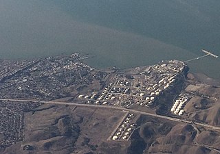
Rodeo is a census-designated place (CDP) located in Contra Costa County, California, in the East Bay sub-region of the San Francisco Bay Area, on the eastern shore of San Pablo Bay, 25 miles northeast of San Francisco. The population was 9,653 at the 2020 census. The town is named for the rodeos common in the late 19th century. Cattle from the surrounding hills were regularly driven down through the old town to a loading dock on the shoreline of San Pablo Bay for shipment to slaughterhouses, a practice which continued through the early 20th century. The town of Rodeo is served by the Interstate 80 freeway and State Route 4. The Southern Pacific Railroad main line passes through Rodeo. Rodeo has not been a stop on the railroad since the 1950s.

<span class="mw-page-title-main">Tara Hills, California</span> Census-designated place in California, United States

Tara Hills is a census-designated place (CDP) in Contra Costa County, California, United States. The population was 5,126 at the 2010 census.

<span class="mw-page-title-main">Vine Hill, California</span> Census-designated place in California, United States

Vine Hill is a census-designated place (CDP) in Contra Costa County, California, United States. The population was 3,761 at the 2010 census. It is located 2.25 miles (3.6 km) east of downtown Martinez.

<span class="mw-page-title-main">Waldon, California</span> Former Census-designated place in California, United States

Waldon is a former census-designated place (CDP) in Contra Costa County, California, United States. The population was 5,133 at the 2000 census. It is served by Pleasant Hill/​Contra Costa Centre station on the Bay Area Rapid Transit (BART) Yellow Line, and by Interstate 680. The area has been undergoing a series of transit-oriented development projects under the auspices of the Contra Costa Centre Transit Village public/private partnership.

<span class="mw-page-title-main">Raisin City, California</span> Census-designated place in California, United States

Raisin City is a census-designated place (CDP) in Fresno County, California, United States. The population was 380 at the 2010 census, up from 165 at the 2000 census. Raisin City is located 13 miles (21 km) south-southwest of downtown Fresno, at an elevation of 236 feet.

<span class="mw-page-title-main">Westhaven-Moonstone, California</span> Census-designated place in California, United States

Westhaven-Moonstone is a census-designated place (CDP) located in Humboldt County, California, United States. As of the 2010 census the population was 1,205, up from 1,044 at the 2000 census.

<span class="mw-page-title-main">Mesa, California</span> Census-designated place in California, United States

Mesa is a census-designated place (CDP) in Inyo County, California, United States. The population was 251 at the 2010 census, up from 214 at the 2000 census.

<span class="mw-page-title-main">Citrus, California</span> Census-designated place in California, United States

Citrus is a census-designated place (CDP) in Los Angeles County, California, United States. It is located in the San Gabriel Valley between Azusa to the north and west, Glendora to the east, and Covina to the south. The population was 10,866 at the 2010 census, up from 10,581 at the 2000 census. Citrus is named after Citrus Avenue, which passes through the community.

<span class="mw-page-title-main">Tamalpais-Homestead Valley, California</span> Census-designated place in California, United States

Tamalpais-Homestead Valley is a census-designated place (CDP) in Marin County, California, United States. The population was 11,492 at the 2020 census.

<span class="mw-page-title-main">Taylorsville, California</span> Census-designated place in California, United States

Taylorsville is a census-designated place (CDP) in Plumas County, California, United States. The population was 150 at the 2010 census, down from 154 at the 2000 census. The annual Stone Ranch Reunion is held in Taylorsville.

<span class="mw-page-title-main">Lakeview, California</span> Census-designated place in California, United States

Lakeview is a census-designated place (CDP) in Riverside County, California, United States. The population was 2,104 at the 2010 census, up from 1,619 at the 2000 census. The community is named for nearby Mystic Lake.

<span class="mw-page-title-main">Brownville, New Jersey</span> Populated place in Middlesex County, New Jersey, US

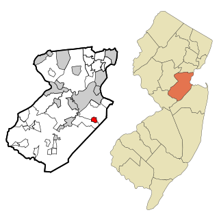
Brownville is an unincorporated community and census-designated place (CDP) located within Old Bridge Township, in Middlesex County, in the U.S. state of New Jersey. As of the 2010 United States Census, the CDP's population was 2,383.

<span class="mw-page-title-main">Chevy Chase (CDP), Maryland</span> Census-designated place in Maryland, United States

Chevy Chase is a census-designated place (CDP) in Montgomery County, Maryland, United States. The population was 10,176 at the 2020 census.

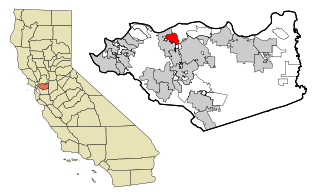
San Miguel is a census-designated place in Contra Costa County, California. San Miguel sits at an elevation of 249 feet (76 m). The 2010 United States census reported San Miguel's population was 3,392.

Lincoln is a census-designated place (CDP) consisting of the primary settlement in the town of Lincoln in Penobscot County, Maine, United States. The population was 2,884 at the 2010 census.

References

  1. "Senators". State of California. Retrieved April 1, 2013.
  2. "Members Assembly". State of California. Retrieved April 1, 2013.
  3. "California's 8th Congressional District - Representatives & District Map". Civic Impulse, LLC. Retrieved March 9, 2013.
  4. "2010 Census U.S. Gazetteer Files – Places – California". United States Census Bureau.
  5. 1 2 "Rollingwood". Geographic Names Information System . United States Geological Survey, United States Department of the Interior.
  6. Rothstein, Richard (May 2, 2017). The color of law : a forgotten history of how our government segregated America (First ed.). Liveright Publishing. p. 3. ISBN   978-1631492853 . Retrieved July 31, 2019.
  7. Rothstein, Richard (May 2, 2017). The Color of Law: A Forgotten History of How Our Government Segregated America. Liveright Publishing. ISBN   9781631492860 . Retrieved July 31, 2019.
  8. The Gary Family of Richmond Radio Free Richmond. Retrieved August 20, 2022.
  9. "2010 Census Interactive Population Search: CA - Rollingwood CDP". U.S. Census Bureau. Archived from the original on July 15, 2014. Retrieved July 12, 2014.
  10. "U.S. Census website". United States Census Bureau . Retrieved January 31, 2008.
  11. "2020 CENSUS - SCHOOL DISTRICT REFERENCE MAP: Contra Costa County, CA" (PDF). U.S. Census Bureau . Retrieved December 25, 2022.