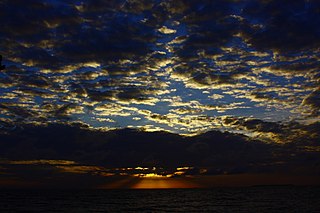
Cartagena, known since the colonial era as Cartagena de Indias, is a city and one of the major ports on the northern coast of Colombia in the Caribbean Coast Region, bordering the Caribbean sea. Cartagena's past role as a link in the route to West Indies provides it with important historical value for world exploration and preservation of heritage from the great commercial maritime routes. As a former Spanish colony, it was a key port for the export of Bolivian silver to Spain and for the import of enslaved Africans under the asiento system. It was defensible against pirate attacks in the Caribbean. The city's strategic location between the Magdalena and Sinú Rivers also gave it easy access to the interior of New Granada and made it a main port for trade between Spain and its overseas empire, establishing its importance by the early 1540s.

Pablo Emilio Escobar Gaviria was a Colombian drug lord, narcoterrorist, and politician, who was the founder and sole leader of the Medellín Cartel. Dubbed "the king of cocaine", Escobar was one of the wealthiest criminals in history, having amassed an estimated net worth of US$30 billion by the time of his death—equivalent to $70 billion as of 2022—while his drug cartel monopolized the cocaine trade into the United States in the 1980s and early 1990s.

Cozumel is an island and municipality in the Caribbean Sea off the eastern coast of Mexico's Yucatán Peninsula, opposite Playa del Carmen. It is separated from the mainland by the Cozumel Channel and is close to the Yucatán Channel. The municipality is part of the state of Quintana Roo, Mexico.

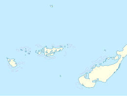
The Federal Dependencies of Venezuela encompass most of Venezuela's offshore islands in the Caribbean Sea and the Gulf of Venezuela, excluding those islands that form the State of Nueva Esparta and some Caribbean coastal islands that are integrated with nearby states. These islands, with a total area of 342 square kilometres, are sparsely populated – according to the preliminary results of the 2011 Census only 2,155 people live there permanently, with another hundred from Margarita Island who live there seasonally to engage in fishing. Local government is officially under the authority of Central government in Caracas, although de facto power is often held by the heads of the sparse and somewhat isolated communities that decorate the territories.

The Los Roques Archipelago is a federal dependency of Venezuela consisting of approximately 350 islands, cays, and islets in a total area of 40.61 square kilometers. The archipelago is located 128 kilometers (80 mi) directly north of the port of La Guaira, in the Caribbean Sea.
Jardines de la Reina is an archipelago in the southern part of Cuba, in the provinces of Camagüey and Ciego de Ávila.
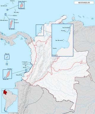
The insular region of Colombia includes the oceanic islands outside the continental territory. In the Caribbean this includes the San Andrés and Providencia islands near Central America and the many coastal islands along mainland Colombia. In the Pacific, it includes Gorgona Island and Malpelo Island. The ecosystems and wildlife found on these islands are the same as those found on their adjacent mainland areas. For example, the terrestrial habitat on Gorgona Island is tropical rainforest, similar to what is found in the Pacific lowlands of mainland Colombia.

The Tayrona National Natural Park is a protected area in the Colombian northern Caribbean region and within the jurisdiction of the city of Santa Marta, 34 kilometres (21 mi) from the city centre. The park presents a biodiversity endemic to the area of the Sierra Nevada de Santa Marta mountain range, featuring a variety of climates and geography that ranges from arid sea level to 900 meters above sea level. The park covers approximately 30 square kilometres (12 sq mi) of maritime area in the Caribbean sea and approximately 150 square kilometres (58 sq mi) of land.

San Andrés is a coral island in the Caribbean Sea. Politically part of Colombia, and historically tied to the United Kingdom, San Andrés and the nearby islands of Providencia and Santa Catalina form the department of San Andrés, Providencia and Santa Catalina. San Andrés, in the southern group of islands, is the largest of Colombia. The official languages of the department are Spanish, English, and San Andrés–Providencia Creole.
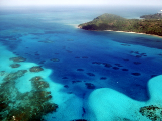
The Arrecifes de Cozumel National Park is off the coast of the island of Cozumel in the state of Quintana Roo, Mexico. The Cozumel reef system is part of the Mesoamerican Barrier Reef System, the second largest coral reef system in the world. Even though almost the entire island of Cozumel is surrounded by coral reefs, the park only encompasses the reefs on the south side of the island. It begins just south of the International Pier and continues down and around Punta Sur and up just a small portion of the east side of the island. The park contains both shallow and mesophotic coral reefs and extends to the 100 m depth isobar.
The Old Providence McBean Lagoon National Natural Park is a national park located on the northeast side of Providencia Island in the Archipelago of San Andrés, Providencia and Santa Catalina, Colombia.
The Rosario and San Bernardo Corals National Natural Park is a natural park located in the Sucre and Bolívar Departments on the coast of the Caribbean Region of Colombia, 45 km from the Bay of Cartagena. It was the most visited national park in Colombia in 2009, with 318,473 visitors.

Isla Bastimentos National Marine Park is a marine park located in the Bocas del Toro Archipelago, Panama. The park covers 13,226 hectares.

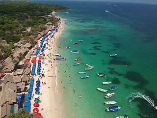
The Archipelago of San Bernardo is a set of nine coastal coral islands and one artificial island belonging to and governed by Colombia, located in the Gulf of Morrosquillo in the Caribbean Sea, with an approximate area of 213 km2. Administratively, the archipelago belongs to the Bolívar Department, with the exception of Boquerón Island, which belongs to the Sucre Department. It consists of Boquerón Island, Cabruna Island, Ceycén Island, Mangle Island, Múcura Island, Palma Island, Panda Island, Santa Cruz del Islote, Tintipán Island and Maravilla Island. All the 10 islands are close to the towns of Tolú and Coveñas.

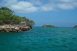
Múcura Island is a coral island located in the Archipelago of San Bernardo, Gulf of Morrosquillo, Caribbean Sea. It is governed by Colombia, and is a part of the District of Cartagena de Indias.

Fuerte Island is a small coral island in the Caribbean Sea off the northern coast of Colombia, Córdoba department, located south of the Gulf of Morrosquillo. It is located at a distance of 11 km from mainland Colombia. It is part of the chain of islands formed by the Rosario Islands, the Archipelago of San Bernardo and Tortuguilla.
The Isla Barú or Isla de Barú is a former peninsula south of Cartagena, Colombia. It was cut off from the mainland by the Canal del Dique, but is still connected by bridge. It projects out southwest from the southern end of Cartagena towards the Islas del Rosario. It is approximately 25 km long and in places is less than 1 km wide. Approximately 20,000 people live on the island.

Taganga is a traditional fishing village and corregimiento of Santa Marta, located on the Caribbean coast of Colombia at about 10 minutes or 3 kilometres (1.9 mi) north of Santa Marta. Both Santa Marta and Taganga were founded by Rodrigo de Bastidas on July 29, 1525, making them two of the oldest remaining colonial settlements in present-day Colombia.
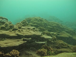
Coral Reef of Varadero is a coral reef located in the Bay of Cartagena, Colombia. Its paradoxical existence, harboring high coral cover and diversity despite the poor water quality and high sediment loads discharged into the Bay for the last 500 years by the Canal del Dique, has drawn special interest by the scientific community as well as local and international media. The persistence of Varadero reef is currently threatened by a project to modernize Cartagena’s port, which includes the dredging of a new shipping lane through the reef. The regular operation and maintenance of the channel is also likely to cause water quality in the Bay to deteriorate.
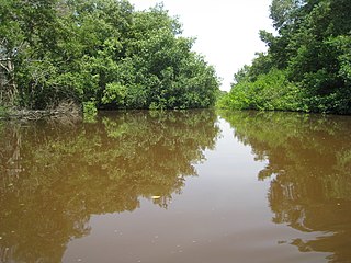
The Magdalena-Santa Marta mangroves ecoregion covers the mangrove forests along the coast of Colombia on the Caribbean Sea, from Gulf of Urabá in the west at the Colombia-Panama border to the Guajira Peninsula in the east. The region is relatively dry, with low precipitation and high evapotranspiration, so the mangroves depend for water and nutrients on the rivers flowing across the estuarine plain from the Sierra Nevada de Santa Marta mountains to the east. Efforts are currently underway to restore mangroves degraded by development and road building from the 1950s to 1980s.