Roseville, Illinois

Last updated

Village of Roseville
IL116wRoadSign-US67BusSign-Roseville (38531280205).jpg
Downtown Roseville
Warren County Illinois Incorporated and Unincorporated areas Roseville Highlighted.svg
Location of Roseville in Warren County, Illinois
USA Illinois location map.svg
Red pog.svg
Village of Roseville
Location within the state of Illinois
Coordinates: 40°43′51″N90°39′50″W / 40.73083°N 90.66389°W / 40.73083; -90.66389
Country United States
State Illinois
County Warren
Township Roseville
Government
  Village PresidentMorgan Wise [1]
Area
[2]
  Total0.74 sq mi (1.91 km2)
  Land0.74 sq mi (1.91 km2)
  Water0.00 sq mi (0.00 km2)
Elevation
[3]
742 ft (226 m)
Population
 (2020)
  Total892
  Density1,207.04/sq mi (465.99/km2)
Time zone UTC-6 (Central (CST))
  Summer (DST) UTC-5 (CDT)
Area code 309
FIPS code 17-65845
GNIS feature ID2399125 [3]
Website rosevilleil.com

Roseville is a village in Warren County, Illinois, United States. The population was 892 at the 2020 census. [4] It is part of the Galesburg Micropolitan Statistical Area.

Contents

Geography

According to the 2010 census, Roseville has a total area of 0.81 square miles (2.10 km2), all land. [5]

Demographics

Historical population
CensusPop.Note
1880 804
1890 788−2.0%
1900 1,01428.7%
1910 882−13.0%
1920 9527.9%
1930 9752.4%
1940 1,0618.8%
1950 1,0801.8%
1960 1,065−1.4%
1970 1,1114.3%
1980 1,25412.9%
1990 1,151−8.2%
2000 1,083−5.9%
2010 989−8.7%
2020 892−9.8%
2021 (est.)791 [6] −11.3%
U.S. Decennial Census [7]

As of the census [8] of 2000, there were 1,083 people, 438 households, and 296 families residing in the village. The population density was 1,333.3 inhabitants per square mile (514.8/km2). There were 478 housing units at an average density of 588.5 per square mile (227.2/km2). The racial makeup of the village was 99.45% White, 0.18% African American, 0.18% Native American, 0.09% Asian, and 0.09% from two or more races. Hispanic or Latino of any race were 0.46% of the population.

There were 438 households, out of which 28.1% had children under the age of 18 living with them, 54.8% were married couples living together, 10.0% had a female householder with no husband present, and 32.2% were non-families. 29.5% of all households were made up of individuals, and 17.8% had someone living alone who was 65 years of age or older. The average household size was 2.31 and the average family size was 2.83.

In the village, the population was spread out, with 21.6% under the age of 18, 7.0% from 18 to 24, 22.0% from 25 to 44, 22.4% from 45 to 64, and 27.0% who were 65 years of age or older. The median age was 44 years. For every 100 females, there were 80.5 males. For every 100 females age 18 and over, there were 74.7 males.

The median income for a household in the village was $32,031, and the median income for a family was $37,125. Males had a median income of $30,625 versus $18,594 for females. The per capita income for the village was $16,225. About 9.1% of families and 10.8% of the population were below the poverty line, including 13.0% of those under age 18 and 6.0% of those age 65 or over.

Notable people

Related Research Articles

<span class="mw-page-title-main">Mendon, Illinois</span> Village in Illinois, United States

Mendon is a village in Adams County, Illinois, United States. The population was 872 at the 2020 census. It is part of the Quincy, IL–MO Micropolitan Statistical Area.

<span class="mw-page-title-main">Avon, Illinois</span> Village in Illinois, United States

Avon is a village in Fulton County, Illinois, United States. The population was 799 at the 2010 census, down from 915 at the 2000 census.

<span class="mw-page-title-main">Kane, Illinois</span> Village in Illinois, United States

Kane is a village in Greene County, Illinois, United States. The population was 438 at the 2010 census.

<span class="mw-page-title-main">Godley, Illinois</span> Village in Illinois, United States

Godley is a village in Grundy and Will counties, Illinois, United States. The population was 601 at the 2010 census.

<span class="mw-page-title-main">Media, Illinois</span> Village in Illinois, United States

Media is a village in Henderson County, Illinois, United States. The population was 107 at the 2010 census, down from 130 at the 2000 census. It is part of the Burlington, IA–IL Micropolitan Statistical Area.

<span class="mw-page-title-main">St. Augustine, Illinois</span> Village in Illinois, United States

St. Augustine or Saint Augustine is a village in Knox County, Illinois, United States. The population was 120 at the 2010 census, down from 152 at the 2000 census. It is part of the Galesburg Micropolitan Statistical Area.

<span class="mw-page-title-main">Channel Lake, Illinois</span> Census-designated place in Illinois, United States

Channel Lake is an unincorporated community and census-designated place (CDP) in Antioch Township, Lake County, Illinois, United States. Per the 2020 census, the population was 1,581.

<span class="mw-page-title-main">Good Hope, Illinois</span> Village in Illinois, United States

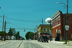
Good Hope is a village in McDonough County, Illinois, United States. Its population was 363 at the 2020 census.

<span class="mw-page-title-main">Witt, Illinois</span> City in Illinois, United States

Witt is a city in Montgomery County, Illinois, United States. The population was 785 at the 2020 census, down from 903 in 2010.

<span class="mw-page-title-main">Murrayville, Illinois</span> Village in Illinois, United States

Murrayville is a village in Morgan County, Illinois, United States. The population was 567 at the 2020 census. It is part of the Jacksonville Micropolitan Statistical Area.

<span class="mw-page-title-main">Lenzburg, Illinois</span> Village in Illinois, United States

Lenzburg is a village in St. Clair County, Illinois, USA. The population was 521 at the 2010 census.

<span class="mw-page-title-main">Kirkwood, Illinois</span> Village in Illinois, United States

Kirkwood is a village in Warren County, Illinois, United States. The population was 714 at the 2010 census. It is part of the Galesburg Micropolitan Statistical Area.

<span class="mw-page-title-main">Lacona, Iowa</span> City in Iowa, United States

Lacona is a city in Warren County, Iowa, United States. The population was 345 at the time of the 2020 census. It is part of the Des Moines metropolitan area.

<span class="mw-page-title-main">Roseville, Michigan</span> City in Michigan, United States

Roseville is a city in Macomb County in the U.S. state of Michigan. A northern suburb of Detroit, Roseville is located roughly 13 miles (20.9 km) northeast of downtown Detroit. As of the 2020 census, the city had a population of 47,710.

Roseville Township is a township in Grant County, Minnesota, United States. The population was 154 at the 2000 census.

Houston Township is a township in Houston County, Minnesota, United States. The population was 438 at the 2000 census.

Roseville Township is a township in Kandiyohi County, Minnesota, United States. The population was 570 at the 2000 census.

<span class="mw-page-title-main">Henning, Minnesota</span> City in Minnesota, United States

Henning is a city in Otter Tail County, Minnesota, United States. The population was 854 at the 2020 census.

<span class="mw-page-title-main">West Leipsic, Ohio</span> Village in Ohio, United States

West Leipsic is a village in Putnam County, Ohio, United States. The population was 226 at the 2020 census.

<span class="mw-page-title-main">Roseville, Ohio</span> Village in Ohio, United States

Roseville is a village in Muskingum and Perry counties in the U.S. state of Ohio, along Moxahala Creek. The population was 1,746 at the 2020 census. It is part of the Zanesville micropolitan area. Roseville is served by a branch of the Muskingum County Library System.

References

  1. "Warren County IL". Warren County IL. Retrieved October 2, 2023.
  2. "2020 U.S. Gazetteer Files". United States Census Bureau. Retrieved March 15, 2022.
  3. 1 2 U.S. Geological Survey Geographic Names Information System: Roseville, Illinois
  4. "Roseville village, Illinois - Census Bureau Profile". United States Census Bureau. Retrieved January 25, 2024.
  5. "G001 - Geographic Identifiers - 2010 Census Summary File 1". United States Census Bureau. Archived from the original on February 13, 2020. Retrieved December 25, 2015.
  6. "Total Population". U.S. Census Bureau.
  7. "Census of Population and Housing". Census.gov. Retrieved June 4, 2015.
  8. "U.S. Census website". United States Census Bureau . Retrieved January 31, 2008.