
Bloemfontein, also known as Bloem, is the capital and the largest city of the Free State province in South Africa. It is often, and has been traditionally, referred to as the country's "judicial capital", alongside the legislative capital Cape Town and administrative capital Pretoria, although the highest court in South Africa, the Constitutional Court, has been in Johannesburg since 1994.
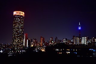
Johannesburg is the most populous city in South Africa with 4,803,262 people, and is classified as a megacity; it is one of the 100 largest urban areas in the world. It is the provincial capital and largest city of Gauteng, which is the wealthiest province in South Africa. Johannesburg is the seat of the Constitutional Court, the highest court in South Africa. Most of the major South African companies and banks have their head offices in Johannesburg. The city is located within the mineral-rich Witwatersrand hills, the epicentre of the international-scale mineral, gold and (specifically) diamond trade.

East London is a city on the southeastern coast of South Africa, in the Buffalo City Metropolitan Municipality, Eastern Cape Province. The city lies on the Indian Ocean coast, largely between the Buffalo River and the Nahoon River, and hosts the country's only river port. As of 2011, East London had a population of over 267,000 with over 755,000 in the surrounding metropolitan area.
Sharpeville is a township situated between two large industrial cities, Vanderbijlpark and Vereeniging, in southern Gauteng, South Africa. Sharpeville is one of the oldest of six townships in the Vaal Triangle. It was named after John Lillie Sharpe who came to South Africa from Glasgow, Scotland, as secretary of Stewarts & Lloyds. Sharpe was elected to the Vereeniging City Council in 1932 and held the position of mayor from 1934 to 1937.
Centurion is an area with 236,580 inhabitants in the Gauteng Province of South Africa, between Pretoria and Midrand. Formerly an independent municipality, with its own town council, it has been part of the City of Tshwane Metropolitan Municipality since 2000. Its heart is at the intersection of the N1 and N14 freeways. The R21 freeway also passes through the eastern part of Centurion.
Laudium is an Indian township southwest of central Pretoria, in the City of Tshwane Metropolitan Municipality. Claudius is a residential suburb that is effectively an extension of Laudium.

Cape Malays also known as Cape Muslims or Malays, are a Muslim community or ethnic group in South Africa. They are the descendants of enslaved and free Muslims from different parts of the world, specifically Indonesia and other Asian countries, who lived at the Cape during Dutch and British rule.

Vereeniging is a city located in the south of Gauteng province, South Africa, situated where the Klip River empties into the northern loop of the Vaal River. It is also one of the constituent parts of the Vaal Triangle region and was formerly situated in the Transvaal province. The name Vereeniging is the Dutch word meaning "association".

Fatima Meer was a South African writer, academic, screenwriter, and prominent anti-apartheid activist.

At least thirty-five languages are spoken in South Africa, twelve of which are official languages of South Africa: Ndebele, Pedi, Sotho, South African Sign Language, Swazi, Tsonga, Tswana, Venda, Afrikaans, Xhosa, Zulu and English, which is the primary language used in parliamentary and state discourse, though all official languages are equal in legal status. In addition, South African Sign Language was recognised as the twelfth official language of South Africa by the National Assembly on 3 May 2023. Unofficial languages are protected under the Constitution of South Africa, though few are mentioned by any name.

Alberton is a town situated on the southern part of the East Rand of the Gauteng Province in South Africa and is situated very close to the major urban centre of Johannesburg.
Inanda or eNanda is a township in KwaZulu-Natal, South Africa that is situated 21 km north-west of Durban. It forms part of eThekwini, the Greater Durban Metropolitan Municipality. Populated primarily by Zulu-speaking Black Africans, Inanda is the home of John Langalibalele Dube, first President of the African National Congress (ANC), a former residence and base of operations of Mahatma Gandhi, and the birthplace of the syncretic Nazareth Baptist Church
Rustenburg is a city at the foot of the Magaliesberg mountain range. Rustenburg is the most populous city in North West province, South Africa. In 2017, the city's Gross Domestic Product (GDP) reached ZAR 63.8 billion, accounting for 21.1% of the GDP of the North West Province, and 1.28% of the GDP of South Africa. Rustenburg was one of the official host cities of the 2010 FIFA World Cup, being in close proximity to Phokeng, the capital of the Royal Bafokeng Nation, where the Royal Bafokeng Stadium is located. The England national football team also used this as their base camp for the tournament.
Tsakane is a township located in Ekurhuleni, Gauteng, South Africa. It was established during the early 1960s due to Apartheid's segregationist policies and was formally founded as a designated area. Tsakane is a Tsonga word which means joy or Tsakane is associated with the townships,Kwa thema and Duduza,being called Kwatsaduza in Ekurhuleni.
Chatsworth is a large township in KwaZulu-Natal, South Africa established in the 1950s to segregate the Indian population and create a buffer between the white suburbs of Durban to the north and the black townships of Durban to the south. Located in the Southern Durban basin and roughly bordered by the Umhlatuzana River in the North and Umlaas River in the South, the suburb is made up mainly of Indian/Asian and Black African people.

Gugulethu is a township in the Western Cape, South Africa and is 15 km from Cape Town. Its name is a contraction of igugu lethu, which is Xhosa for our pride. The township was established along with Nyanga in the 1960s.

Mitchells Plain is a large township located within the City of Cape Town, Western Cape, South Africa and situated about 28 km (17 mi) from the Cape Town city centre. It is one of South Africa's largest residential areas and contains multiple smaller suburbs. It is located on the Cape Flats on the False Bay coast between Muizenberg and Khayelitsha. Conceived of as a "model suburb" by the apartheid government, it was built during the 1970s to provide housing for Coloured victims of forced removal due to the implementation of the Group Areas Act.

Nyanga is a township in the Western Cape, South Africa. Its name in Xhosa means "moon" and it is one of the oldest black townships in Cape Town. It was established as a result of the migrant labour system. In 1948 black migrants were forced to settle in Nyanga as Langa had become too small. Nyanga was one of the poorest places in Cape Town and is still one of the most dangerous parts of Cape Town. In 2001 its unemployment rate was estimated at being approximately 56% and HIV/AIDS is a huge community issue.

Manenberg is a township of Cape Town, South Africa, that was created by the apartheid government for low-income Coloured families in the Cape Flats in 1966 as a result of the forced removal campaign by the National Party. It has an estimated population of 52,000 residents. The area consists of rows of semi-detached houses and project-like flats, known as "korre". The township is located about 20 km away from the city centre of Cape Town. It is separated from neighbouring Nyanga and Gugulethu townships by a railway line to the east and from Hanover Park by the Sand Industria industrial park to the west and Heideveld to the north. The northern part of Manenberg has wealthy people that are mostly Muslims. The rest of Manenberg has poor people that are mostly associated with Christianity.
Azaadville is a town in South Africa located in Mogale City in the West Rand region of Gauteng province of South Africa.

