
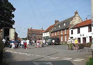
Blakeney is a coastal village and civil parish in the English county of Norfolk. Blakeney lies within the Norfolk Coast AONB and the North Norfolk Heritage Coast. The North Norfolk Coastal Path travels along its quayside. The village is 21.1 mi (34 km) north west of Norwich, 4.6 mi (7.4 km) NNW of the larger settlement of Holt, 11.5 mi (18.5 km) west of Cromer and 112 mi (180 km) NNE of London.

Herringfleet is a place and former civil parish in the north of the English county of Suffolk. It is located 5.5 miles (8.9 km) north-west of Lowestoft in the East Suffolk district. The parish was combined with Somerleyton and Ashby to create the parish of Somerleyton, Ashby and Herringfleet in 1987.

Wymondham is a market town and civil parish in the South Norfolk district of Norfolk, England, 12 miles (19 km) south-west of Norwich off the A11 road to London. The River Tiffey runs through. The parish, one of Norfolk's largest, includes rural areas to the north and south, with hamlets of Suton, Silfield, Spooner Row and Wattlefield. It had a population of 14,405 in 2011, of whom 13,587 lived in the town itself.

North Walsham is a market town and civil parish in Norfolk, England, within the North Norfolk district.
Worstead is a village and civil parish in the English county of Norfolk. It lies 3 miles (5 km) south of North Walsham, 5 miles (8 km) north of Wroxham, and 13 miles (21 km) north of Norwich. The village is served by Worstead railway station on the Bittern Line. For the purposes of local government, the parish falls within the district of North Norfolk.

Anmer is a small village and civil parish in the English county of Norfolk. It is around 12 miles (19 km) north-east of the town of King's Lynn and 35 miles (56 km) north-west of the city of Norwich. The parish is in the district of King's Lynn and West Norfolk and at the 2001 census had a population of 63 in 29 households.

Barton Bendish is a civil parish and small ancient village in the English county of Norfolk located 10 miles South of King's Lynn and 90 miles North East of London. It has two medieval parish churches, and once had three. The parish includes the old hamlet of Eastmoor, and covers 3936 acres . The village has been settled since Neolithic times and was expanded during the Saxon period. Today the village has a population of 210 as recorded at the 2010 census and contains eight listed buildings, with the two medieval parishes churches being Grade I.

Beachamwell is a village and civil parish in the Breckland district of Norfolk, England about 5 miles (8.0 km) south west of Swaffham and 10 miles (16 km) east of Downham Market. It has four ancient churches, two of them in ruins. The former parish of Shingham has been annexed.

Beighton is a village and civil parish in the Broadland district of Norfolk, England, about two miles (3 km) South-West of Acle about 12.8 miles (20.6 km) to Norwich. It covers an area of 7.63 km2 and has a population of 436 in 185 households according to the 2011 census. Today, Beighton incorporates the old parish of Moulton St Mary, and both parishes are mentioned in the Domesday Book of 1086. The All Saints church is situated within Beighton, along Church Hill. The church was described in 1870 as:
The church is decorated English, and was recently restored.

Wolterton Hall, is a large country house in the ecclesiastical parish of Wickmere with Wolterton and the civil parish of Wickmere in the English county of Norfolk, England, United Kingdom. The present hall was commissioned by the 1st Lord Walpole of Wolterton and completed in 1742, it was designed by the architect Thomas Ripley who was a protégé of Lord Walpole and his brother Sir Robert Walpole.

Ashwicken is a small village and former civil parish, now in the parish of Leziate, in the King's Lynn and West Norfolk district, in the county of Norfolk, England. The village sits on the B1145 King's Lynn to Mundesley road around 5 miles (8.0 km) east of King's Lynn. In 1931 the parish had a population of 117. On 1 April 1935 the parish was abolished and merged with Leziate.

Oulton is a village and civil parish in Norfolk, England. Nearby towns are Reepham and Aylsham. The parish covers an area of 10.58 km2 (4.08 sq mi) and had a population of 196 in 74 households at the 2001 census, reducing slightly to a population of 193 in 81 households at the 2011 census. The village is dispersed with one area of settlement in the vicinity of the church of Saints Peter and Paul, and another area along Oulton Street to the east.

Harrington is a village and civil parish in Northamptonshire, England, administered by North Northamptonshire council. At the time of the 2001 census, the parish's population was 154 people, including Thorpe Underwood but reducing to 146 at the 2011 Census. The Church of England parish church of St Peter and St Paul is located north-east of the village itself.

Brettenham is a village and civil parish in the English county of Norfolk. It covers an area of 26.37 km2 (10.18 sq mi) and had a population of 475 in 159 households at the 2001 census, including Rushford and increasing to 555 at the 2011 Census. For the purposes of local government, it falls within the district of Breckland.

Larling is a village and former civil parish, now in the parish of Roudham and Larling, in the Breckland district, in the county of Norfolk, England. The village is 8.5 miles east north east of Thetford, 21.4 miles west south west of Norwich and 94 miles north east of London. In 1931 the parish had a population of 159.

Leziate is a village and civil parish in the English county of Norfolk. The village is 44 miles (71 km) west of Norwich, 5.7 miles (9.2 km) east of King's Lynn and 106 miles (171 km) north-north-east of London. The Village is located a small distance south of the B1145 a route which runs between King's Lynn and Mundesley. The nearest railway station is at King's Lynn for the Fen Line which runs between King's Lynn and Cambridge. The nearest airport is Norwich International Airport. The parish of Leziate in the 2001 census, has a population of 581, including Ashwicken and increasing to 592 at the 2011 census.

Mundham, historically Mundaham or Mundhala, is a small village and civil parish in the county of Norfolk, England. Archaeological and toponymic evidence of Mundham's existence predates its appearance in the Domesday survey of 1086, dating back to the early Anglo Saxon period. However, there has been activity in the area since the early Neolithic period, as well as an small Roman settlement which was located within the village. In 2001, the population was 168 in 63 households, and grew to 177 at the 2011 census. The parish covers an area of 6.31 km2 (2.44 sq mi), and is approximately 9 miles (14.5 km) south of Norwich and 14 miles (23 km) west of Great Yarmouth.

Roudham and Larling is a civil parish in the English county of Norfolk. It includes the villages of Roudham and Larling. It covers an area of 15.20 km2 (5.87 sq mi) and had a population of 278 in 119 households at the 2001 census, increasing to a population of 301 in 119 households at the 2011 Census. For the purposes of local government, it falls within the district of Breckland. River Thet flows next to Roudham and Larling.
Bixley medieval settlement is a deserted medieval village in Norfolk, England, about 2 miles (3.2 km) south-east of Norwich. It is a Scheduled Monument.
