
Hong Kong has a highly developed and sophisticated transport network, encompassing both public and private transport. Based on Hong Kong Government's Travel Characteristics Survey, over 90% of the daily journeys are on public transport, the highest rate in the world. However, in 2014 the Transport Advisory Committee, which advises the Government on transportation issues, issued a report on the much worsened congestion problem in Hong Kong and pointed at the excessive growth of private cars during the past 10–15 years.

Sha Tin District is one of the 18 districts of Hong Kong. As one of the 9 districts located in the New Territories, it covers the areas of Sha Tin, Tai Wai, Ma On Shan, Fo Tan, Siu Lek Yuen, Kwun Yam Shan and Ma Liu Shui. The district is the most populous district in Hong Kong, with a population of 659,794 as per 2016 by-census, having a larger population than many states or dependencies including Iceland, Malta, Montenegro and Brunei.

Tuen Mun Road is a major expressway in Hong Kong which connects Tuen Mun with Tsuen Wan, within the New Territories. It is part of Hong Kong's Route 9, which circumnavigates the New Territories. Opened in 1978, it was once the major trunk route linking the northwest New Territories to urban Kowloon and is known for its frequent traffic jams and road accidents owing to its early design and heavy usage. As a result, speed limits have been enforced to 70–80 km/h (45–50 mph) due to geometric constraints.

Route 9, Hong Kong is one of the strategic trunk roads, mostly in the form of a motorway, circumnavigating the New Territories. The route is also known as the New Territories Circular Road (新界環迴公路). Starting from the Shing Mun Tunnels, Route 9 links Sha Tin, Tai Po, Fanling, Sheung Shui, Yuen Long, Tuen Mun and Tsuen Wan. The section between Exit 10 in Kwu Tung and Exit 16 in Lam Tei is part of Asian Highway 1, although the Asian Highway Network is not signed in Hong Kong.

Tuen Mun or Castle Peak is an area near the mouth of Tuen Mun River and Castle Peak Bay in the New Territories, Hong Kong. It was one of the earliest settlements in what is now Hong Kong and can be dated to the Neolithic period. In the more recent past, it was home to many Tanka fishermen who gathered at Castle Peak Bay. Tuen Mun is now a modern, mainly residential area in the north-west New Territories. As of 2011, 487,546 live in Tuen Mun and over 95% of them are Chinese.

Tai Lam Tunnel, running along Tsing Long Highway, is part of Route 3 Country Park Section (R3CPS) and is a transport link between the western New Territories in Ting Kau and Yuen Long.

Tuen Mun Ferry Pier (屯門碼頭), or Tuen Mun Ferry Terminal, is a public pier located in the southern area of Tuen Mun, Hong Kong.

Lam Tei is an area in the Tuen Mun District of the New Territories, Hong Kong. The region lies at the north end of Tuen Mun city. It is highly rural, with Miu Fat Buddhist Monastery being a landmark of the region.

North Lantau Highway is an expressway forming part of Hong Kong's Route 8, linking Hong Kong International Airport and Lantau Island with the rest of the territory. The road has three lanes in each direction for its entire length with full-width hard shoulders for emergencies and breakdowns. The speed limit is 110 kilometres per hour (68 mph) for most of its length, the highest of any road in Hong Kong.

The Hong Kong Strategic Route and Exit Number System is a system adopted by the Transport Department of the Hong Kong Government to organise the major roads in the territory into routes 1 to 10 for the convenience of drivers. When the system was implemented in 2004, the government promoted it with a major public campaign, including the slogan "Remember the Numbers; Make Driving Easier".

Yuen Long Highway is a Hong Kong expressway connecting Au Tau in Yuen Long and Lam Tei in Tuen Mun of New Territories.

The Hong Kong–Shenzhen Western Corridor, also known for the main component Shenzhen Bay Bridge, is a cross-border highway between Shenzhen, Guangdong Province and Hong Kong. The highway bridge is a 5.5-kilometre (3.4 mi) dual three-lane controlled-access highway. It connects Ngau Hom Shek, Hong Kong, to Dongjiaotou, which is administratively located in Nanshan District of Shenzhen. The corridor also had other components, a border checkpoint Shenzhen Bay Port, built on reclaimed land, as well as roads that connect the corridor to the existing road network of Shenzhen.

Skypier is a cross-border ferry pier integrated within Hong Kong International Airport, Chek Lap Kok, New Territories, Hong Kong. It is operated by Hong Kong International Airport Ferry Terminal Services Limited, a joint-venture company between Chu Kong Passenger Transport Co., Ltd and Shun Tak-China Travel Ship Management Limited. At this pier, passengers aboard can transit from Hong Kong International Airport to piers in the Pearl River Delta of Guangdong Province or vice versa, without immigration and customs clearance through Hong Kong.

Kong Sham Western Highway, formerly known as the Deep Bay Link is a highway in Hong Kong. It is 5.4 kilometres (3.4 mi) long and has three lanes in each direction. Its northern end is at Ngau Hom Shek, near Deep Bay, and its southern end is at Lam Tei, in Tuen Mun District. Together with the Hong Kong–Shenzhen Western Corridor, it forms the Route 10 of the Hong Kong Strategic Route and Exit Number System and provides road access from Hong Kong to the mainland. The link itself consists of 108,000 m2 of deck space over 3,014 segments.
Hong Kong–Shenzhen Western Express Railway is a proposed cross-border railway offering three future distinct services, Hong Kong International Airport – Shenzhen Bao'an International Airport direct connection, Hung Shui Kiu–Qianhai cross border services and domestic service between Tuen Mun and Siu Ho Wan.
Tsing Lung Bridge (青龍大橋) is a proposed suspension bridge in Hong Kong, from North Lantau to Tsing Lung Tau, in the western New Territories, between Tsuen Wan and Tuen Mun, forming part of the Route 10 North Lantau to Yuen Long Highway. The bridge and highway have not been constructed. At the time of its announcement in 2002, it would have been the world's 4th-longest suspension bridge, with a main span of 1,418 metres (4,652 ft) - 41 metres longer than the Tsing Ma Bridge. Detailed planning was then complete and construction was due to commence in 2003 and be open to traffic in 2008.

The Tuen Mun–Chek Lap Kok Link is a road project in the New Territories, Hong Kong. It comprises two elements: the "Northern Connection" and the "Southern Connection". The Northern Connection comprises an undersea tunnel crossing the Urmston Road, linking Tuen Mun to the "Boundary Crossing Facilities" (BCF), an artificial peninsula connected to Hong Kong International Airport. The Southern Connection, officially named Shun Long Road, comprises viaducts linking the BCF to North Lantau Highway on Lantau Island.
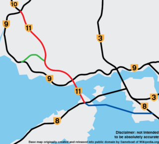
Route 11 is a planned trunk route in Hong Kong numbered under the Hong Kong Strategic Route and Exit Number System. It is planned to be opened to vehicular traffic in its entirety by 2033, and no later than 2036. Route 11 is the culmination of various cancelled or modified plans such as the Tuen Mun Bypass and the original alignment of Route 10.


